Welcome to Visit Staden, Derbyshire Places
The Walkfo guide to things to do & explore in Staden, Derbyshire
![]() Visit Staden, Derbyshire places using Walkfo for free guided tours of the best Staden, Derbyshire places to visit. A unique way to experience Staden, Derbyshire’s places, Walkfo allows you to explore Staden, Derbyshire as you would a museum or art gallery with audio guides.
Visit Staden, Derbyshire places using Walkfo for free guided tours of the best Staden, Derbyshire places to visit. A unique way to experience Staden, Derbyshire’s places, Walkfo allows you to explore Staden, Derbyshire as you would a museum or art gallery with audio guides.
Visiting Staden, Derbyshire Walkfo Preview
Staden is a small hamlet (of just a few buildings) on the southern outskirts of Buxton, Derbyshire, lying between Harpur Hill and Cowdale. It was occupied in Neolithic, Roman and medieval times. Neolithic artefacts were discovered during excavations in 1926 by Mr R. Woolescroft, including a polished stone axe head and fragments of knapped flint. When you visit Staden, Derbyshire, Walkfo brings Staden, Derbyshire places to life as you travel by foot, bike, bus or car with a mobile phone & headphones.
Staden, Derbyshire Places Overview: History, Culture & Facts about Staden, Derbyshire
Visit Staden, Derbyshire – Walkfo’s stats for the places to visit
With 52 audio plaques & Staden, Derbyshire places for you to explore in the Staden, Derbyshire area, Walkfo is the world’s largest heritage & history digital plaque provider. The AI continually learns & refines facts about the best Staden, Derbyshire places to visit from travel & tourism authorities (like Wikipedia), converting history into an interactive audio experience.
Why visit Staden, Derbyshire with Walkfo Travel Guide App?
![]() You can visit Staden, Derbyshire places with Walkfo Staden, Derbyshire to hear history at Staden, Derbyshire’s places whilst walking around using the free digital tour app. Walkfo Staden, Derbyshire has 52 places to visit in our interactive Staden, Derbyshire map, with amazing history, culture & travel facts you can explore the same way you would at a museum or art gallery with information audio headset. With Walkfo, you can travel by foot, bike or bus throughout Staden, Derbyshire, being in the moment, without digital distraction or limits to a specific walking route. Our historic audio walks, National Trust interactive audio experiences, digital tour guides for English Heritage locations are available at Staden, Derbyshire places, with a AI tour guide to help you get the best from a visit to Staden, Derbyshire & the surrounding areas.
You can visit Staden, Derbyshire places with Walkfo Staden, Derbyshire to hear history at Staden, Derbyshire’s places whilst walking around using the free digital tour app. Walkfo Staden, Derbyshire has 52 places to visit in our interactive Staden, Derbyshire map, with amazing history, culture & travel facts you can explore the same way you would at a museum or art gallery with information audio headset. With Walkfo, you can travel by foot, bike or bus throughout Staden, Derbyshire, being in the moment, without digital distraction or limits to a specific walking route. Our historic audio walks, National Trust interactive audio experiences, digital tour guides for English Heritage locations are available at Staden, Derbyshire places, with a AI tour guide to help you get the best from a visit to Staden, Derbyshire & the surrounding areas.
“Curated content for millions of locations across the UK, with 52 audio facts unique to Staden, Derbyshire places in an interactive Staden, Derbyshire map you can explore.”
Walkfo: Visit Staden, Derbyshire Places Map
52 tourist, history, culture & geography spots
Staden, Derbyshire historic spots | Staden, Derbyshire tourist destinations | Staden, Derbyshire plaques | Staden, Derbyshire geographic features |
| Walkfo Staden, Derbyshire tourism map key: places to see & visit like National Trust sites, Blue Plaques, English Heritage locations & top tourist destinations in Staden, Derbyshire | |||
Best Staden, Derbyshire places to visit
Staden, Derbyshire has places to explore by foot, bike or bus. Below are a selection of the varied Staden, Derbyshire’s destinations you can visit with additional content available at the Walkfo Staden, Derbyshire’s information audio spots:
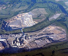
 | Great Rocks Dale Great Rocks Dale is a dry valley in the Derbyshire Peak District known for its extensive quarrying. It is also known for extensive quarry quarrying in the Peak District. |
 | Buxton Town Hall Buxton Town Hall was opened in 1889 on the Market Place in Buxton, Derbyshire. It lies in the town’s central Conservation Area overlooking The Slopes. It is a Grade-II listed building. |
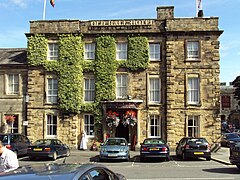
 | Old Hall Hotel The Old Hall Hotel is one of the oldest buildings in Buxton, Derbyshire, England. The current building dates from the Restoration period, built around and incorporating an earlier fortified tower. It is believed to be the earliest known British building of cross-axial form. |
 | St John The Baptist Church, Buxton St John The Baptist Church is a Grade II* listed parish church in Buxton, Derbyshire. The church was built in the 1930s and is located in the area of Buxton. It is now owned by the Church of England. |
 | Cavendish Hospital Cavendish Hospital is a geriatric healthcare facility in Buxton, Derbyshire. The hospital is managed by Derbyhire Community Health Services NHS Foundation Trust. |
 | Poole’s Cavern Pooles Cavern is a two-million-year-old natural limestone cave on the edge of Buxton in the Peak District, in Derbyshire, England. The cave forms part of the Wye system, and has been designated a Site of Special Scientific Interest. |
 | Buxton Pavilion Gardens Buxton Pavilion Gardens is a Victorian landscaped public park in the spa town of Buxton in Derbyshire. The River Wye flows through the gardens, which are a Grade II* listed public park of Special Historic Interest. |
 | Harpur Hill Quarry Limestone was extracted there from 1835 to 1952 for lime burning at lime kilns to produce quicklime. The quarry was used by the Royal Air Force as a chemical weapons storage depot during the Second World War. The RAF depot closed in 1960 and the site is now vacant. A small part of the abandoned quarry has flooded to become a quarry lake. |
 | Health and Safety Laboratory The Health and Safety Laboratory (HSE Laboratory or HSL Buxton) is a large 550-acre research site in rural High Peak, Derbyshire. It researches new methods in industrial safety. |
Visit Staden, Derbyshire plaques
![]() 13
13
plaques
here Staden, Derbyshire has 13 physical plaques in tourist plaque schemes for you to explore via Walkfo Staden, Derbyshire plaques audio map when visiting. Plaques like National Heritage’s “Blue Plaques” provide visual geo-markers to highlight points-of-interest at the places where they happened – and Walkfo’s AI has researched additional, deeper content when you visit Staden, Derbyshire using the app. Experience the history of a location when Walkfo local tourist guide app triggers audio close to each Staden, Derbyshire plaque. Explore Plaques & History has a complete list of Hartlepool’s plaques & Hartlepool history plaque map.