Welcome to Visit St Hilary, Vale of Glamorgan Places
The Walkfo guide to things to do & explore in St Hilary, Vale of Glamorgan
![]() Visit St Hilary, Vale of Glamorgan places using Walkfo for free guided tours of the best St Hilary, Vale of Glamorgan places to visit. A unique way to experience St Hilary, Vale of Glamorgan’s places, Walkfo allows you to explore St Hilary, Vale of Glamorgan as you would a museum or art gallery with audio guides.
Visit St Hilary, Vale of Glamorgan places using Walkfo for free guided tours of the best St Hilary, Vale of Glamorgan places to visit. A unique way to experience St Hilary, Vale of Glamorgan’s places, Walkfo allows you to explore St Hilary, Vale of Glamorgan as you would a museum or art gallery with audio guides.
Visiting St Hilary, Vale of Glamorgan Walkfo Preview
St Hilary (Welsh: Saint Hilari ) is a village in the Vale of Glamorgan, Wales. It is located just south of the A48, about a mile southeast of Cowbridge. The village has a population of about 260, in approximately 80 houses. When you visit St Hilary, Vale of Glamorgan, Walkfo brings St Hilary, Vale of Glamorgan places to life as you travel by foot, bike, bus or car with a mobile phone & headphones.
St Hilary, Vale of Glamorgan Places Overview: History, Culture & Facts about St Hilary, Vale of Glamorgan
Visit St Hilary, Vale of Glamorgan – Walkfo’s stats for the places to visit
With 32 audio plaques & St Hilary, Vale of Glamorgan places for you to explore in the St Hilary, Vale of Glamorgan area, Walkfo is the world’s largest heritage & history digital plaque provider. The AI continually learns & refines facts about the best St Hilary, Vale of Glamorgan places to visit from travel & tourism authorities (like Wikipedia), converting history into an interactive audio experience.
St Hilary, Vale of Glamorgan landmarks
The Bush Inn is situated in the Vale of Glamorgan and dates back to medieval times. The village has a parish church, rectory, and a pub, the thatched roofed Grade II listed Bush Inn. To the southeast of the village is the Coed Hills Rural Landscape, an alternative artspace.
Country houses

Old Beaupre Castle was one of the palaces of the royal house of Sitsyllt, progenitors of the Cecils, Marquesses of Salisbury and Exeter. Grade II listed New Beaupre is situated about 0.5 miles (0.80 km) to the north of the castle. St Hilary Cottage was the residence of the late Llewelyn Traherne.
Church

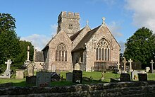
The 14th century, red-tiled Grade II* listed Church of St Hilary is a substantial structure in the later English style, consisting of a nave, south aisle, and chancel. The nave is 45 feet (14 m) long and 33 feet (10 m) broad including the aisle.
Mast

St Hilary mast was built in 1957 for transmitting the now-defunct 405-line/Channel 7 TV system to South Wales and the West of England.
St Hilary, Vale of Glamorgan geography / climate

The village lies just south of the A48, a few miles west of Cardiff and about a mile southeast of Cowbridge. In 1845, it had a population of 164 people and had an area of 1,200 acres. The St Hilary Conservation Area was designated a special architectural and historic interest site in October 1971.
Why visit St Hilary, Vale of Glamorgan with Walkfo Travel Guide App?
![]() You can visit St Hilary, Vale of Glamorgan places with Walkfo St Hilary, Vale of Glamorgan to hear history at St Hilary, Vale of Glamorgan’s places whilst walking around using the free digital tour app. Walkfo St Hilary, Vale of Glamorgan has 32 places to visit in our interactive St Hilary, Vale of Glamorgan map, with amazing history, culture & travel facts you can explore the same way you would at a museum or art gallery with information audio headset. With Walkfo, you can travel by foot, bike or bus throughout St Hilary, Vale of Glamorgan, being in the moment, without digital distraction or limits to a specific walking route. Our historic audio walks, National Trust interactive audio experiences, digital tour guides for English Heritage locations are available at St Hilary, Vale of Glamorgan places, with a AI tour guide to help you get the best from a visit to St Hilary, Vale of Glamorgan & the surrounding areas.
You can visit St Hilary, Vale of Glamorgan places with Walkfo St Hilary, Vale of Glamorgan to hear history at St Hilary, Vale of Glamorgan’s places whilst walking around using the free digital tour app. Walkfo St Hilary, Vale of Glamorgan has 32 places to visit in our interactive St Hilary, Vale of Glamorgan map, with amazing history, culture & travel facts you can explore the same way you would at a museum or art gallery with information audio headset. With Walkfo, you can travel by foot, bike or bus throughout St Hilary, Vale of Glamorgan, being in the moment, without digital distraction or limits to a specific walking route. Our historic audio walks, National Trust interactive audio experiences, digital tour guides for English Heritage locations are available at St Hilary, Vale of Glamorgan places, with a AI tour guide to help you get the best from a visit to St Hilary, Vale of Glamorgan & the surrounding areas.
“Curated content for millions of locations across the UK, with 32 audio facts unique to St Hilary, Vale of Glamorgan places in an interactive St Hilary, Vale of Glamorgan map you can explore.”
Walkfo: Visit St Hilary, Vale of Glamorgan Places Map
32 tourist, history, culture & geography spots
St Hilary, Vale of Glamorgan historic spots | St Hilary, Vale of Glamorgan tourist destinations | St Hilary, Vale of Glamorgan plaques | St Hilary, Vale of Glamorgan geographic features |
| Walkfo St Hilary, Vale of Glamorgan tourism map key: places to see & visit like National Trust sites, Blue Plaques, English Heritage locations & top tourist destinations in St Hilary, Vale of Glamorgan | |||
Best St Hilary, Vale of Glamorgan places to visit
St Hilary, Vale of Glamorgan has places to explore by foot, bike or bus. Below are a selection of the varied St Hilary, Vale of Glamorgan’s destinations you can visit with additional content available at the Walkfo St Hilary, Vale of Glamorgan’s information audio spots:

St Donat’s Church, Welsh St Donats
Records of 1180 describe the church as a chapel confirmed to the Abbey of Tewkesbury. By 1563 it was known to have served as a parish church for the community. By 1764 it received a stipend from Queen Anne’s Bounty and was described as a curacy.

Church of the Holy Cross, Cowbridge
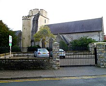
The Church of the Holy Cross is a medieval church in Cowbridge in the Vale of Glamorgan, south Wales. Believed to have been built in the 13th century, the church has an unusual tower design. It was listed as a Grade I building on 12 May 1963.

Cowbridge town wall
Cowbridge town wall is a Grade II*-listed medieval wall in the small market town of Cowbridge in the Vale of Glamorgan, south Wales. The walls were built by about 1300 and are believed to have been used to collect tolls from the town’s market, held twice-weekly.

Church of St John the Baptist, Llanblethian
The Church of St John the Baptist is a medieval church in Llanblethian in the Vale of Glamorgan, south Wales. Believed to have been built in the 12th century, the church boasts an unusual tower. It underwent extensive restoration in the late 19th century.

St Hilary’s Church, St Hilary (Vale of Glamorgan)
The Parish Church of St Hilary (Welsh: Eglwys Sant Ilar) is a Grade II* listed Anglican church in the Vale of Glamorgan, south Wales. It is one of 11 churches in the Parish of Cowbridge.

Old Beaupre Castle
Old Beaupre Castle (Welsh: Hen Gastell y Bewpyr) is a ruined medieval fortified manor house in Llanfair, outside Cowbridge in Wales. It is a Grade I listed building and is presently under the care of Cadw.
Vale of Glamorgan
The Vale of Glamorgan is a principal area with county borough status . It borders Cardiff, Cardiff, Rhondda Cynon Taf, Bridgend County Borough to the west, Cardiff to the east and the Bristol Channel to the south . It is the southernmost unitary authority in Wales . The largest town is Barry, with Penarth, Llantwit Major and Cowbridge .

Llanmihangel Place
Llanmihangel Place is a Grade I listed manor house in the Vale of Glamorgan, South Wales. The house dates back to the 12th century, when it was constructed as a single-storey dwelling.

Llandough Castle
Llandough Castle is a 14th-century tower house located in the Vale of Glamorgan, South Wales. It was assigned Grade II* listed building status in 1981. It is currently a private residence.
Visit St Hilary, Vale of Glamorgan plaques
![]() 1
1
plaques
here St Hilary, Vale of Glamorgan has 1 physical plaques in tourist plaque schemes for you to explore via Walkfo St Hilary, Vale of Glamorgan plaques audio map when visiting. Plaques like National Heritage’s “Blue Plaques” provide visual geo-markers to highlight points-of-interest at the places where they happened – and Walkfo’s AI has researched additional, deeper content when you visit St Hilary, Vale of Glamorgan using the app. Experience the history of a location when Walkfo local tourist guide app triggers audio close to each St Hilary, Vale of Glamorgan plaque. Explore Plaques & History has a complete list of Hartlepool’s plaques & Hartlepool history plaque map.
