Welcome to Visit St Buryan Places
The Walkfo guide to things to do & explore in St Buryan
 Visit St Buryan places using Walkfo for free guided tours of the best St Buryan places to visit. A unique way to experience St Buryan’s places, Walkfo allows you to explore St Buryan as you would a museum or art gallery with audio guides.
Visiting St Buryan Walkfo Preview
St Buryan (Cornish: Pluwveryan) is a village and former civil parish, now in the parish of St Baryan, Lamorna and Paul in Cornwall. Named after the Irish Saint Buriana, the parish is situated 5 miles (8.0 km) west of Penzance along the B3283 towards Land’s End. When you visit St Buryan, Walkfo brings St Buryan places to life as you travel by foot, bike, bus or car with a mobile phone & headphones.
St Buryan Places Overview: History, Culture & Facts about St Buryan
Visit St Buryan – Walkfo’s stats for the places to visit
With 39 audio plaques & St Buryan places for you to explore in the St Buryan area, Walkfo is the world’s largest heritage & history digital plaque provider. The AI continually learns & refines facts about the best St Buryan places to visit from travel & tourism authorities (like Wikipedia), converting history into an interactive audio experience.
St Buryan history
St Buryan and the surrounding area is rich in history and has been a centre of human activity for several thousand years. The surrounding area has a rich history of its human activity.
Early Neolithic Period

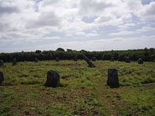
The area surrounding St Buryan was in use by humans in Neolithic times, as is evident from surviving monuments. Boscawen-Un, a neolithic stone circle containing 19 stones around a leaning central pillar, is thought to be complete. A more accessible stone circle, The Merry Maidens, lies 2 miles (3.2 km) to the south of the village in a field along the B3315 toward Land’s End.
Bronze and Iron Ages
Only a few hundred yards from the site of the Merry Maidens lies a Bronze Age burial chamber, Cruk Tregyffian, that was discovered (and unfortunately damaged) during widening of the adjacent B3315 road. The Boleigh Fogou is considered to be one of the best remaining monuments of its kind in Cornwall. Built in the Iron Age, the purpose of fogous (derived from Cornish word for cave) is not known.
Middle Ages
A revolt against the Anglo-Saxon English in 931 AD by the Cornish Celts (supported by the Danes) led to a battle southeast of the village at Boleigh where a farm and hamlet now stands. The establishment of a church and monastery in the village by Athelstan contributed to the rising importance of the parish. In 1328 St Buryan was excommunicated from the church over a row about control of religious matters.
Tudor and Stuart period

William Noy was an MP and member of the court of King Charles I. He was created Attorney-General to the king in October 1631 and specialised in reviving long forgotten taxes to raise money to fund the King’s lifestyle. His advice controversially led to the imposition of ship money which is thought by many to have helped trigger the English Civil War. Cornwall was a haven for smugglers at this time, with its many secluded coves ideally suited for evasion of duty.
Industrial revolution

St Buryan was an important regional religious centre during the Middle Ages due to its monastery and Royal Peculiar status. The importance of the parish faded with the onset of the industrial revolution. Unlike other parishes in Penwith, the parish was not a major focus of tin mining activity during the eighteenth and nineteenth centuries, having a mainly agrarian economy.
Twentieth century
After a period of decline during the twentieth century, St Buryan has been enjoying a renaissance. In common with other settlements in the district such as Newlyn and Penzance, the post-war period saw the building of a council estate to the west of the village on land formerly part of Parcancady farm. The estate subsequently expanded westward in the nineteen eighties and nineties.
St Buryan culture & places
The first Cornish Gorsedd (Gorseth Kernow) in over one thousand years was held in the parish in the stone circle at Boscawen-Un on 21 September 1928. St Buryan is the home of a wisewoman, Cassandra Latham, a Pagan contact for hospital patients.
Literature, cinema and music

David John Moore Cornwell, John le Carré and Derek Tangye lived and wrote in St Buryan. Brenda Wootton, the well-known Cornish bard and folk singer, ran her celebrated ‘Pipers Folk Club’ in the late 1960s. The village is also home to a male voice choir, the Buriana Singers.
Art
In the late 19th and early 20th centuries the parish attracted many painters from the Newlyn school, particularly at Lamorna. A colony led by Samuel John “Lamorna” Birch was established and included painters such as Alfred Munnings, Laura Knight and Harold Knight who lived and painted there.
St Buryan toponymy

The village is named after the 6th century Irish Christian missionary Saint Buriana. Buriana is said to have died as Geraint tried to re-imprison her, and was purportedly buried on the site of her chapel.
St Buryan geography / climate
Carn Brea, (50°09’N, 5°65W), often described as the first hill in Cornwall (from a westerly perspective), sits at its northernmost edge and rises 657 feet (200 m) above sea level. The parish, which is generally fertile and well cultivated, comprises 6,972 acres (2,821 ha) of land, 3 acres of water and 18 acres (7.3 ha) of foreshore and lies predominantly on granite.
Why visit St Buryan with Walkfo Travel Guide App?
 You can visit St Buryan places with Walkfo St Buryan to hear history at St Buryan’s places whilst walking around using the free digital tour app. Walkfo St Buryan has 39 places to visit in our interactive St Buryan map, with amazing history, culture & travel facts you can explore the same way you would at a museum or art gallery with information audio headset. With Walkfo, you can travel by foot, bike or bus throughout St Buryan, being in the moment, without digital distraction or limits to a specific walking route. Our historic audio walks, National Trust interactive audio experiences, digital tour guides for English Heritage locations are available at St Buryan places, with a AI tour guide to help you get the best from a visit to St Buryan & the surrounding areas.
“Curated content for millions of locations across the UK, with 39 audio facts unique to St Buryan places in an interactive St Buryan map you can explore.”
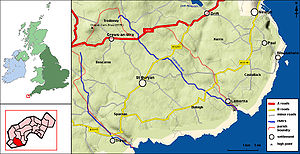
Walkfo: Visit St Buryan Places Map
39 tourist, history, culture & geography spots
St Buryan historic spots | St Buryan tourist destinations | St Buryan plaques | St Buryan geographic features |
| Walkfo St Buryan tourism map key: places to see & visit like National Trust sites, Blue Plaques, English Heritage locations & top tourist destinations in St Buryan | |||
Best St Buryan places to visit
St Buryan has places to explore by foot, bike or bus. Below are a selection of the varied St Buryan’s destinations you can visit with additional content available at the Walkfo St Buryan’s information audio spots:
 | Brane Barrow Brane Barrow is a Neolithic entrance grave located near the hamlet of Brane, Cornwall, England, UK. It is considered to be one of the smallest and best preserved burial monuments in Britain. |
 | Caer Bran Caer Bran Hill Fort is an archaeological site near Sancreed and Carn Euny Iron Age village, on the Penwith peninsula in Cornwall. |
| Sancreed Beacon Sancreed Beacon is a Bronze Age archaeological site on the Penwith peninsula of Cornwall. On top of the hill are several stone cists and Bronze Age remains comprising burial mounds and the remains of the Bronze Age hut. |
 | Treen Cliff Treen Cliff is a Site of Special Scientific Interest (SSSI) located on the Penwith Peninsula in Cornwall. Part of the site, Treryn Dinas, is a Scheduled Ancient Monument consisting of a “cliff castle” with four ramparts and ditches and the Logan Rock. |
 | Castallack Round Castallack Round or Roundago is a prehistoric site in Cornwall. It is a small circular embanked enclosure, with one entrance. It dates from the late Iron Age to the early post-Roman period. |
Visit St Buryan plaques
 0
0
plaques
here St Buryan has 0 physical plaques in tourist plaque schemes for you to explore via Walkfo St Buryan plaques audio map when visiting. Plaques like National Heritage’s “Blue Plaques” provide visual geo-markers to highlight points-of-interest at the places where they happened – and Walkfo’s AI has researched additional, deeper content when you visit St Buryan using the app. Experience the history of a location when Walkfo local tourist guide app triggers audio close to each St Buryan plaque. Currently No Physical Plaques.


 Trying to encourage visitors to St Buryan?