Welcome to Visit St Albans Places
The Walkfo guide to things to do & explore in St Albans
 Visit St Albans places using Walkfo for free guided tours of the best St Albans places to visit. A unique way to experience St Albans’s places, Walkfo allows you to explore St Albans as you would a museum or art gallery with audio guides.
Visiting St Albans Walkfo Preview
It lies east of Hemel Hempstead and west of Hatfield, about 20 miles (32 km) north-north-west of central London. St Albans was the first major town on the old Roman road of Watling Street for travellers heading north and it became the Roman city of Verulamium. When you visit St Albans, Walkfo brings St Albans places to life as you travel by foot, bike, bus or car with a mobile phone & headphones.
St Albans Places Overview: History, Culture & Facts about St Albans
Visit St Albans – Walkfo’s stats for the places to visit
With 73 audio plaques & St Albans places for you to explore in the St Albans area, Walkfo is the world’s largest heritage & history digital plaque provider. The AI continually learns & refines facts about the best St Albans places to visit from travel & tourism authorities (like Wikipedia), converting history into an interactive audio experience.
St Albans history
Iron Age
The name “Verlamion” is Celtic, meaning “settlement over or by the marsh” The town was on Prae Hill, 2 km to the west of modern St Albans, now covered by the village of St Michael’s, Verulamium Park and the Gorhambury Estate.
Roman

Verulamium was the second-largest town in Roman Britain after Londinium. It was granted the rank of municipium around AD 50, meaning that its citizens had what were known as “Latin Rights”, a lesser citizenship status than a colonia. It grew steadily; by the early 3rd century, it covered an area of about 125 acres (0.51 km), behind a deep ditch and wall.
Anglo-Saxon
St Albans Abbey and the associated Anglo-Saxon settlement were founded on the hill outside the Roman city where it was believed St Alban was buried. After the Roman withdrawal the town became the centre of the territory or regio of the Waeclingas tribe. An archaeological excavation in 1978 failed to find Roman remains on the site of the medieval chapter house.
Medieval

The medieval town grew on the hill to the east of Wæclingacaester where the Benedictine Abbey of St Albans was founded by Ulsinus in 793. There is some evidence that the original site was higher up the hill than the present building, which was begun in 1077. The scribe Matthew Vickers lived there and the first draft of Magna Carta was drawn up there. Two battles of the Wars of the Roses took place in or near the town.
Modern

Before the 20th century St Albans was a rural market town, a Christian pilgrimage site, and the first coaching stop of the route to and from London. Its population grew more slowly than London, 8–9% per decade between 1801 and 1861. In 1877 Queen Victoria issued the second royal charter, which granted city status to the borough. In the inter-war years it became a centre for the electronics industry.
St Albans geography / climate
Climate
St Albans has an oceanic climate (Köppen climate classification Cfb) similar to most of the United Kingdom. The city has a climate similar to the rest of the UK.
Neighbourhoods
Batchwood Bernards Heath Chiswell Green Cell Barnes Cottonmill. Marshalswick (also extends into Sandridge parish) New Greens Sopwell St Julians St Stephens (not to be confused with St Stephen)
Nearby towns and villages

Other nearby towns: Borehamwood, Luton, Stevenage, Berkhamsted, Barnet (historically a separate town, a London borough since the 1960s) Nearby villages: Abbots Langley, Kings Langley and Bricket Wood.
Why visit St Albans with Walkfo Travel Guide App?
 You can visit St Albans places with Walkfo St Albans to hear history at St Albans’s places whilst walking around using the free digital tour app. Walkfo St Albans has 73 places to visit in our interactive St Albans map, with amazing history, culture & travel facts you can explore the same way you would at a museum or art gallery with information audio headset. With Walkfo, you can travel by foot, bike or bus throughout St Albans, being in the moment, without digital distraction or limits to a specific walking route. Our historic audio walks, National Trust interactive audio experiences, digital tour guides for English Heritage locations are available at St Albans places, with a AI tour guide to help you get the best from a visit to St Albans & the surrounding areas.
“Curated content for millions of locations across the UK, with 73 audio facts unique to St Albans places in an interactive St Albans map you can explore.”
Walkfo: Visit St Albans Places Map
73 tourist, history, culture & geography spots
St Albans historic spots | St Albans tourist destinations | St Albans plaques | St Albans geographic features |
| Walkfo St Albans tourism map key: places to see & visit like National Trust sites, Blue Plaques, English Heritage locations & top tourist destinations in St Albans | |||
Best St Albans places to visit
St Albans has places to explore by foot, bike or bus. Below are a selection of the varied St Albans’s destinations you can visit with additional content available at the Walkfo St Albans’s information audio spots:

Royal National Rose Society Gardens
The Royal National Rose Society Gardens, also known as The Gardens of The Rose, were the gardens and headquarters of The Royal. National. Rose Society was established in 1876. The gardens contain 2,500 different rose cultivars among 15,000 rose bushes. The Gardens are permanently closed.

Watercress Wildlife Site
Watercress Wildlife Site is a 1.2-hectare (3.0-acre) Local Nature Reserve in St Albans, Hertfordshire. The site was one of the many commercial watercress beds in the area. It was then used partly as allotments, with fly tipping in some areas.

Hill End Hospital
Hill End Hospital was a mental health facility in St Albans, Hertfordshire, England. It was established in the 1950s and 1960s.

Campaign for Real Ale
Campaign for Real Ale (CAMRA) is an independent voluntary consumer organisation. It promotes what they designate as “real” ale, cider, and traditional British pubs and clubs. With just over 160,000 members, it is the largest single issue consumer group in the UK.
![]()
Sandridge Rovers F.C.
Sandridge Rovers Football Club are based in Sandridge, Hertfordshire. They currently play in the Herts County League Premier Division. They play their home matches at the Spencer Recreation Ground.
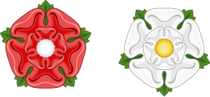
Second Battle of St Albans
The Second Battle of St Albans took place in 1461 during the Wars of the Roses. The Yorkist faction attempted to bar the road to London north of the town. The Lancastrian army used a wide outflanking manoeuvre to take the Earl of Warwick by surprise.
Sandridge Lychgate
Sandridge Lychgate is a war memorial in the village of Sandridge, Hertfordshire. It records the names of the community’s 24 fallen soldiers and also those of survivors of World War I.

The White Lion, St Albans
The White Lion is a public house in St Albans, Hertfordshire, England. In 2015 the pub was owned by Punch Taverns.

The Peahen
The Peahen is a public house in St Albans, Hertfordshire, England. The pub has been managed by McMullens Brewery since 1936.

The Boot, St Albans
The Boot is a public house in St Albans, Hertfordshire, UK. Located in the centre of the city, it is near the site of the First Battle of St. Albans. It was known as the Old Wellington pub formerly the Blue Boar.
Visit St Albans plaques
 11
11
plaques
here St Albans has 11 physical plaques in tourist plaque schemes for you to explore via Walkfo St Albans plaques audio map when visiting. Plaques like National Heritage’s “Blue Plaques” provide visual geo-markers to highlight points-of-interest at the places where they happened – and Walkfo’s AI has researched additional, deeper content when you visit St Albans using the app. Experience the history of a location when Walkfo local tourist guide app triggers audio close to each St Albans plaque. Explore Plaques & History has a complete list of Hartlepool’s plaques & Hartlepool history plaque map.


 Trying to encourage visitors to St Albans?