Welcome to Visit Springside, North Ayrshire Places
The Walkfo guide to things to do & explore in Springside, North Ayrshire
 Visit Springside, North Ayrshire places using Walkfo for free guided tours of the best Springside, North Ayrshire places to visit. A unique way to experience Springside, North Ayrshire’s places, Walkfo allows you to explore Springside, North Ayrshire as you would a museum or art gallery with audio guides.
Visiting Springside, North Ayrshire Walkfo Preview
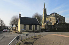
Springside is in North Ayrshire, Parish of Dreghorn, Scotland . It is three miles (five kilometres) from Irvine, 1+1/2 miles (2.5 kilometres) west of Crosshouse . In the 18th, 19th and mid-20th centuries, the locality was a highly industrialised coal mining district . When you visit Springside, North Ayrshire, Walkfo brings Springside, North Ayrshire places to life as you travel by foot, bike, bus or car with a mobile phone & headphones.
Springside, North Ayrshire Places Overview: History, Culture & Facts about Springside, North Ayrshire
Visit Springside, North Ayrshire – Walkfo’s stats for the places to visit
With 24 audio plaques & Springside, North Ayrshire places for you to explore in the Springside, North Ayrshire area, Walkfo is the world’s largest heritage & history digital plaque provider. The AI continually learns & refines facts about the best Springside, North Ayrshire places to visit from travel & tourism authorities (like Wikipedia), converting history into an interactive audio experience.
Springside, North Ayrshire history
The name Kirkland is marked on Timothy Pont’s map of 1604 and on Armstrong’s 1775 map. The name infers church ownership, possibly through a feudal grant of land by a local baron. The entire parish of Dreghorn belonged in the 12th century to the De Morvilles, Lord High Constables of Scotland.
Thorntoun Estate
Thorntoun was home to various families, such as the Montgomerys, Rosses, Mures, Cuninghames, Peebles, Wreys and Sturrocks . The house itself was demolished shortly after the Second World War and a new building constructed .
Warwickhill Estate
Warwickhill estate was situated towards the Overtoun Miners’ Row . Farms with the name Warwickdale and Warwickhill are still extant . “Warrix” is the origin of this otherwise seemingly very English-sounding name .
The Craig Estate
The Craig estate of the Dunlop family and later the Pollok-Morris family lies within the ancient Barony of Robertoun . The present Craig House, further up the hill, dates from c1780 and was enlarged c1835 and a portico and perron added by Kilmarnock architect James Ingram . The Pollok Morris family sold the house after WWII to Glasgow Corporation for use as a residential school or ‘respite home’ for Glasgow boys and later girls .
The collieries, coal pits and tileworks
The 1860, 1898–1904 and, 1911 and 1912 OS maps all show the extent to which Springside was surrounded by collieries, coal pits and freight only railway or ‘tram’ lines . Collieries were located near Cauldhame farm, Bankhead, Springhill (Pit No.4), Bankhead (one called West Thorntoun), Springhill and Springhill at Springhill, and another between Busbiehill and Warwickhill . Muirside pit was situated near to the Kirkland miners’ row .
Miner’s rows
Springside had many rows built by the mine owners for their workers . Corsehill, Sprigside and Bankhead were constructed by J & R. Howie, Archibald Finnie & Sons and A. Kenneth & Sons . Others rows were at nearby Overtoun, also Warwickhill row, and Kirkland row .
The railway

Springside railway station or Halt opened in 1890, and closed permanently to passengers on 6 April 1964 . The station never had any freight facilities and trains ran from Kilmarnock to Ardrossan where they connected with Clyde coast steamer services to Arran and Millport .
The turnpike
Springside was on a toll road or turnpike . The name ‘turnpike’ originated from the original ‘gate’ used being a simple wooden bar attached at one end to a hinge on a supporting post . The hinge allowed it to ‘open’ or ‘turn’
Farms
Springhill farm no longer exists, being situated where the main road houses are now . Springside farm is still surrounded by open fields and Kirkland farm is just across the Garrier Burn on the road to Busbiehill .
Springside primary school
Local primary school was threatened with closure by North Ayrshire Council in 2008 . Staff, pupils, parents and local people launched a vigorous campaign to save it .
Why visit Springside, North Ayrshire with Walkfo Travel Guide App?
 You can visit Springside, North Ayrshire places with Walkfo Springside, North Ayrshire to hear history at Springside, North Ayrshire’s places whilst walking around using the free digital tour app. Walkfo Springside, North Ayrshire has 24 places to visit in our interactive Springside, North Ayrshire map, with amazing history, culture & travel facts you can explore the same way you would at a museum or art gallery with information audio headset. With Walkfo, you can travel by foot, bike or bus throughout Springside, North Ayrshire, being in the moment, without digital distraction or limits to a specific walking route. Our historic audio walks, National Trust interactive audio experiences, digital tour guides for English Heritage locations are available at Springside, North Ayrshire places, with a AI tour guide to help you get the best from a visit to Springside, North Ayrshire & the surrounding areas.
“Curated content for millions of locations across the UK, with 24 audio facts unique to Springside, North Ayrshire places in an interactive Springside, North Ayrshire map you can explore.”
Walkfo: Visit Springside, North Ayrshire Places Map
24 tourist, history, culture & geography spots
Springside, North Ayrshire historic spots | Springside, North Ayrshire tourist destinations | Springside, North Ayrshire plaques | Springside, North Ayrshire geographic features |
| Walkfo Springside, North Ayrshire tourism map key: places to see & visit like National Trust sites, Blue Plaques, English Heritage locations & top tourist destinations in Springside, North Ayrshire | |||
Best Springside, North Ayrshire places to visit
Springside, North Ayrshire has places to explore by foot, bike or bus. Below are a selection of the varied Springside, North Ayrshire’s destinations you can visit with additional content available at the Walkfo Springside, North Ayrshire’s information audio spots:
 | Dreghorn Dreghorn is a village in North Ayrshire, Scotland, on the old main road from Irvine to Kilmarnock . It is sited on a ridge between two rivers and is 3.5km east of Irvine town centre . Archaeological excavations have found a significant neolithic settlement dated to around 3500 BC . |
 | Bourtreehill Bourtreehill is a large housing estate built by the Irvine Development Corporation in the late 1970s . It is part of the Irvine New Town in North Ayrshire, Scotland . Along its southern border runs the Broomlands estate . |
 | Laigh Milton Viaduct Laigh Milton Viaduct is a railway viaduct in East Ayrshire, Scotland. It was built for the Kilmarnock and Troon Railway, opened in 1812. It is the earliest known survivor of a type of multi-span railway structure subsequently adopted universally. |
Visit Springside, North Ayrshire plaques
 1
1
plaques
here Springside, North Ayrshire has 1 physical plaques in tourist plaque schemes for you to explore via Walkfo Springside, North Ayrshire plaques audio map when visiting. Plaques like National Heritage’s “Blue Plaques” provide visual geo-markers to highlight points-of-interest at the places where they happened – and Walkfo’s AI has researched additional, deeper content when you visit Springside, North Ayrshire using the app. Experience the history of a location when Walkfo local tourist guide app triggers audio close to each Springside, North Ayrshire plaque. Explore Plaques & History has a complete list of Hartlepool’s plaques & Hartlepool history plaque map.


 Trying to encourage visitors to Springside, North Ayrshire?