Welcome to Visit South Luffenham Places
The Walkfo guide to things to do & explore in South Luffenham
 Visit South Luffenham places using Walkfo for free guided tours of the best South Luffenham places to visit. A unique way to experience South Luffenham’s places, Walkfo allows you to explore South Luffenham as you would a museum or art gallery with audio guides.
Visiting South Luffenham Walkfo Preview
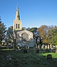
South Luffenham is a village in Rutland in the East Midlands of England. The population of the civil parish at the 2001 census was 432, increasing to 455 at the 2011 census. The village lies largely on the north side of the A6121 road from Uppingham to Stamford. It is divided into two by a stream, the Foss, which is a tributary of the River Chater. When you visit South Luffenham, Walkfo brings South Luffenham places to life as you travel by foot, bike, bus or car with a mobile phone & headphones.
South Luffenham Places Overview: History, Culture & Facts about South Luffenham
Visit South Luffenham – Walkfo’s stats for the places to visit
 With 22 audio plaques & South Luffenham places for you to explore in the South Luffenham area, Walkfo is the world’s largest heritage & history digital plaque provider. The AI continually learns & refines facts about the best South Luffenham places to visit from travel & tourism authorities (like Wikipedia), converting history into an interactive audio experience.
South Luffenham history
The village’s name means ‘homestead/village of Luffa’ Before the Second World War, the Earls of Ancaster owned all the farms and most of the cottages, except Church Farm, which belonged to the Conants. In those early days, the village was self-sufficient, having two butchers and one baker.
Why visit South Luffenham with Walkfo Travel Guide App?
 You can visit South Luffenham places with Walkfo South Luffenham to hear history at South Luffenham’s places whilst walking around using the free digital tour app. Walkfo South Luffenham has 22 places to visit in our interactive South Luffenham map, with amazing history, culture & travel facts you can explore the same way you would at a museum or art gallery with information audio headset. With Walkfo, you can travel by foot, bike or bus throughout South Luffenham, being in the moment, without digital distraction or limits to a specific walking route. Our historic audio walks, National Trust interactive audio experiences, digital tour guides for English Heritage locations are available at South Luffenham places, with a AI tour guide to help you get the best from a visit to South Luffenham & the surrounding areas.
“Curated content for millions of locations across the UK, with 22 audio facts unique to South Luffenham places in an interactive South Luffenham map you can explore.”
Walkfo: Visit South Luffenham Places Map
22 tourist, history, culture & geography spots
South Luffenham historic spots | South Luffenham tourist destinations | South Luffenham plaques | South Luffenham geographic features |
| Walkfo South Luffenham tourism map key: places to see & visit like National Trust sites, Blue Plaques, English Heritage locations & top tourist destinations in South Luffenham | |||
Best South Luffenham places to visit
South Luffenham has places to explore by foot, bike or bus. Below are a selection of the varied South Luffenham’s destinations you can visit with additional content available at the Walkfo South Luffenham’s information audio spots:
 | A47 road The A47 is a trunk road in England linking Birmingham to Lowestoft, Suffolk. Most of the section between Birmingham and Nuneaton is now classified as the B4114. |
 | St George’s Barracks, North Luffenham St George’s Barracks are a military installation near to the village of North Luffenham in Rutland. The barracks are located in the village near to a village in the area. |
 | Morcott Brook The Morcott Brook, also known locally as “The Foss”, is a small watercourse in Rutland in the East Midlands. It is a tributary of the River Chater and part of a catchment for the River Welland. |
| South Luffenham South Luffenham is a village in Rutland in the East Midlands of England. The population of the civil parish at the 2001 census was 432, increasing to 455 at the 2011 census. The village lies largely on the north side of the A6121 road from Uppingham to Stamford. It is divided into two by a stream, the Foss, which is a tributary of the River Chater. |
 | St John the Baptist’s Church, Wakerley St John the Baptist’s Church is a redundant Anglican church in the village of Wakerley, Northamptonshire. It is recorded in the National Heritage List for England as a designated Grade I listed building. |
 | St Peter’s Church, Barrowden St Peter’s Church is a Church of England parish church in Barrowden, Rutland. It is a Grade II* listed building. |
 | Church of St Mary the Virgin, Edith Weston The Church of St Mary the Virgin is a Grade I listed building in Rutland. It is a church in Edith Weston, Rutland, which was built in the 1930s. |
Visit South Luffenham plaques
 0
0
plaques
here South Luffenham has 0 physical plaques in tourist plaque schemes for you to explore via Walkfo South Luffenham plaques audio map when visiting. Plaques like National Heritage’s “Blue Plaques” provide visual geo-markers to highlight points-of-interest at the places where they happened – and Walkfo’s AI has researched additional, deeper content when you visit South Luffenham using the app. Experience the history of a location when Walkfo local tourist guide app triggers audio close to each South Luffenham plaque. Currently No Physical Plaques.


 Trying to encourage visitors to South Luffenham?