Visit South Lanarkshire Place – things to do & explore
 Visit South Lanarkshire places on a day-trip, weekend away or holiday – and Walkfo becomes your personal digital tour guide to South Lanarkshire things to do.
Visiting South Lanarkshire Overview
South Lanarkshire (Scots: Sooth Lanrikshire) is one of 32 unitary authorities of Scotland . It borders the south-east of the City of Glasgow and contains some of Greater Glasgow’s suburban towns . It also shares borders with Dumfries and Galloway, East Ayrshire, East Renfrewshire, North Lanarksshire, Scottish Borders and West Lothian .
When you visit South Lanarkshire, South Lanarkshire history becomes available at the places you travel to by foot, bike, bus or car with a mobile phone & headphones.
South Lanarkshire places overview by Walkfo
Visit to South Lanarkshire stats
With 247 tourism audio plaques & places for you to explore in South Lanarkshire, Walkfo is the world’s largest heritage & history digital plaque provider in the world. Our AI continually learns & refines content about the best South Lanarkshire places to visit from online information authorities like Wikipedia for current & history, and converts it into an audio experience.
When you visit South Lanarkshire
You can visit South Lanarkshire places and use Walkfo South Lanarkshire to discover the history & things to do in South Lanarkshire whilst walking with our free digital tour app. Walkfo South Lanarkshire has 247 places on our South Lanarkshire map with history, culture & travel facts that you explore the same way you would at a museum or art gallery with information audio headset. With Walkfo, you can travel by foot, bike or bus throughout South Lanarkshire, being in the moment, without digital distraction or limits to a specific walking route – you choose where you want to go, when you want to go and Walkfo South Lanarkshire will keep up.
–
With millions of places including tourist walks, South Lanarkshire travel destinations, National Trust locations converted to audio experiences, our South Lanarkshire places AI guide will help you get the best from your visit to South Lanarkshire & the surrounding areas. The South Lanarkshire places app for iPhone & Android delivers hidden history, interesting culture and amazing facts in interactive audio stories in response to where you walk at National Heritage sites, tourist attractions, historic locations or city streets, with no predefined walk map requirements.
“The Walkfo AI has curated content for millions of locations across the UK, with 247 audio facts unique to South Lanarkshire places forming an interactive South Lanarkshire map for you to explore.”
Walkfo’s Visit South Lanarkshire Places Map
247 tourist, history, culture & geography spots
South Lanarkshire historic spot | South Lanarkshire tourist destination | South Lanarkshire plaque | South Lanarkshire geographic feature |
| Walkfo South Lanarkshire tourism map key: places to see & visit like National Trust sites, Blue Plaques, English Heritage locations & top tourist destinations in South Lanarkshire | |||
Best South Lanarkshire places to visit
South Lanarkshire has many places to explore by foot, bike or bus. Below are a selection of the varied South Lanarkshire’s destinations you can visit with additional content available at the Walkfo South Lanarkshire’s information audio spots:
 | Burnside railway station Burnside railway station serves the Burnside and Blairbeth areas of the Royal Burgh of Rutherglen, South Lanarkshire, Greater Glasgow, Scotland . The station is located on the Newton branch of the Cathcart Circle Lines, which has been electrified since 1962 by British Railways . |
 | A71 road The A71 is a major road in Scotland linking Edinburgh with Lanarkshire and Ayrshire. Formerly a trunk route from the east to the west coast of Scotland it has since been downgraded to a mix of primary and secondary routes. From Edinburgh to Darvel, it is now a secondary route, in a poor state of repair in some places. |
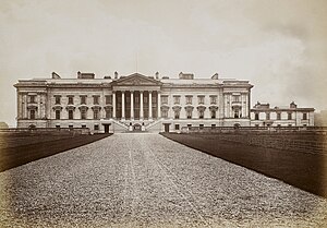 | Hamilton Palace Hamilton Palace was a country house in Hamilton, South Lanarkshire, Scotland. The former seat of the Dukes of Hamilton, it dated from the 14th century and was enlarged in the 17th and 19th centuries. The palace was demolished between 1921 and 1926. |
 | Hamilton Barracks Hamilton Barracks was a military installation in Hamilton, South Lanarkshire. It was located in the south-east of Scotland. It is located on the outskirts of Glasgow. |
| Hamilton West railway station Hamilton West railway station serves the Hamilton West area of Hamilton, South Lanarkshire, in Scotland, lying on the Argyle Line. It is situated next to New Douglas Park, home to Hamilton Academical Football Club. The station is operated by Abellio ScotRail who provide all passenger services. |
| Hamilton Park Racecourse Hamilton Park Racecourse is a thoroughbred horse racing venue in Hamilton, Scotland. Racing has been staged in Hamilton since 1782 and it is now part of Scotland’s great sporting heritage. The present racecourse opened in 1926 and since 1973 it has been owned by the Hamilton Park Trust. |
 | Chatelherault Country Park Chatelherault Country Park is a country park in Hamilton, South Lanarkshire, Scotland. Its name is derived from the French town of Châtellerault. The country park is centred on the former hunting lodge, a folly designed to be seen from the now demolished Hamilton Palace. The lodge was designed by William Adam and completed in 1734. |
 | Cadzow Castle Cadzow Castle was constructed between 1500 and 1550 at a site one mile south-east of the centre of Hamilton, South Lanarkshire, Scotland. The castle sits above a gorge overlooking the Avon Water in what is now Chatelherault Country Park, but was previously the hunting grounds of the Duke of Hamilton’s estate of Hamilton Palace. |
| Woodhead, Hamilton, Scotland Woodhead in Hamilton, South Lanarkshire lies south of Little Earnock and north of Meikle Earnock. The main area in Woodhead is Woodhead Green. The houses are largely local authority homes probably around 40–50 years old. |
| Battle of Bothwell Bridge Battle of Bothwell Bridge, or Bothwell Brig, took place on 22 June 1679. It was fought between government troops and militant Presbyterian Covenanters. The battle signalled the end of their brief rebellion. |
Visit South Lanarkshire plaques
 15
15
plaques
here South Lanarkshire has 15 physical plaques within tourist plaque schemes for you to explore via Walkfo South Lanarkshire plaques when visiting. Plaque schemes such as National Heritage’s “Blue Plaques” provide visual geo-markers to highlight points-of-interest at the places where they happened. Where a plaque is available, Walkfo AI has done research to provide additional, deeper content when you visit South Lanarkshire using the app. Experience hidden history & stories at each location as the Walkfo local tourist guide app uses trigger audio close to each South Lanarkshire plaque. Explore South Lanarkshire Plaques & History has a complete list of Hartlepool’s plaques & Hartlepool history plaque map.


 Trying to encourage visitors to South Lanarkshire?