Visit South Gloucestershire Place – things to do & explore
 Visit South Gloucestershire places on a day-trip, weekend away or holiday – and Walkfo becomes your personal digital tour guide to South Gloucestershire things to do.
Visiting South Gloucestershire Overview
South Gloucestershire is a unitary authority area in South West England . It comprises multiple suburban areas to the north and east of Bristol as well as a large rural hinterland . It was created in 1996 from the northern section of the county of Avon, which was abolished at that time .
When you visit South Gloucestershire, South Gloucestershire history becomes available at the places you travel to by foot, bike, bus or car with a mobile phone & headphones.
South Gloucestershire places overview by Walkfo
Visit to South Gloucestershire stats
 With 223 tourism audio plaques & places for you to explore in South Gloucestershire, Walkfo is the world’s largest heritage & history digital plaque provider in the world. Our AI continually learns & refines content about the best South Gloucestershire places to visit from online information authorities like Wikipedia for current & history, and converts it into an audio experience.
South Gloucestershire history
The area that now forms South Gloucestershire formed part of the shire county of Gloucesterhire. However, under the terms of the Local Government Act 1972, the area was removed from Gloucetershire, and became part of Avon, forming the districts of Kingswood and Northavon. In 1996, the unitary authority area was created as a unitary area. The area borders the city and county of Bristol, Bath and North East Somerset unitary areas, plus the shires counties of Gloucester and Wiltshire.
South Gloucestershire geography / climate
The River Severn forms the north-western edge of the area, with a wide coastal plain terminated by an escarpment. The Cotswolds Escarpment forms the eastern edge of South Gloucestershire, while the western half is mainly urbanised. South of the motorways are suburbs of Bristol while areas north are rural.
When you visit South Gloucestershire
You can visit South Gloucestershire places and use Walkfo South Gloucestershire to discover the history & things to do in South Gloucestershire whilst walking with our free digital tour app. Walkfo South Gloucestershire has 223 places on our South Gloucestershire map with history, culture & travel facts that you explore the same way you would at a museum or art gallery with information audio headset. With Walkfo, you can travel by foot, bike or bus throughout South Gloucestershire, being in the moment, without digital distraction or limits to a specific walking route – you choose where you want to go, when you want to go and Walkfo South Gloucestershire will keep up.
–
With millions of places including tourist walks, South Gloucestershire travel destinations, National Trust locations converted to audio experiences, our South Gloucestershire places AI guide will help you get the best from your visit to South Gloucestershire & the surrounding areas. The South Gloucestershire places app for iPhone & Android delivers hidden history, interesting culture and amazing facts in interactive audio stories in response to where you walk at National Heritage sites, tourist attractions, historic locations or city streets, with no predefined walk map requirements.
“The Walkfo AI has curated content for millions of locations across the UK, with 223 audio facts unique to South Gloucestershire places forming an interactive South Gloucestershire map for you to explore.”
Walkfo’s Visit South Gloucestershire Places Map
223 tourist, history, culture & geography spots
South Gloucestershire historic spot | South Gloucestershire tourist destination | South Gloucestershire plaque | South Gloucestershire geographic feature |
| Walkfo South Gloucestershire tourism map key: places to see & visit like National Trust sites, Blue Plaques, English Heritage locations & top tourist destinations in South Gloucestershire | |||
Best South Gloucestershire places to visit
South Gloucestershire has many places to explore by foot, bike or bus. Below are a selection of the varied South Gloucestershire’s destinations you can visit with additional content available at the Walkfo South Gloucestershire’s information audio spots:
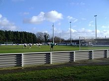 | Yate Town F.C. Yate Town Football Club is a football club based in Yate, Gloucestershire, England . They are currently members of the Southern League Premier Division South and play at Lodge Road . |
 | Chipping Sodbury Town F.C. Chipping Sodbury Town Football Club is a football club based in South Gloucestershire . They are currently members of the Hellenic League Premier Division and play at the Ridings . |
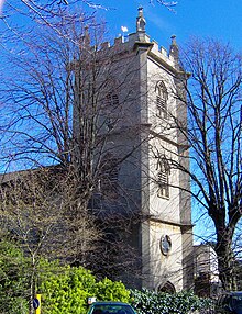 | Holy Trinity Church, Kingswood Holy Trinity Church is an Anglican parish church in Kingswood, South Gloucestershire. It has been designated as a grade II* listed building. |
| Cadbury Heath F.C. Cadbury Heath Football Club is a football club based in South Gloucestershire, England. Affiliated to the Gloucesterhire County FA, they are currently members of the Western League Premier Division and play at Springfield. |
| Oldland Abbotonians F.C. Oldland Abbotonians Football Club is a semi-professional football club based in Oldland Common South Gloucestershire, England. They are currently members of the Western League Division One and play at the Aitchison Playing Fields. |
 | North Fringe of Bristol The North Fringe of Bristol lies between the M4 and M5 motorways. Its eastern edge is usually defined as the M32 motorway. The area falls within South Gloucestershire Council, and is northern part of Greater Bristol. |
 | MoD Abbey Wood MoD Abbey Wood is a Ministry of Defence establishment at Filton, Bristol, United Kingdom. It was opened by Queen Elizabeth II in July 1996. 15 government departments employing some 13,400 people relocated to the site. |
 | Bitton Bitton is a village and civil parish of South Gloucestershire in England. It is to the east of the Greater Bristol area on the River Boyd. The parish of Bitton has a population of 9,307. |
 | Page Park, Staple Hill Page Park is a park in the Staple Hill area of South Gloucestershire. In 1910, the park was donated to the people by Arthur William Page, the same year he was elected Alderman of the county. The park has a selection of sports fields, accommodating football and cricket teams. It was the start and finish place for the Kingswood Festival marathon in 1985. |
 | St John the Baptist, Frenchay St John the Baptist is a church in the Frenchay area of Bristol, England. It was built in the 18th century. It is located in Frenchay, Bristol, and is located on the outskirts of Bristol. |
Visit South Gloucestershire plaques
 3
3
plaques
here South Gloucestershire has 3 physical plaques within tourist plaque schemes for you to explore via Walkfo South Gloucestershire plaques when visiting. Plaque schemes such as National Heritage’s “Blue Plaques” provide visual geo-markers to highlight points-of-interest at the places where they happened. Where a plaque is available, Walkfo AI has done research to provide additional, deeper content when you visit South Gloucestershire using the app. Experience hidden history & stories at each location as the Walkfo local tourist guide app uses trigger audio close to each South Gloucestershire plaque. Explore South Gloucestershire Plaques & History has a complete list of Hartlepool’s plaques & Hartlepool history plaque map.


 Trying to encourage visitors to South Gloucestershire?