Welcome to Visit Solihull Places
The Walkfo guide to things to do & explore in Solihull
 Visit Solihull places using Walkfo for free guided tours of the best Solihull places to visit. A unique way to experience Solihull’s places, Walkfo allows you to explore Solihull as you would a museum or art gallery with audio guides.
Visiting Solihull Walkfo Preview
Solihull is situated on the River Blythe in the Forest of Arden area of Warwickshire . It is the largest town in, and seat of, the Metropolitan Borough, which has a population of 214,909 . The town has roots dating back to the 1st century BC and was formally established during the Anglo Saxon and Norman eras of British history . When you visit Solihull, Walkfo brings Solihull places to life as you travel by foot, bike, bus or car with a mobile phone & headphones.
Solihull Places Overview: History, Culture & Facts about Solihull
Visit Solihull – Walkfo’s stats for the places to visit
With 38 audio plaques & Solihull places for you to explore in the Solihull area, Walkfo is the world’s largest heritage & history digital plaque provider. The AI continually learns & refines facts about the best Solihull places to visit from travel & tourism authorities (like Wikipedia), converting history into an interactive audio experience.
Solihull history
Toponymy
Solihull’s name is commonly thought to have derived from the position of its arden stone parish church, St Alphege, on a ‘soily’ hill . The church was built on a hill of stiff red marl, which turned to sticky mud in wet weather .
Early history

The land now forming Solihull was once covered in the ancient Forest of Arden . The earliest known settlement in the area was at Berry Mound, Shirley, which was the site of an Iron Age Hill Fort . The name Shirley means either ‘a bright clearing’ or ‘a border clearing’
Anglo Saxon era
By the Anglo Saxon era, an Assart settlement known as the manor of Ulverlei, meaning ‘Wulfhere’s clearing’ had been established, with its centre north east of, Shirely . The settlement was a clearing in the Forest of Arden, with land farmed in common . After the absorption of Mercia into the rest of England, Ulverllei became the property of the Earls of the Mercia .
Early medieval era
In 1086 it was recorded that the Manor of Ulverlei was now held by Cristina, great-granddaughter of Ethelred the Unready, daughter of Edward the Exile, and sister of the last Anglo Saxon King Edgar Aetheling. Shortly after 1086, Christina entered the nunnery of Romsey Abbey in Hampshire. Her lands were granted to the Norman Ralph de Limesy. The extent of the area historically considered the manor of Ulverlei is demarked by an area called ‘Worlds End’, a historical naming practice indicating that people did not live beyond there. It was between 1170 and 1180 that the de Limsey family founded the settlement of ‘Solihull’ as a “planted borough” or planned village to the south of Ulverli. It was called a borough simply because the de Limsey Lord of the Manor offered free burgage tenure where residents were free, rent-paying burgesses, rather than villeins owing service to the Lord of the Manor. By the time of Edward I, Ulverlie was sub-infeudated into the newly created Manor of Solihull, and became known as the ‘Old Town’, contracted to its present name, Olton to distinguish itself from the New Town of Solihull. The de Limsey family held the Manor of Solihull, until Ralph’s great grand daughter married Hugh de Odingsells, whose family were thought to be of Flemish origin. The Odingsells were the Lords of the Manor of Ulverley, and later after its subinfeudation, Solihull, from the 12th century and are believed to have constructed a castle on the site now known as Hobs Moat (a possible corruption of Odingsells’ Moat). The castle was occupied until around the 14th century. The Odingsells were relatives of the powerful Clinton Earls of Huntingdon of Maxstoke Castle (around 8 miles north east of Hobs Moat), whose relatives would also found nearby Kenilworth Castle (around 13 miles south east of Hobs moat) and Baddesley Clinton (around 8 miles south of Hobs Moat). The red sandstone parish church of St. Alphege dates from a similar period to Hobs Moat and is a large and handsome example of English Gothic church architecture, with a traditional spire 168 feet (51 metres) high, making it visible from a great distance. It is located at the head of High Street and is a Grade I listed building. It was founded in about 1220 by Hugh de Oddingsell. A chantry chapel was also founded there by Sir William de Oddingsell in 1277 and the upper chapel in St Alphege was built for a chantry. By 1242 the Manor of Solihull was granted a Royal charter to hold a weekly market and an annual fair “on the vigil, the feast and the morrow of St Alphege” (18-20 April). It was around this time that Solihull became a hub for its surrounding parishes. The town of Solihull would later absorb the nearby settlement of Longdon. The first recorded reference to Longdon was in 1086 as ‘Langedone’, meaning the ‘long hill’. The ‘long hill’ in question was the hill on what is now Solihull’s Marsh Lane and Yew Tree Lane, leading from the River Blythe up onto Elmdon Heath. The Longdon Manor House was at its edge on Copt Heath. In 1161 the Manor of Longdon had been property of Ketelberne de Langdon, who founded Henwood Priory and gave his name to the settlement of Catherine-de-Barnes (a corruption of the name Ketelberne). The assimilation of Longdon into Solihull was so total that few references exist today indicating it was ever a separate place. The Longdon area bordered onto the settlement of Hampton in Arden, appearing in the Domesday Survey of 1086 as ‘Hantone’. Despite bordering Solihull, Hampton in Arden would not be incorporated into the borough of Solihull until later. From the middle of the 12th century Hampton in Arden was owned by the de Arden family, and also included the then hamlet of Knowle. Knowle would become a royal manor in 1285 when the de Arden family sold it to King Edward I and Queen Eleanor. In 1396, Walter Cook applied for a faculty to build a church in ‘Knoll’, so the villagers would no longer have to cross the treacherous waters of the river Blythe to get to church, and this was granted by Pope Boniface IX on 4 May 1396. By 1402 the church was consecrated and Knowle broke away from Hampton in Arden, later becoming part of the borough of Solihull. Near Knowle lies the settlement of Temple Balsall, part of the borough of Solihull, that was founded by the Knights Templar, who farmed about 650 acres (2.6 km) of the estate in the 12th century, and established the church and the Balsall Preceptory.
Later medieval era

By 1295 the Manor of Solihull had passed from the Odingsells via heiress to the de Birmingham family . The Despencers found themselves at odds with the Trussell family of nearby Nuthurst during the baronial revolt under Edward II . By the 14th century the town had become famed for its blacksmiths .
Early modern era

Solihull was owned by the Throckmorton family of Coughton Court during the Gunpowder Plot of 1583 . The Greswolde family owned the Malvern part of Longdon Manor and Hillfields since 1311, when Thomas Hawes, a lawyer, purchased Hillfield Hall in 1576, a grand Tudor hall with battlements and a long gallery . In 1604 the family sold the Manor to Edmund Hawes who lived there until his death in 1611 .
Modern era
In the modern era, Solihull became quieter, with textile working and iron working still prominent in the town. By the 1700s work was underway on Malvern Hall, with Humphrey Greswolde overseeing, it would be completed in the first half of the century. In 1809 the hall would be painted by John Constable, for his patron, Henry Greswolde Lewis. The Greswoldes would later sell the house to Solihull council who converted the estate into Malvern Park. The hall is today part of Solihull School. Also constructed in 1712 was Touchwood Hall at the end of Dury Lane on Teinters Green. The hall would serve as the home of the Holbeche family, former lords of the manor at Widney Manor and a prominent local family. The hall would later be held by the Madeley and Martineau families. The hall was demolished in 1963 but lends its name to Solihull’s famous shopping centre. During this time poets William Shenstone and Richard Jago attended Solihull School, where today, two houses are named after them. In 1775 Monkspath Hall would be constructed, which would capture the nations media attention two centuries later when it was illegally demolished, sparking a court case which demanded it be put back exactly as it was. In the early 1800s Isaac William Lillingston sold the Manor of Hampton in Arden to former Prime Minister, and founder of the modern police force, Sir Robert Peel. Peel and his son Sir Frederick Peel modernised and made improvements to Hampton in Arden, including the construction of a new manor house, (which is today the Michelin starred Peel’s Restaurant). In 1785 the Earl of Aylesford would help found, and become patron, of the Woodmen of Arden. This is a prestigious society of Toxophilites who meet to shoot longbows at their ground in the Forest of Arden in Meriden, in the borough of Solihull. The Woodmen target shoot at only one distance, 100 yards and score in the Archers disfavour. Archery had always been an important sport in Solihull. On the doorway of the church of St Alphage are incisions which are arrow sharpening marks from the 1360s when men were required to practice archery on a Sunday to ensure a ready supply of archers. The long marks have been made by Broadheads, the round by Bodkins – types of arrowheads used with the long bows of the time. The society is strictly limited to a membership of 80, with this rule only having been bent once, when in 1835 Prime Minister Sir Robert Peel, Lord of the Manor of Hampton in Arden, was added. It was during the early 1800s that abolitionist William Wilberforce moved to the Elmdon area of Solihull following his marriage to Barbara Spooner, of the Spooner banking family who were the owners of Elmdon hall The manor of Longdon came to Lord Byron in 1815 by his marriage with Anne, daughter of Sir Ralph Milbanke Noel, and on her death in 1860 passed to her grandson the Earl of Lovelace. Two roads in Solihull are named after the family, Lady Byron Lane and Lovelace Avenue. Longdon Hall, with its remaining manorial rights, was later bought by a solicitor, Mr. J. B. Clarke of Birmingham in 1899 and soon afterwards sold to Mr. Alfred Lovekin, a silversmith. Mr Lovekin also leased land near Solihull town centre from the Chattock family of Castle Bromwich, on which he built the Jacobean style Tudor Grange Hall. After Mr Lovekin’s death, Tudor Grange Hall was sold to Sir Alfred Bird, 1st Baronet, a chemist and politician, who would later leave the land for creation of a Tudor Grange grammar school and Tudor Grange Park. Longdon hall was eventually sold to a nearby golfcourse. In 1868 George Muntz of nearby Umberslade, a campaigner for suffrage and friend of Thomas Attwood, would become the owner of the manor of Widney Manor. He would also later buy land in Bentley Heath and develop the Solihull area of Dorridge. In the 1870s the Hobday family would construct Monkspath Priory. The property would later serve Solihull as the Regency Club, a gentlemen’s club and banqueting complex, before becoming a hotel in the late 20th century. In 1898 the Fowlers Cheese company – the oldest cheese manufacturer in England, founded 1670 – moved to its current site in Earlswood. In the 1890s famed pen manufacturer Joseph Gillott constructed New Berry Hall outside Catherine de Barnes. The architect of the hall was J. A. Chatwin who designed the Victoria Tower in the Houses of Parliament. Around this time Chatwin also designed School House at Solihull School. Towards the end of this era telephone and postal services came to the town. It was said the post office in Castle Bromwich, later part of the borough of Solihull, was one of the first locations to have a telephone installed outside of London. The purported reason for this is that in 1876 Prime Minister Benjamin Disraeli was visiting, supposedly to court Lady Bradford at Castle Bromwich Hall, and needed to be able to contact the government in London. During the Victorian era a rare fluted pillar box was installed on Dog Kennel lane. Today it is Grade II listed. The post box is designed to look like a Doric column.
20th century
Unlike major cities to the north, the Industrial Revolution largely passed Solihull and much of the rest of rural Warwickshire by, and until the 20th century Solihull remained a small market town. Local population growth was due to a number of factors, perhaps most significantly, the release of large tracts of land for housing development attracting inward migration of new residents from across the United Kingdom. In 1894, Solihull (including the parishes of Shirley, Baddesley Clinton, Barston, Lapworth, Balsall, Bushwood, Elmdon, Knowle, Nuthurst, Packwood and Tanworth-in-Arden) was made into the Solihull Rural District in the county of Warwickshire. In 1932 some of its rural areas were taken away when the RDC was succeeded by Solihull Urban District Council. Solihull School continued to grow during this period. Arthur Tolkien, father of J. R. R. Tolkien (the author of The Lord of the Rings series of books) was a pupil there during the 1860s. J. R. R. Tolkien mentioned Solihull and Solihull School in some of his letters. J. R. R. Tolkien’s son Michael would go on to teach at Solihull School in the 1950s. In 1909 Cathleen Cartland would found one of the countries first non-denominational co-educational preparatory schools – Ruckleigh School – in Solihull, many decades before others followed. Like most other parts of the UK, Solihull and its borough was impacted by the First World War. In 1914 the Army Remount Service, responsible for the nations war horses (specifically collecting horses and dispatching them on to combat areas) was headquartered in what is now the Wilson Arms in Knowle. The town and borough also provided a number of Auxiliary Hospitals. The village of Hockley Heath was bombed by a lost Zeppelin L 62. It was during the early 1900s that the poet W. H. Auden grew up in Solihull on Homer Road. In 1936 two Solihull farms were bought for the construction of a shadow factory to prepare for the Second World War. The purpose of the shadow factories were to be as secret as possible, often located in rural areas, to prevent enemy bombing. After the war in 1948, this factory would become the home of the Land Rover car company. On 8 July 1939 Prime Minister Neville Chamberlain and the Duchess of Kent opened Solihull’s airport ‘Elmdon Airport’. The Elmdon Terminal, which incorporated the airport’s air traffic control tower, is famous for having been designed by Norman and Dawbarn in an Art Deco style. Shortly after opening it would be requisitioned for the Second World War, becoming RAF Elmdon. On 8 July 1946, the aerodrome was reopened to civilian operations, though it remained under government control. In 1960 control of the airport was handed to Birmingham City Council, and the airport was renamed ‘Birmingham International Airport’. At the time despite being England’s second city, Birmingham was without an airport and Elmdon Airport in Solihull was the closest. Reflecting the fact that Birmingham Airport was in Solihull and not Birmingham, a train station called Birmingham International Rail Station was added to transport travelers the 8 mile journey into Birmingham. The airport and station are connected via Air-Rail Link. The airport is still affectionately known amongst some Solihull residents as Elmdon Airport. By the time the Second World War started Solihull had become a reception area for evacuated Children from Coventry and the East End of London. Some barrage balloons, smokescreens and searchlights were erected around Solihull in an effort to confuse any enemy bomber planes flying over head on their way to critical major industrial areas. A military convalescent hospital was opened in Tudor Grange House. A British Restaurant was opened up on Mill Lane. The town adopted the ship HMS Vivacious in 1942. In preparation for the D-Day landings, an American Army headquarters was established on Blossomfield Road. The town also had a Home Guard Battalion. In 1954 Queen Elizabeth II granted a Royal Charter of Incorporation making Solihull into a Municipal Borough; ten years later it was given the status of County Borough. Reorganisation of boundaries and council responsibilities in 1974 created the Metropolitan Borough of Solihull by the merger of the Solihull County Borough and most of the Meriden Rural District, which forms the main rural part of the borough and county. It included Balsall Common, Barston, Berkswell, Bickenhill, Castle Bromwich, Chelmsley Wood, Elmdon, Fordbridge, Hampton in Arden, Hockley Heath, Kingshurst, Knowle, Marston Green, Meriden, Olton, Smiths Wood, Solihull, Shirley and Temple Balsall. A coat of arms was granted to the borough, with a Black Griffin taken from the arms of the Earls of Aylesford of Meriden, a Silver Fleur-de-lys comes from the Digby family associated with Coleshill and Fordbridge, and a Black Greyhound taken from the arms of the Greswolds, of Solihull town. Until the early 1960s, the main high street remained much as it would have been in the late 19th century with several streets of Victorian terraced houses linking High Street with Warwick Road. The construction of the central shopping area known as Mell Square (named after W. Maurice Mell, the town clerk who planned the work) involved the demolition of properties in Mill Lane and Drury Lane, some of which were several hundred years old, together with that of the large Victorian Congregational church that had stood on the corner of Union Street and Warwick Road. In 1986 the Solihull borough effectively became a unitary authority after the abolition of the County Council. The borough is administered from a building on Church Hill in Solihull town centre. On 23 November 1981, an F0/T1 tornado touched down in nearby Shirley. The tornado later moved over Solihull town centre, causing some damage to the town centre before dissipating.
Present day

Solihull Metropolitan Borough Council is effectively a unitary authority providing the majority of local government services . West Midlands administrative functions such as policing, fire and public transport are organised through the West Midlands administrative division and combined authority .
Solihull culture & places
Screen and stage
Solihull is home to the Core Theatre and the centre of the city has a Cineworld cinema . The city centre is also home to a Cineeworld cinema and a Core Theatre . The Core Theatre is part of the Arts Complex and is a theatre complex .
Music and dance

Resorts World Arena is a multipurpose indoor arena with a capacity of 15,685 opened in 1980 with a concert by Queen . A number of internationally renowned acts have performed there in recent years, including Lady Gaga and Adele . Solihull has a symphony orchestra founded in 1990 .
Art and museums
Solihull is home to a large number of public sculptures and art works . There are also a number of museums, galleries and historic properties open to the public . Berry Mound is the site of an Iron Age hill fort dating back to the 1st century BC . The National Motorcycle Museum is the largest collection of British motorcycles in the world .
Solihull economy & business
Industry

Solihull is the home of four-wheel-drive car manufacturer Land Rover . The village of Meriden was the famous home of the Triumph motorbike factory from 1942 to 1983 . The Lucas company supplied lighting and electric components to the motorcycle and aerospace industries .
Food and beverage
Earlswood in Solihull borough is home to Fowlers, established since 1670, it is the oldest cheese-making business in England . In Catherine de Barnes is the Silhill Brewery, the former home of retail bakers Three Cooks . The Grenade Protein Bar company, valued at £200m in 2021, is based in the borough .
Service sector
The National Exhibition Centre is within the borough of Solihull, which hosts a number of national trade shows . The Blythe Valley Business Park is also within the area, with excellent links to Birmingham Airport and the M42, M40 and M6 motorways .
Third sector and charity
Royal Star and Garter Homes operates one of its three state of the art care homes in Solihull . Charity founded in 1916 to provide care for ex-Service people and their partners .
Solihull geography / climate
Solihull is located in the Forest of Arden area on the River Blythe 127 m (416 ft) above sea level. The town is 7.5 miles (12.1 km) southeast of Birmingham, 13 miles (21 km) west of Coventry, 18 miles (29 km) northwest of Warwick and 32 miles (51 km) northeast of Worcester.
Why visit Solihull with Walkfo Travel Guide App?
 You can visit Solihull places with Walkfo Solihull to hear history at Solihull’s places whilst walking around using the free digital tour app. Walkfo Solihull has 38 places to visit in our interactive Solihull map, with amazing history, culture & travel facts you can explore the same way you would at a museum or art gallery with information audio headset. With Walkfo, you can travel by foot, bike or bus throughout Solihull, being in the moment, without digital distraction or limits to a specific walking route. Our historic audio walks, National Trust interactive audio experiences, digital tour guides for English Heritage locations are available at Solihull places, with a AI tour guide to help you get the best from a visit to Solihull & the surrounding areas.
“Curated content for millions of locations across the UK, with 38 audio facts unique to Solihull places in an interactive Solihull map you can explore.”
Walkfo: Visit Solihull Places Map
38 tourist, history, culture & geography spots
Solihull historic spots | Solihull tourist destinations | Solihull plaques | Solihull geographic features |
| Walkfo Solihull tourism map key: places to see & visit like National Trust sites, Blue Plaques, English Heritage locations & top tourist destinations in Solihull | |||
Best Solihull places to visit
Solihull has places to explore by foot, bike or bus. Below are a selection of the varied Solihull’s destinations you can visit with additional content available at the Walkfo Solihull’s information audio spots:
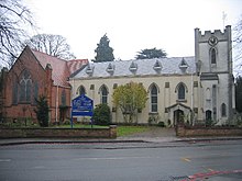
St James the Great, Shirley
St James the Great, Shirley is a Grade II listed Church of England parish in the Anglican Diocese of Birmingham. It is located in Shirley, near to the centre of Shirley, in the area of the Birmingham Diocese.
Visit Solihull plaques
 8
8
plaques
here Solihull has 8 physical plaques in tourist plaque schemes for you to explore via Walkfo Solihull plaques audio map when visiting. Plaques like National Heritage’s “Blue Plaques” provide visual geo-markers to highlight points-of-interest at the places where they happened – and Walkfo’s AI has researched additional, deeper content when you visit Solihull using the app. Experience the history of a location when Walkfo local tourist guide app triggers audio close to each Solihull plaque. Explore Plaques & History has a complete list of Hartlepool’s plaques & Hartlepool history plaque map.


 Trying to encourage visitors to Solihull?