Welcome to Visit Smithills Places
The Walkfo guide to things to do & explore in Smithills
 Visit Smithills places using Walkfo for free guided tours of the best Smithills places to visit. A unique way to experience Smithills’s places, Walkfo allows you to explore Smithills as you would a museum or art gallery with audio guides.
Visiting Smithills Walkfo Preview
Smithills lies on the lower south facing slopes of the West Pennine Moors. It is 3.1 miles (5 km) northwest of Bolton and 14.5 miles (23 km) south of Blackburn. When you visit Smithills, Walkfo brings Smithills places to life as you travel by foot, bike, bus or car with a mobile phone & headphones.
Smithills Places Overview: History, Culture & Facts about Smithills
Visit Smithills – Walkfo’s stats for the places to visit
With 59 audio plaques & Smithills places for you to explore in the Smithills area, Walkfo is the world’s largest heritage & history digital plaque provider. The AI continually learns & refines facts about the best Smithills places to visit from travel & tourism authorities (like Wikipedia), converting history into an interactive audio experience.
Smithills history
Smithills was anciently a manor in the township of Halliwell with Smithills Hall serving as the manor house. In 1877, the south-eastern area became the ninth electoral ward of the County Borough of Bolton.
Smithills toponymy
Smithills derives from the Old English smeþe meaning smooth and hyll, a hill. The name Smithills was recorded as Smythell in 1322.
Why visit Smithills with Walkfo Travel Guide App?
 You can visit Smithills places with Walkfo Smithills to hear history at Smithills’s places whilst walking around using the free digital tour app. Walkfo Smithills has 59 places to visit in our interactive Smithills map, with amazing history, culture & travel facts you can explore the same way you would at a museum or art gallery with information audio headset. With Walkfo, you can travel by foot, bike or bus throughout Smithills, being in the moment, without digital distraction or limits to a specific walking route. Our historic audio walks, National Trust interactive audio experiences, digital tour guides for English Heritage locations are available at Smithills places, with a AI tour guide to help you get the best from a visit to Smithills & the surrounding areas.
“Curated content for millions of locations across the UK, with 59 audio facts unique to Smithills places in an interactive Smithills map you can explore.”
Walkfo: Visit Smithills Places Map
59 tourist, history, culture & geography spots
Smithills historic spots | Smithills tourist destinations | Smithills plaques | Smithills geographic features |
| Walkfo Smithills tourism map key: places to see & visit like National Trust sites, Blue Plaques, English Heritage locations & top tourist destinations in Smithills | |||
Best Smithills places to visit
Smithills has places to explore by foot, bike or bus. Below are a selection of the varied Smithills’s destinations you can visit with additional content available at the Walkfo Smithills’s information audio spots:
 | Eagley Brook Eagley Brook is a small river of Lancashire and Greater Manchester. It rises at the confluence of several smaller streams at Old Man’s Hill in the West Pennine Moors. The brook feeds Belmont Reservoir and passes the village of Belmont and collects several tributaries. It flows south, through Eagley near Bromley Cross, towards Astley Bridge, after which it joins Astley Brook to form the River Tonge. |
 | Blair Hospital Blair Hospital was a health facility at Bromley Cross near Bolton, Greater Manchester. It was a very distinctive building, perhaps one of Bolton’s really well-known buildings. |
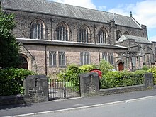
 | St Patrick’s Church, Bolton St Patrick’s Church is a Roman Catholic Church in Bolton, Greater Manchester. It was built in 1861 and is a Gothic Revival style building. It is situated on the corner of Great Moor Street and Johnson Street. |
 | Octagon Theatre, Bolton The Octagon Theatre is a producing theatre located in Bolton, Greater Manchester, England. It is located in the city of Bolton and is located on the outskirts of Manchester. |
 | Bolton Town Hall Bolton Town Hall was built between 1866 and 1873 to designs by William Hill of Leeds and George Woodhouse of Bolton. The town hall was extended in the 1930s to the designs of Bradshaw, Gass and Hope. It has been designated a Grade II* listed building by English Heritage. |
 | Bolton Market Hall Bolton Market Hall is a listed building in Bolton, Greater Manchester. The market hall and its integral ground-floor shops on Bridge Street, Corporation Street and Knowsley Street are included in the English Heritage listing. |
 | Bolton Royal Infirmary The Bolton Royal Infirmary was an acute general hospital in Bolton, Greater Manchester, England. It was a hospital in Chorley Street, Bolton. |
 | Queen’s Park, Bolton Queen’s Park is a roughly circular 22 acres (8.9 ha) Victorian park lying on sloping ground to the north-west of Bolton town centre, in Greater Manchester. Opened as Bolton Park on 24 May 1866 by Lord Bradford it was renamed in 1897 in honour of Queen Victoria’s Diamond Jubilee. |
 | Pike’s Lane Pike’s Lane was the home ground of Bolton Wanderers between 1880 and 1895. It was the venue of the first-ever goal scored in league football anywhere in the world. |
 | St Margaret’s Church, Halliwell St Margaret’s Church is in Lonsdale Road, Halliwell, Bolton, Greater Manchester. It is an active Anglican parish church in the deanery of Bolton, the archdeaconry of Bolton and the diocese of Manchester. |
Visit Smithills plaques
 9
9
plaques
here Smithills has 9 physical plaques in tourist plaque schemes for you to explore via Walkfo Smithills plaques audio map when visiting. Plaques like National Heritage’s “Blue Plaques” provide visual geo-markers to highlight points-of-interest at the places where they happened – and Walkfo’s AI has researched additional, deeper content when you visit Smithills using the app. Experience the history of a location when Walkfo local tourist guide app triggers audio close to each Smithills plaque. Explore Plaques & History has a complete list of Hartlepool’s plaques & Hartlepool history plaque map.


 Trying to encourage visitors to Smithills?