Welcome to Visit Shackleford Places
The Walkfo guide to things to do & explore in Shackleford
 Visit Shackleford places using Walkfo for free guided tours of the best Shackleford places to visit. A unique way to experience Shackleford’s places, Walkfo allows you to explore Shackleford as you would a museum or art gallery with audio guides.
Visiting Shackleford Walkfo Preview
Shackleford is a village and civil parish in the Borough of Guildford, Surrey. It is located 32 miles (51 km) southwest of London. It includes the localities of Hurtmore, Hurtmore and Gatwick. When you visit Shackleford, Walkfo brings Shackleford places to life as you travel by foot, bike, bus or car with a mobile phone & headphones.
Shackleford Places Overview: History, Culture & Facts about Shackleford
Visit Shackleford – Walkfo’s stats for the places to visit
With 40 audio plaques & Shackleford places for you to explore in the Shackleford area, Walkfo is the world’s largest heritage & history digital plaque provider. The AI continually learns & refines facts about the best Shackleford places to visit from travel & tourism authorities (like Wikipedia), converting history into an interactive audio experience.
Shackleford history
The village does not appear in the Domesday Book of 1086. The name first appears in 1220, as Sakelesford, and appears in a variety of variants thereafter. The second element, -ford, is self-explanatory, but the etymology of the “Shackle-” element is uncertain. One possibility is that it is from Old English sceacol ‘a shackle’, perhaps with reference to a chain used in crossing the river.
Shackleford landmarks
Norney Grange
Norney Grange, designed by Charles Voysey, is the highest architecturally graded listed building in the Norney part of the parish. The house features prominently in the 2021 film The Dig, standing in as Edith Pretty’s house at Sutton Hoo, Suffolk.
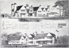
Hall Place/ Aldro School
Hall Place was demolished in 1797 and a new mansion was built on the site in the late 19th century. During the Second World War this building and much of its grounds were bought by Aldro School, which relocated there from Eastbourne.
Mitchen Hall
To the south-west is a late 17th-century two-storey galleted coursed sandstone home with red brick dressings facing its round front drive.
Anglo-Saxon fortified village and bridge
During the reign of King Alfred the Great an Anglo-Saxon burgh was constructed at Upper Eashing as a defensive point to resist Viking attacks. The bridge is officially listed as “probably built by the monks of Waverley Abbey”; it is made of local rubble stone with thin slabs of Bargate stone set in mortar.
Shackleford geography / climate
Most of the parish consists of relative uplands to the Wey Valley. Elevations vary between 102 m AOD in the north and west to 45m AOD at a weir marking the boundary.
Soil
An arc of wet heath soil is to the south-east, south, south-west, west and north-west of the village centre, covering all of Norney and Gatwick. This is the same type of heath as in Esher, Oxshott, Weybridge, Wisley, all around Woking, Brookwood, Deepcut, Pirbright, Frimley, Lightwater, Camberley, Chobham Common, Virginia Water and Ottershaw. The remainder of the soil is in common with Godalming, “free draining slightly acid loamy”
Why visit Shackleford with Walkfo Travel Guide App?
 You can visit Shackleford places with Walkfo Shackleford to hear history at Shackleford’s places whilst walking around using the free digital tour app. Walkfo Shackleford has 40 places to visit in our interactive Shackleford map, with amazing history, culture & travel facts you can explore the same way you would at a museum or art gallery with information audio headset. With Walkfo, you can travel by foot, bike or bus throughout Shackleford, being in the moment, without digital distraction or limits to a specific walking route. Our historic audio walks, National Trust interactive audio experiences, digital tour guides for English Heritage locations are available at Shackleford places, with a AI tour guide to help you get the best from a visit to Shackleford & the surrounding areas.
“Curated content for millions of locations across the UK, with 40 audio facts unique to Shackleford places in an interactive Shackleford map you can explore.”
Walkfo: Visit Shackleford Places Map
40 tourist, history, culture & geography spots
Shackleford historic spots | Shackleford tourist destinations | Shackleford plaques | Shackleford geographic features |
| Walkfo Shackleford tourism map key: places to see & visit like National Trust sites, Blue Plaques, English Heritage locations & top tourist destinations in Shackleford | |||
Best Shackleford places to visit
Shackleford has places to explore by foot, bike or bus. Below are a selection of the varied Shackleford’s destinations you can visit with additional content available at the Walkfo Shackleford’s information audio spots:

Puttenham and Crooksbury Commons
Puttenham and Crooksbury Commons is a 113.8-hectare (281-acre) biological Site of Special Scientific Interest between Farnham and Guildford in Surrey. It is owned by the Hampton Estate and managed on behalf of Surrey County Council by the Surrey Wildlife Trust. Hillbury Hillfort is a univallate hillfort which probably dates to the Iron Age.
Visit Shackleford plaques
 6
6
plaques
here Shackleford has 6 physical plaques in tourist plaque schemes for you to explore via Walkfo Shackleford plaques audio map when visiting. Plaques like National Heritage’s “Blue Plaques” provide visual geo-markers to highlight points-of-interest at the places where they happened – and Walkfo’s AI has researched additional, deeper content when you visit Shackleford using the app. Experience the history of a location when Walkfo local tourist guide app triggers audio close to each Shackleford plaque. Explore Plaques & History has a complete list of Hartlepool’s plaques & Hartlepool history plaque map.


 Trying to encourage visitors to Shackleford?