Welcome to Visit Scremerston Places
The Walkfo guide to things to do & explore in Scremerston
 Visit Scremerston places using Walkfo for free guided tours of the best Scremerston places to visit. A unique way to experience Scremerston’s places, Walkfo allows you to explore Scremerston as you would a museum or art gallery with audio guides.
Visiting Scremerston Walkfo Preview
Scremerston is 2.5 miles (4 km) south of Berwick-upon-Tweed and 4.3 miles (7 km) from the Anglo-Scottish border. It is adjacent to the A1, providing access to Newcastle upon Tyne and Edinburgh. When you visit Scremerston, Walkfo brings Scremerston places to life as you travel by foot, bike, bus or car with a mobile phone & headphones.
Scremerston Places Overview: History, Culture & Facts about Scremerston
Visit Scremerston – Walkfo’s stats for the places to visit
With 20 audio plaques & Scremerston places for you to explore in the Scremerston area, Walkfo is the world’s largest heritage & history digital plaque provider. The AI continually learns & refines facts about the best Scremerston places to visit from travel & tourism authorities (like Wikipedia), converting history into an interactive audio experience.
Scremerston history
Neolithic and Bronze Age settlements

Two cists were found in Scremerston about 110 metres (360 ft) north-west of Borewell Farm, one in 1922 the other in 1948. Evidence of habitation during this period is scarce but not insignificant.
The Iron Age and Roman-British settlements

A multivallate fort is recorded on the cliffline 1/5 mile (0.32 km) north of Seahouse. Three arcs of ditch enclose an area about 150 m across. The eastern end of the fort has not been identified and has most likely been lost to erosion. The Devil’s Causeway is a Roman road which starts at Port Gate on Hadrian’s Wall, north of Corbridge, and extends northwards across Northumberland.
Medieval settlements and border wars
Scremerston is mentioned as the home of Robert De Tughale (Tuggal), sheriff of Berwick from 1333-1337. This was a particularly violent period in the area, with Berwick having been under siege by the English for four months and finally captured in 1333. The remains of earthworks and ridge and furrow ploughing can still be seen.
Greenwich Hospital
The lands surrounding Scremerston were once held by the Radcliffe family, Earls of Derwentwater. James the last earl was beheaded for treason in 1716 following a Jacobite rebellion. The lands were granted to the Commissioners of Greenwich Hospital in 1735.
Industrialisation
Scremerston Mill was a water-powered mill designed by Leeds civil engineer John Smeaton in 1776. Corn mill was unique for having its own harbour and an unusual horizontal “norse” water wheel. Hud’s Head quarry, also known as Pier Quarry, was active between 1808 and 1825 and was the source of the stone for Berwick Pier.
World War II

Scremerston was the site of Spittal Chain Home Low radar station during World War II. The gun house sits on top of a loading platform for three limestones kilns which were still in place when the gun house was built, but later demolished by Northumberland County Council in 1981.
De-industrialisation
By the turn of the 20th century, much of Scremerston’s industry was in decline. Local coal seams were becoming exhausted and labour intensive industries such as lime production found themselves unable to compete against larger more mechanised plants elsewhere. The Blackhill Colliery continued production into the 1950s, but closed after a well documented campaign to save it in 1959.
Scremerston landmarks
Buildings

The Church of St Peter is Grade II listed and was designed and built by Ignatius Bonomi and John Augustus Cory in 1842-43 in the ‘early English style’ A Primitive Methodist chapel built in 1886 stands in the village and is now a dwelling. The remains of several lime kilns survive in the cliff faces at Cocklawburn beach.
Memorials
A war memorial was unveiled on 8 May 1920 in commemoration of 14 local servicemen who died during the First World War. The memorial is located 150m south of St Peter’s Church beside the main road. A second similar photographic memorial was dedicated after World War II.
Scremerston geography / climate
The Scremerston Formation
Scremerston Formation formed by the actions of a large river delta as well as marine deposits. Sandstones make up about 50% of the formation and are white, grey, brown or reddish brown. Mudstone layers are grey or brownish grey and non-calcareous. About 5% of formation is made up of coal seams, which reach up to 1.5 m thick.
Why visit Scremerston with Walkfo Travel Guide App?
 You can visit Scremerston places with Walkfo Scremerston to hear history at Scremerston’s places whilst walking around using the free digital tour app. Walkfo Scremerston has 20 places to visit in our interactive Scremerston map, with amazing history, culture & travel facts you can explore the same way you would at a museum or art gallery with information audio headset. With Walkfo, you can travel by foot, bike or bus throughout Scremerston, being in the moment, without digital distraction or limits to a specific walking route. Our historic audio walks, National Trust interactive audio experiences, digital tour guides for English Heritage locations are available at Scremerston places, with a AI tour guide to help you get the best from a visit to Scremerston & the surrounding areas.
“Curated content for millions of locations across the UK, with 20 audio facts unique to Scremerston places in an interactive Scremerston map you can explore.”
Walkfo: Visit Scremerston Places Map
20 tourist, history, culture & geography spots
Scremerston historic spots | Scremerston tourist destinations | Scremerston plaques | Scremerston geographic features |
| Walkfo Scremerston tourism map key: places to see & visit like National Trust sites, Blue Plaques, English Heritage locations & top tourist destinations in Scremerston | |||
Best Scremerston places to visit
Scremerston has places to explore by foot, bike or bus. Below are a selection of the varied Scremerston’s destinations you can visit with additional content available at the Walkfo Scremerston’s information audio spots:
 | Berwick Town Hall Berwick Town Hall is a municipal facility in Marygate, Berwick-upon-Tweed, England. The town hall is a Grade I listed building. |
 | Shaws Lane Chapel Shaws Lane Relief Chapel in Berwick upon Tweed was founded in 1756 by a Presbyterian group seceding from the Low Meeting House in Hide Hill. The Congregation were of the Church of Scotland but preferred to choose their own Minister. |
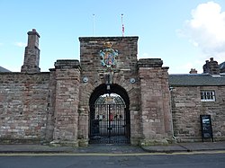 | Berwick Barracks Berwick Barracks is a former military installation of the British Army in Berwick-upon-Tweed, England. It is sometimes known as Ravensdowne Barracks. |
 | Church of the Holy Trinity, Berwick-on-Tweed The Church of the Holy Trinity, Berwick-on-Tweed is a Church of England parish church. It is a rare example of a church built in the Commonwealth era. |
 | Berwick Infirmary Berwick Infirmary is a community hospital in Berwick-upon-Tweed, Northumberland. It is managed by Northumbria Healthcare NHS Foundation Trust. |
 | East Ord East Ord is a village in Northumberland, England about 2 miles (3 km) south west of Berwick Upon Tweed. It lies on the south bank of the River Tweed adjacent to the A1 Road. |
Visit Scremerston plaques
 1
1
plaques
here Scremerston has 1 physical plaques in tourist plaque schemes for you to explore via Walkfo Scremerston plaques audio map when visiting. Plaques like National Heritage’s “Blue Plaques” provide visual geo-markers to highlight points-of-interest at the places where they happened – and Walkfo’s AI has researched additional, deeper content when you visit Scremerston using the app. Experience the history of a location when Walkfo local tourist guide app triggers audio close to each Scremerston plaque. Explore Plaques & History has a complete list of Hartlepool’s plaques & Hartlepool history plaque map.


 Trying to encourage visitors to Scremerston?