Welcome to Visit San Francisco Places
The Walkfo guide to things to do & explore in San Francisco
 Visit San Francisco places using Walkfo for free guided tours of the best San Francisco places to visit. A unique way to experience San Francisco’s places, Walkfo allows you to explore San Francisco as you would a museum or art gallery with audio guides.
Visiting San Francisco Walkfo Preview
San Francisco is the 16th most populous city in the United States, and the fourth most populous in California, with 881,549 residents as of 2019. It covers an area of about 46.89 square miles (121.4 square kilometers), mostly at the north end of the San Francisco Peninsula. San Francisco was founded on June 29, 1776, when colonists from Spain established the Presidio of San Francisco at the Golden Gate and Mission San Francisco de Asís a few miles away, both named for Francis of Assisi. The Golden Gate Bridge, cable cars, the former Alcatraz Federal Penitentiary, Fisherman’s Wharf, and its Chinatown district. When you visit San Francisco, Walkfo brings San Francisco places to life as you travel by foot, bike, bus or car with a mobile phone & headphones.
San Francisco Places Overview: History, Culture & Facts about San Francisco
Visit San Francisco – Walkfo’s stats for the places to visit
With 48 audio plaques & San Francisco places for you to explore in the San Francisco area, Walkfo is the world’s largest heritage & history digital plaque provider. The AI continually learns & refines facts about the best San Francisco places to visit from travel & tourism authorities (like Wikipedia), converting history into an interactive audio experience.
San Francisco history

The earliest archaeological evidence of human habitation of the territory of the city of San Francisco dates to 3000 BC. The Yelamu group of the Ohlone people resided in a few small villages when an overland Spanish exploration party, led by Don Gaspar de Portolá, arrived on November 2, 1769, the first documented European visit to San Francisco Bay. The first maritime presence occurred on August 5, 1775, when San Carlos—commanded by Juan Manuel de Ayala—became the first ship to anchor in the bay. The following year, on March 28, 1776, the Spanish established the Presidio of San Francisco, followed by a mission, Mission San Francisco de Asís (Mission Dolores), established by the Spanish explorer Juan Bautista de Anza. Upon independence from Spain in 1821, the area became part of Mexico. Under Mexican rule, the mission system gradually ended, and its lands became privatized. In 1835, William Richardson, a naturalized Mexican citizen of English birth, erected the first independent homestead, near a boat anchorage around what is today Portsmouth Square. Together with Alcalde Francisco de Haro, he laid out a street plan for the expanded settlement, and the town, named Yerba Buena, began to attract American settlers. Commodore John D. Sloat claimed California for the United States on July 7, 1846, during the Mexican–American War, and Captain John B. Montgomery arrived to claim Yerba Buena two days later. Yerba Buena was renamed San Francisco on January 30 of the next year, and Mexico officially ceded the territory to the United States at the end of the war in 1848. Despite its attractive location as a port and naval base, San Francisco was still a small settlement with inhospitable geography. The California Gold Rush brought a flood of treasure seekers (known as “forty-niners”, as in “1849”). With their sourdough bread in tow, prospectors accumulated in San Francisco over rival Benicia, raising the population from 1,000 in 1848 to 25,000 by December 1849. The promise of great wealth was so strong that crews on arriving vessels deserted and rushed off to the gold fields, leaving behind a forest of masts in San Francisco harbor. Some of these approximately 500 abandoned ships were used at times as storeships, saloons, and hotels; many were left to rot and some were sunk to establish title to the underwater lot. By 1851, the harbor was extended out into the bay by wharves while buildings were erected on piles among the ships. By 1870, Yerba Buena Cove had been filled to create new land. Buried ships are occasionally exposed when foundations are dug for new buildings. California was quickly granted statehood in 1850, and the U.S. military built Fort Point at the Golden Gate and a fort on Alcatraz Island to secure the San Francisco Bay. Silver discoveries, including the Comstock Lode in Nevada in 1859, further drove rapid population growth. With hordes of fortune seekers streaming through the city, lawlessness was common, and the Barbary Coast section of town gained notoriety as a haven for criminals, prostitution, and gambling. Entrepreneurs sought to capitalize on the wealth generated by the Gold Rush. Early winners were the banking industry, with the founding of Wells Fargo in 1852 and the Bank of California in 1864. Development of the Port of San Francisco and the establishment in 1869 of overland access to the eastern U.S. rail system via the newly completed Pacific Railroad (the construction of which the city only reluctantly helped support) helped make the Bay Area a center for trade. Catering to the needs and tastes of the growing population, Levi Strauss opened a dry goods business and Domingo Ghirardelli began manufacturing chocolate. Chinese immigrants made the city a polyglot culture, drawn to “Old Gold Mountain”, creating the city’s Chinatown quarter. In 1870, Asians made up 8% of the population. The first cable cars carried San Franciscans up Clay Street in 1873. The city’s sea of Victorian houses began to take shape, and civic leaders campaigned for a spacious public park, resulting in plans for Golden Gate Park. San Franciscans built schools, churches, theaters, and all the hallmarks of civic life. The Presidio developed into the most important American military installation on the Pacific coast. By 1890, San Francisco’s population approached 300,000, making it the eighth-largest city in the United States at the time. Around 1901, San Francisco was a major city known for its flamboyant style, stately hotels, ostentatious mansions on Nob Hill, and a thriving arts scene. The first North American plague epidemic was the San Francisco plague of 1900–1904. At 5:12 am on April 18, 1906, a major earthquake struck San Francisco and northern California. As buildings collapsed from the shaking, ruptured gas lines ignited fires that spread across the city and burned out of control for several days. With water mains out of service, the Presidio Artillery Corps attempted to contain the inferno by dynamiting blocks of buildings to create firebreaks. More than three-quarters of the city lay in ruins, including almost all of the downtown core. Contemporary accounts reported that 498 people lost their lives, though modern estimates put the number in the several thousands. More than half of the city’s population of 400,000 was left homeless. Refugees settled temporarily in makeshift tent villages in Golden Gate Park, the Presidio, on the beaches, and elsewhere. Many fled permanently to the East Bay. Rebuilding was rapid and performed on a grand scale. Rejecting calls to completely remake the street grid, San Franciscans opted for speed. Amadeo Giannini’s Bank of Italy, later to become Bank of America, provided loans for many of those whose livelihoods had been devastated. The influential San Francisco Planning and Urban Research Association or SPUR was founded in 1910 to address the quality of housing after the earthquake. The earthquake hastened development of western neighborhoods that survived the fire, including Pacific Heights, where many of the city’s wealthy rebuilt their homes. In turn, the destroyed mansions of Nob Hill became grand hotels. City Hall rose again in splendid Beaux Arts style, and the city celebrated its rebirth at the Panama–Pacific International Exposition in 1915. It was during this period San Francisco built some of its most important infrastructure. Civil Engineer Michael O’Shaughnessy was hired by San Francisco Mayor James Rolph as chief engineer for the city in September 1912 to supervise the construction of the Twin Peaks Reservoir, the Stockton Street Tunnel, the Twin Peaks Tunnel, the San Francisco Municipal Railway, the Auxiliary Water Supply System, and new sewers. San Francisco’s streetcar system, of which the J, K, L, M, and N lines survive today, was pushed to completion by O’Shaughnessy between 1915 and 1927. It was the O’Shaughnessy Dam, Hetch Hetchy Reservoir, and Hetch Hetchy Aqueduct that would have the largest effect on San Francisco. An abundant water supply enabled San Francisco to develop into the city it has become today. In ensuing years, the city solidified its standing as a financial capital; in the wake of the 1929 stock market crash, not a single San Francisco-based bank failed. Indeed, it was at the height of the Great Depression that San Francisco undertook two great civil engineering projects, simultaneously constructing the San Francisco–Oakland Bay Bridge and the Golden Gate Bridge, completing them in 1936 and 1937, respectively. It was in this period that the island of Alcatraz, a former military stockade, began its service as a federal maximum security prison, housing notorious inmates such as Al Capone, and Robert Franklin Stroud, the Birdman of Alcatraz. San Francisco later celebrated its regained grandeur with a World’s fair, the Golden Gate International Exposition in 1939–40, creating Treasure Island in the middle of the bay to house it. During World War II, the Hunters Point Naval Shipyard became a hub of activity, and Fort Mason became the primary port of embarkation for service members shipping out to the Pacific Theater of Operations. The explosion of jobs drew many people, especially African Americans from the South, to the area. After the end of the war, many military personnel returning from service abroad and civilians who had originally come to work decided to stay. The United Nations Charter creating the United Nations was drafted and signed in San Francisco in 1945 and, in 1951, the Treaty of San Francisco re-established peaceful relations between Japan and the Allied Powers. Urban planning projects in the 1950s and 1960s involved widespread destruction and redevelopment of west-side neighborhoods and the construction of new freeways, of which only a series of short segments were built before being halted by citizen-led opposition. The onset of containerization made San Francisco’s small piers obsolete, and cargo activity moved to the larger Port of Oakland. The city began to lose industrial jobs and turned to tourism as the most important segment of its economy. The suburbs experienced rapid growth, and San Francisco underwent significant demographic change, as large segments of the white population left the city, supplanted by an increasing wave of immigration from Asia and Latin America. From 1950 to 1980, the city lost over 10 percent of its population. Over this period, San Francisco became a magnet for America’s counterculture. Beat Generation writers fueled the San Francisco Renaissance and centered on the North Beach neighborhood in the 1950s. Hippies flocked to Haight-Ashbury in the 1960s, reaching a peak with the 1967 Summer of Love. In 1974, the Zebra murders left at least 16 people dead. In the 1970s, the city became a center of the gay rights movement, with the emergence of The Castro as an urban gay village, the election of Harvey Milk to the Board of Supervisors, and his assassination, along with that of Mayor George Moscone, in 1978. Bank of America completed 555 California Street in 1969 and the Transamerica Pyramid was completed in 1972, igniting a wave of “Manhattanization” that lasted until the late 1980s, a period of extensive high-rise development downtown. The 1980s also saw a dramatic increase in the number of homeless people in the city, an issue that remains today, despite many attempts to address it. The 1989 Loma Prieta earthquake caused destruction and loss of life throughout the Bay Area. In San Francisco, the quake severely damaged structures in the Marina and South of Market districts and precipitated the demolition of the damaged Embarcadero Freeway and much of the damaged Central Freeway, allowing the city to reclaim The Embarcadero as its historic downtown waterfront and revitalizing the Hayes Valley neighborhood. Two recent decades have seen two booms driven by the internet industry. First was the dot-com boom of the late 1990s, startup companies invigorated the San Francisco economy. Large numbers of entrepreneurs and computer application developers moved into the city, followed by marketing, design, and sales professionals, changing the social landscape as once-poorer neighborhoods became increasingly gentrified. Demand for new housing and office space ignited a second wave of high-rise development, this time in the South of Market district. By 2000, the city’s population reached new highs, surpassing the previous record set in 1950. When the bubble burst in 2001, many of these companies folded and their employees were laid off. Yet high technology and entrepreneurship remain mainstays of the San Francisco economy. By the mid-2000s (decade), the social media boom had begun, with San Francisco becoming a popular location for tech offices and a common place to live for people employed in Silicon Valley companies such as Apple and Google. The Ferry Station Post Office Building, Armour & Co. Building, Atherton House, and YMCA Hotel are historic buildings among dozens of historical landmarks in the city according to the National Register of Historic Places listings in San Francisco.
San Francisco economy & business
Technology
In 2014, San Francisco’s tech employment grew nearly 90% between 2010 and 2014, beating out Silicon Valley’s 30% growth rate over the same period. The tech sector’s dominance in the Bay Area is internationally recognized and continues to attract new businesses and young entrepreneurs from all over the globe.
Tourism and conventions
More than 25 million visitors arrived in San Francisco in 2016, adding US$9.96 billion to the economy. Tourism is one of the city’s largest private-sector industries, accounting for more than one out of seven jobs in the city. The Golden Gate Bridge and Alamo Square Park were often used as landscape shots for the hit American sitcom Full House.
San Francisco geography / climate

San Francisco is located on the West Coast of the United States at the north end of the San Francisco Peninsula. The mainland within the city limits roughly forms a “seven-by-seven-mile square”, a common local colloquialism referring to the city’s shape, though its total area, including water, is nearly 232 square miles (600 km) The nearby San Andreas and Hayward Faults are responsible for much earthquake activity, although neither physically passes through the city itself.
Cityscape

The historic center of San Francisco is the northeast quadrant of the city anchored by Market Street and the waterfront. The Financial District is centered, with Union Square, the principal shopping and hotel district, and the Tenderloin nearby. The South of Market, once San Francisco’s industrial core, has seen significant redevelopment following the construction of Oracle Park and an infusion of startup companies. West of downtown, across Van Ness Avenue, the large Western Addition neighborhood became established with a large African American population after WWII.
Climate
San Francisco has a warm-summer Mediterranean climate (Köppen Csb) characteristic of California’s coast, with moist mild winters and dry summers. San Francisco’s weather is strongly influenced by the cool currents of the Pacific Ocean on the west side of the city, and the water of San Francisco Bay to the north and east. Temperatures reach or exceed 80 °F (27 °C) on an average of only 21 and 23 days a year at downtown and SFO, respectively.
Flora and fauna
Historically, tule elk were present in San Francisco County, based on archeological evidence of elk remains in at least five different Native American shellmounds.
Why visit San Francisco with Walkfo Travel Guide App?
 You can visit San Francisco places with Walkfo San Francisco to hear history at San Francisco’s places whilst walking around using the free digital tour app. Walkfo San Francisco has 48 places to visit in our interactive San Francisco map, with amazing history, culture & travel facts you can explore the same way you would at a museum or art gallery with information audio headset. With Walkfo, you can travel by foot, bike or bus throughout San Francisco, being in the moment, without digital distraction or limits to a specific walking route. Our historic audio walks, National Trust interactive audio experiences, digital tour guides for English Heritage locations are available at San Francisco places, with a AI tour guide to help you get the best from a visit to San Francisco & the surrounding areas.
“Curated content for millions of locations across the UK, with 48 audio facts unique to San Francisco places in an interactive San Francisco map you can explore.”
Walkfo: Visit San Francisco Places Map
48 tourist, history, culture & geography spots
San Francisco historic spots | San Francisco tourist destinations | San Francisco plaques | San Francisco geographic features |
| Walkfo San Francisco tourism map key: places to see & visit like National Trust sites, Blue Plaques, English Heritage locations & top tourist destinations in San Francisco | |||
Best San Francisco places to visit
San Francisco has places to explore by foot, bike or bus. Below are a selection of the varied San Francisco’s destinations you can visit with additional content available at the Walkfo San Francisco’s information audio spots:
 | Fillmore West The Fillmore West was a historic rock and roll music venue in San Francisco. It became famous under the direction of promoter Bill Graham from 1968 to 1971. In June 2018, the top two floors of the building reopened as SVN West, a new concert and corporate event venue. |
 | NEMA (San Francisco) NEMA, also known as Tenth and Market, is a 754-unit luxury residential apartment complex in the Mid-Market neighborhood of San Francisco. The complex consists of a 24-story, tower at Jessie and Tenth Street and a 37-story tower at Market and Tenth Streets. |
 | Fox Theatre (San Francisco) The Fox Theatre was a 4,651-seat movie palace located at 1350 Market Street in San Francisco. Opened in 1929, the theater operated until 1963, when it was closed and demolished. |
 | Untitled (Gordin) Untitled is a 1969 bronze sculpture by Sidney Gordin. It is installed outside San Francisco’s Louise M. Davies Symphony Hall, in the U.S. state of California. |
 | Louise M. Davies Symphony Hall Louise M. Davies Symphony Hall is the concert hall component of the San Francisco War Memorial and Performing Arts Center in San Francisco. The 2,743-seat hall was completed in 1980 at a cost of US$28 million. The construction of Davies Hall allowed the symphony to expand to a full-time year-round schedule. |
 | James Lick Baths The James Lick Baths is a San Francisco Designated Landmark. It combined aspects of public bathing and self-service laundry. It is also known as the People’s Laundry Building and 165 Tenth Street. |
 | Octavia Boulevard Octavia Boulevard (designated as Octavia Street north of Hayes Street) is a major street in San Francisco, California that replaced the Hayes Valley portion of the damaged two-level Central Freeway. Once a portion of Octavia Street alongside shadowy, fenced-off land beneath the elevated U.S. Route 101 roadway, Octavia Boulevard was redeveloped and redesigned upon the suggestion of Mark Jolles of San Francisco. Due to multiple city ballot measures regarding the damaged Central Freeway and significant controversy, Mayor Willie Brown and the Board of Supervisors appointed a committee assisted by the planning department to come up with a solution. Replacing the freeway over Market Street was not acceptable because it impeded on the Market Street view corridor. A replacement tunnel would have to go below a Market Street Muni Rail tunnel, therefore would be too deep, so was not feasible. At a public meeting, Jolles compared the central freeway traffic volumes to those on 8th and 9th street south of Market. He noted that Octavia Street, redesigned as a boulevard, could handle the same volumes. This would make better use of the freeway’s right-of-way for additional street space and new housing without the visual impact of an elevated roadway. Comparable examples cited as boulevards were the configuration of Park Presidio Blvd, Funston Street, and 14th Avenue in the Richmond District, and Sunset Boulevard in the Sunset District, all in San Francisco. In addition, Jolles recalled growing up in the Washington, DC, area. He was familiar with boulevard designs there including K Street as well as boulevards that substituted for freeways in the Washington suburbs such as Viers Mill Road and Connecticut Avenue. Paris and the Champs Elysee design and Napoleon’s sponsorship of Baron Haussman’s grand boulevards imposed on the maze like Paris street system are comparisons too. They reflect Washington’s other grand boulevards in the L’enfant plan. The French influence on the Reforma and boulevards in Mexico City during Maximilian’s reign in Mexico are models as well. All of these examples inspired and suggested a boulevard design for Octavia would work. This type of road design provides for better overall access to the street grid than a grade separated freeway. A boulevard separates local traffic from through traffic while still allowing for flexibility during congestion. This benefits motorists who can easily change their route during backups. This is ideal for busy urban corridors. For elevated freeways, due to limited access to local streets, traffic cannot readily adjust when needed. Also noted during the discussions was that during heavy traffic, travel times on the boulevard would be comparable to those of a backed-up elevated freeway. This suggests there was no benefit to replacing an urban freeway with one of the same limited access design. Finally, Jolles lived on Haight Street near the freeway for several years in the 1980s. He remembers the freeway blocking views of Victorian structures and the loss of natural sunlight. Blight was caused by the double decker concrete behemoth overwhelming street life with noise, dust, and shadows. Crime and prostitutes lingering below the structure are also strong memories. This was his motivation to attend the meetings and suggest a more human scale solution to improving mobility in the area. There were two other suggestions made during the meeting. One was to provide a full surface street crosstown boulevard. This included removing the entire elevated freeway along Division to make that a Boulevard as well. When a block of public housing was being replaced at Webster a better connection from that divided street to Oak and Fell could be added. This could have provided an entire surface boulevard from 16th Street all the way to Geary. Improved development along Division could have followed. However, just removing the Octavia Blvd section of freeway was controversial, so the entire solution was considered politically unfeasible. Finally, there was a suggestion to increase capacity, mobility, and access for non-auto trips along Oak and Fell. This included a future branch of the Market Street F Line west as a couplet along Oak and Fell towards Golden Gate Park. This would provide an attractive non-auto alternative from downtown for commuters, tourists, recreational, and community access to Alamo Square, Haight Street, the Panhandle, and Golden Gate Park’s cultural and recreational resources. The boulevard is merely four blocks long from Market to Fell Street, containing multiple lanes that separate local and through traffic. On Octavia, homes and businesses located immediately on the street are served by the quieter outer roadways, while lanes leading to and from the rebuilt Central Freeway spur connect faster traffic with the inner roadways. Having replaced a freeway, the boulevard distributes traffic smoothly and evenly throughout the immediate neighborhood, while maintaining the links to the major San Francisco traffic arterials that the old elevated freeway used to connect to directly, including Fell and Oak Streets (which serve the city’s western neighborhoods) and Franklin and Gough Streets (which serve northern neighborhoods and the Golden Gate Bridge). A brand new park named Hayes Green was created as part of the boulevard project. It lies on Octavia between Fell and Hayes Street. North of Hayes Street, Octavia continues as Octavia Street through the Western Addition, Pacific Heights and Marina neighborhoods to Bay Street, at Fort Mason. Other freeway removal projects in the San Francisco Bay, due to seismic stability (or collapse), include the replacement of San Francisco’s Embarcadero Freeway, and the reuse of the collapsed Cypress Structure’s right-of-way in neighboring Oakland. |
 | War Memorial Opera House The War Memorial Opera House is located on the western side of Van Ness Avenue across from the west side/rear facade of the San Francisco City Hall. It was the site of the first assembly of the newly organized the United Nations in 1945. |
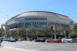
 | Bill Graham Civic Auditorium The Bill Graham Civic Auditorium is a multi-purpose arena in San Francisco, California, named after promoter Bill Graham. The arena holds 8,500 people. |
 | Merola Opera Program Merola Opera Program is a San Francisco based training program for opera singers, coaches, and stage directors. Merola opera program is based in San Francisco. |
Visit San Francisco plaques
 0
0
plaques
here San Francisco has 0 physical plaques in tourist plaque schemes for you to explore via Walkfo San Francisco plaques audio map when visiting. Plaques like National Heritage’s “Blue Plaques” provide visual geo-markers to highlight points-of-interest at the places where they happened – and Walkfo’s AI has researched additional, deeper content when you visit San Francisco using the app. Experience the history of a location when Walkfo local tourist guide app triggers audio close to each San Francisco plaque. Currently No Physical Plaques.


 Trying to encourage visitors to San Francisco?