Welcome to Visit Salisbury Places
The Walkfo guide to things to do & explore in Salisbury
 Visit Salisbury places using Walkfo for free guided tours of the best Salisbury places to visit. A unique way to experience Salisbury’s places, Walkfo allows you to explore Salisbury as you would a museum or art gallery with audio guides.
Visiting Salisbury Walkfo Preview
Salisbury is a cathedral city in Wiltshire, England, with a population of 40,302. The city is at the confluence of the rivers Avon, Nadder and Bourne. Stonehenge, a UNESCO World Heritage Site, is 8 miles (13 km) northwest of the city. When you visit Salisbury, Walkfo brings Salisbury places to life as you travel by foot, bike, bus or car with a mobile phone & headphones.
Salisbury Places Overview: History, Culture & Facts about Salisbury
Visit Salisbury – Walkfo’s stats for the places to visit
With 64 audio plaques & Salisbury places for you to explore in the Salisbury area, Walkfo is the world’s largest heritage & history digital plaque provider. The AI continually learns & refines facts about the best Salisbury places to visit from travel & tourism authorities (like Wikipedia), converting history into an interactive audio experience.
Salisbury history
Old Sarum

The hilltop at Old Sarum lies near the Neolithic sites of Stonehenge and Avebury. It commanded a salient between the River Bourne and the Hampshire Avon, near a crossroads of several early trade routes. During the Iron Age, sometime between 600 and 300 BC, a hillfort (oppidum) was constructed around it. The Romans may have occupied the site or left it in the hands of an allied tribe.
New Sarum

Bishop of Salisbury Hubert Walter was instrumental in the negotiations with Saladin during the Third Crusade, but he spent little time in his diocese prior to his elevation to archbishop of Canterbury. The brothers Herbert and Richard Poore succeeded him and began planning the relocation of the cathedral into the valley almost immediately. Their plans were approved by King Richard I but repeatedly delayed: Herbert was first forced into exile in Normandy in the 1190s by the hostility of his archbishop Walter and then again to Scotland in the 1210s owing to royal hostility following the papal interdiction against King John. The secular authorities were particularly incensed, according to tradition, owing to some of the clerics debauching the castellan’s female relations. In the end, the clerics were refused permission to reenter the city walls following their rogations and processions. This caused Peter of Blois to describe the church as “a captive within the walls of the citadel like the ark of God in the profane house of Baal”. He advocated Let us descend into the plain! There are rich fields and fertile valleys abounding in the fruits of the earth and watered by the living stream. There is a seat for the Virgin Patroness of our church to which the world cannot produce a parallel. Herbert Poore’s successor and brother Richard Poore eventually moved the cathedral to a new town on his estate at Veteres Sarisberias (“Old Salisburies”) in 1220. The site was at “Myrifield” (“Merryfield”), a meadow near the confluence of the River Nadder and the Hampshire Avon. It was first known as “New Sarum” or New Saresbyri. The town was laid out on a grid. Work on the new cathedral building, the present Salisbury Cathedral, began in 1221. The site was supposedly established by shooting an arrow from Old Sarum, although this is certainly a legend: the distance is over 3 km (1.9 mi). The legend is sometimes amended to claim that the arrow struck a white deer, which continued to run and died on the spot where the cathedral now rests. The structure was built upon wooden faggots on a gravel bed with unusually shallow foundations of 18 inches (46 cm) and the main body was completed in only 38 years. The 123 m or 404 ft tall spire, the tallest in the UK, was built later. With royal approval, many of the stones for the new cathedral were taken from the old one; others came from Chilmark. They were probably transported by ox-cart, owing to the obstruction to boats on the River Nadder caused by its many weirs and watermills. The cathedral is considered a masterpiece of Early English architecture. The spire’s large clock was installed in 1386, and is one of the oldest surviving mechanical clocks in the world. The Cathedral also contains the best-preserved of the four surviving copies of Magna Carta. New Sarum was made a city by a charter from King Henry III in 1227 and, by the 14th century, was the largest settlement in Wiltshire. The city wall surrounds the Close and was built in the 14th century, again with stones removed from the former cathedral at Old Sarum. The wall now has five gates: the High Street Gate, St Ann’s Gate, the Queen’s Gate, and St Nicholas’s Gate were original, while a fifth was constructed in the 19th century to allow access to Bishop Wordsworth’s School, in the Cathedral Close. During his time in the city, the composer Handel stayed in a room above St Ann’s gate. The original site of the city at Old Sarum, meanwhile, fell into disuse. It continued as a rotten borough: at the time of its abolition during the reforms of 1832, its Member of Parliament (MP) represented three households. In May 1289, there was uncertainty about the future of Margaret, Maid of Norway, and her father sent ambassadors to Edward I. Edward met Robert the Bruce and others at Salisbury in October 1289, which resulted in the Treaty of Salisbury, under which Margaret would be sent to Scotland before 1 November 1290 and any agreement on her future marriage would be delayed until she was in Scotland. The Parliament of England met at New Sarum in the years 1324, 1328, and 1384. In 1450, a number of riots broke out in Salisbury at roughly the same time as Jack Cade led a famous rebellion through London. The riots occurred for related reasons, although the declining fortunes of Salisbury’s cloth trade may also have been influential. The violence peaked with the murder of the bishop, William Ayscough, who been involved with the government. In 1483, a large-scale rebellion against Richard III broke out, led by his own ‘kingmaker’, Henry Stafford, 2nd Duke of Buckingham. After the revolt collapsed, Buckingham was executed at Salisbury, near the Bull’s Head Inn. In 1664, an act for making the River Avon navigable from Christchurch to the city of New Sarum was passed and the work completed, only for the project to be ruined shortly thereafter by a major flood. Soon after, during the Great Plague of London, Charles II held court in Salisbury’s cathedral close. Salisbury was the site chosen to assemble James II’s forces to resist the Glorious Revolution. He arrived to lead his approximately 19 000 men on 19 November 1688. His troops were not keen to fight Mary or her husband William, and the loyalty of many of James’s commanders was in doubt. The first blood was shed at the Wincanton Skirmish, in Somerset. In Salisbury, James heard that some of his officers had deserted, such as Edward Hyde, and he broke out in a nosebleed, which he took as an omen that he should retreat. His commander in chief, the Earl of Feversham, advised retreat on 23 November, and the next day John Churchill defected to William. On 26 November, James’s own daughter, Princess Anne, did the same, and James returned to London the same day, never again to be at the head of a serious military force in England.
20th and 21st centuries: Salisbury

Salisbury was the major centre of production, supplemented by Trowbridge and Reading. Several factories were set up in the centre of Salisbury and manned by predominantly young women. Supporting the factories were many workers producing small components in home-based workshops and garden sheds. Sub-assemblies were built in the city centre factories and then transported to High Post airfield.
Salisbury culture & places
Salisbury was an important centre for music in the 18th century. The grammarian James Harris directed concerts at the Assembly Rooms for almost 50 years up to his death in 1780. John Constable made a number of celebrated landscape paintings featuring the cathedral’s spire.
Salisbury Museum
Salisbury Museum is housed in the King’s House, opposite the west front of the cathedral. The permanent Stonehenge exhibition gallery has interactive displays about the archaeology of south Wiltshire. The Pitt Rivers display holds a collection from General Augustus Pitt Rivers.
Salisbury geography / climate

The geology of the area, as with much of South Wiltshire and Hampshire, is largely chalk. The rivers which flow through the city have been redirected, and along with landscaping, have been used to feed into public gardens. The Town Path, a walkway that links Harnham with the rest of the city, is at times impassable.
Areas and suburbs
The boundaries of these areas are for the most part unofficial and not fixed. All of these suburbs are within Salisbury’s ONS Urban Area, which had a population of 44,748 in 2011. Two parishes are part of the urban area but outside Salisbury parish.
Why visit Salisbury with Walkfo Travel Guide App?
 You can visit Salisbury places with Walkfo Salisbury to hear history at Salisbury’s places whilst walking around using the free digital tour app. Walkfo Salisbury has 64 places to visit in our interactive Salisbury map, with amazing history, culture & travel facts you can explore the same way you would at a museum or art gallery with information audio headset. With Walkfo, you can travel by foot, bike or bus throughout Salisbury, being in the moment, without digital distraction or limits to a specific walking route. Our historic audio walks, National Trust interactive audio experiences, digital tour guides for English Heritage locations are available at Salisbury places, with a AI tour guide to help you get the best from a visit to Salisbury & the surrounding areas.
“Curated content for millions of locations across the UK, with 64 audio facts unique to Salisbury places in an interactive Salisbury map you can explore.”
Walkfo: Visit Salisbury Places Map
64 tourist, history, culture & geography spots
Salisbury historic spots | Salisbury tourist destinations | Salisbury plaques | Salisbury geographic features |
| Walkfo Salisbury tourism map key: places to see & visit like National Trust sites, Blue Plaques, English Heritage locations & top tourist destinations in Salisbury | |||
Best Salisbury places to visit
Salisbury has places to explore by foot, bike or bus. Below are a selection of the varied Salisbury’s destinations you can visit with additional content available at the Walkfo Salisbury’s information audio spots:
 | St Paul’s Church, Salisbury St Paul’s Church, Salisbury, England, is located on the north-west side of the city . It is a short walk from the city centre and Salisbury train station . |
 | St Francis’s Church, Salisbury St Francis Church, Salisbury is an evangelical, charismatic Church of England parish church . The church stands in the north of Salisbury, Wiltshire, on the A345 Castle Road . |
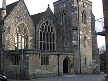
 | Old Sarum Cathedral Only its foundations remain, in the northwest quadrant of the circular outer bailey of the site, which is located near modern Salisbury, Wiltshire . The cathedral was the seat of the bishops of Salisbury during the early Norman period . |
 | St Lawrence, Stratford-sub-Castle St Lawrence’s Church at Stratford-sub-Castle is a Grade I listed Church of England parish church. It stands close to the abandoned settlement of Old Sarum and about 2 miles (3.2 km) north of Salisbury Cathedral. |
 | Old Sarum Airfield Old Sarum Airfield is a grass strip airfield 2 nautical miles (4 km; 2 mi) north-north-east of Salisbury, Wiltshire. The adjacent areas are a mix of vacant land, residential and industrial sites. The site has three Grade II* listed hangars and a Grade II listed former workshop. |
Visit Salisbury plaques
 47
47
plaques
here Salisbury has 47 physical plaques in tourist plaque schemes for you to explore via Walkfo Salisbury plaques audio map when visiting. Plaques like National Heritage’s “Blue Plaques” provide visual geo-markers to highlight points-of-interest at the places where they happened – and Walkfo’s AI has researched additional, deeper content when you visit Salisbury using the app. Experience the history of a location when Walkfo local tourist guide app triggers audio close to each Salisbury plaque. Explore Plaques & History has a complete list of Hartlepool’s plaques & Hartlepool history plaque map.


 Trying to encourage visitors to Salisbury?