Welcome to Visit Salford Places
The Walkfo guide to things to do & explore in Salford
 Visit Salford places using Walkfo for free guided tours of the best Salford places to visit. A unique way to experience Salford’s places, Walkfo allows you to explore Salford as you would a museum or art gallery with audio guides.
Visiting Salford Walkfo Preview
Salford was granted a charter by Ranulf de Blondeville, 6th Earl of Chester, in about 1230 . It was granted city status in 1926 . The wider Metropolitan Borough of the City was established in 1974 with responsibility for a significantly larger region . It became the headquarters of CBBC and BBC Sport . When you visit Salford, Walkfo brings Salford places to life as you travel by foot, bike, bus or car with a mobile phone & headphones.
Salford Places Overview: History, Culture & Facts about Salford
Visit Salford – Walkfo’s stats for the places to visit
With 369 audio plaques & Salford places for you to explore in the Salford area, Walkfo is the world’s largest heritage & history digital plaque provider. The AI continually learns & refines facts about the best Salford places to visit from travel & tourism authorities (like Wikipedia), converting history into an interactive audio experience.
Salford history
Toponymy
The name of Salford derives from the Old English word Sealhford, meaning a ford by the willow trees . It referred to the willows (Latin: salix) or sallows that grew alongside the banks of the River Irwell . Willow trees are still found in Lower Broughton .
Early history

The earliest known evidence of human activity in what is now Salford is provided by the Neolithic flint arrow-heads and workings discovered on Kersal Moor and the River Irwell, suggesting that the area was inhabited 7–10,000 years ago. The raw material for such tools was scarce and unsuitable for working, and as a result they are not of the quality found elsewhere. Other finds include a neolithic axe-hammer found near Mode Wheel, during the excavation of the Manchester Ship Canal in 1890, and a Bronze Age cremation urn during the construction of a road on the Broughton Hall estate in 1873. The Brigantes were the major Celtic tribe in what is now Northern England. With a stronghold at the sandstone outcrop on which Manchester Cathedral now stands, opposite Salford’s original centre, their territory extended across the fertile lowland by the River Irwell that is now Salford and Stretford. Following the Roman conquest of Britain, General Agricola ordered the construction of a Roman fort named Mamucium (Manchester) to protect the routes to Deva Victrix (Chester) and Eboracum (York) from the Brigantes. Salford was founded when the fort was completed in AD 79, and for over 300 years the Pax Romana brought peace to the area. Both the main Roman road to the north, from Mamucium to Ribchester, and a second road to the west, ran through what is now Salford, but few Roman artefacts have been found in the area. The withdrawal of the Romans in AD 410 left the inhabitants at the mercy of the Saxons. The Danes later conquered the area and absorbed what was left of the Brigantes. Angles settled in the region during the Early Middle Ages and gave the locality the name Sealhford, meaning “ford by the willows”. According to the Anglo-Saxon Chronicle, Sealhford was part of the Kingdom of Northumbria until it was conquered in 923 by Edward the Elder. Following the emergence of the united Kingdom of England, Salford became a caput or central manor within a broad rural area in part held by the Kings of England, including Edward the Confessor. The area between the rivers Mersey and Ribble was divided into six smaller districts, referred to as “wapentakes”, or hundreds. The south east district became known as the Hundred of Salford, a division of land administered from Salford for military and judicial purposes. It contained nine large parishes, smaller parts of two others, and the township of Aspull in the parish of Wigan. After the defeat of Harold II during the Norman conquest of England, William I granted the Hundred of Salford to Roger the Poitevin, and in the Domesday Book of 1086 the Hundred of Salford was recorded as covering an area of 350 square miles (906 km) with a population of 35,000. Poitevin created the subordinate Manor of Manchester out of the hundred, which has since in local government been separate from Salford. Poitevin forfeited the manor in 1102 when he was defeated in a failed rebellion attempt against Henry I. In around 1115, for their support during the rebellion, Henry I placed the Hundred of Salford under the control of the Earldom of Lancaster, and it is from this exchange that the Hundred of Salford became a royal manor. The Lord of the Manor was either the English monarch, or a feudal land owner who administered the manor for the king. During the reign of Henry II the Royal Manor of Salford passed to Ranulf de Gernon, 4th Earl of Chester. Salford began to emerge as a small town early in the 13th century. In 1228, Henry III granted the caput of Salford the right to hold a market and an annual fair. The fairs were important to the town; a 17th-century order forced each burgess – a freeman of the borough – to attend, but the fairs were abolished during the 19th century. The Earls of Chester aided the development of the caput, and in 1230 Ranulf de Blondeville, 6th Earl of Chester made Salford a burgage, or free borough. The charter gave its burgesses certain commercial rights, privileges and advantages over traders living outside Salford; one of the 26 clauses of the charter stated that no one could work in the Hundred of Salford unless they also lived in the borough. Salford’s status as a burgage encouraged an influx of distinguished families, and by the Late Middle Ages Salford was “rich in its manor houses”, with over 30 within a 5-mile (8 km) radius of Ordsall. These included Ordsall Hall (owned by the Radclyffe family) and Broughton Hall, owned by the Earls of Derby. During the Civil War of 1640–49, Salford supported the Royalist cause, in contrast to Manchester just across the Irwell which declared in favour of the Parliamentarians. Royalist forces mounted a siege of Manchester across what is now the site of Victoria Bridge, which although short-lived, “did little to improve relations between the two towns”. A century later, in 1745, Salford was staunchly in support of Bonnie Prince Charlie, in his attempt to seize the Throne of England. He entered the town at the head of his army and was blessed by the Reverend John Clayton before leaving “in high spirits” to march on London; he returned to Salford in defeat just nine days later.
Industrial Revolution

Salford has a history of textile processing that pre-dates the Industrial Revolution, and as an old town had been developing for about 700 years. Before the introduction of cotton there was a considerable trade in woollen goods and fustians. Other cottage industries prevalent at this time included clogging, cobbling, weaving and brewing. The changes to textile manufacture during the Industrial Revolution had a profound effect on both on population and urbanisation, as well as the socioeconomic and cultural conditions of Salford. The well-established textile processing and trading infrastructure, and the ready supply of water from the River Irwell and its tributaries, attracted entrepreneurs who built cotton mills along the banks of the river in Pendleton and Ordsall. Although Salford followed a similar pattern of industrial development to Manchester, most businesses preferred to build their premises on the Manchester side of the Irwell, and consequently Salford did not develop as a commercial centre in the same way as its neighbour. Many of these earlier mills had been based on Arkwright-type designs. These relied on strong falls of water, but Salford is on a meander of the Irwell with only a slight gradient and thus mills tended to be built upstream, at Kersal and Pendleton. However, with the introduction of the steam engine in the late 18th century, merchants began to construct mills closer to the centres of Salford and Manchester, where supplies of labour and coal were more readily available (the first steam-powered mill was built in Manchester in 1780). One of the first factories to be built was Philip’s and Lee’s Twist Mill in Salford, completed in 1801, the second iron-framed multi-story building to be erected in Britain. The large Salford Engine Twist Company mill was built to the west of Salford, between Chapel Street and the Irwell, and in 1806 was the first large cotton mill to use gas lighting. Many engineering companies were established in this area, including Samuel Ellis and Company at the Irwell Foundry. However, it was outnumbered by the numerous smaller factories and mills throughout the area, including Nathan Gough’s steam-driven mule spinning mill, near Oldfield Road, where a serious accident occurred on 13 October 1824 (see illustration). Canal building provided a further stimulus for Salford’s industrial development. The opening of the Bridgewater Canal in 1761 improved the transport of fuel and raw materials, reducing the price of coal by about 50%. The later Manchester, Bolton & Bury Canal (which terminated at Salford) brought more cheap coal from pits at Pendleton, Agecroft Colliery and beyond. By 1818 Manchester, Salford and Eccles had about 80 mills, but it was the completion of the Manchester Ship Canal in 1894 which triggered Salford’s development as a major inland port. Salford Docks, a major dockland on the Ship Canal 35 miles (56 km) east of the Irish Sea, brought employment to over 3,000 labourers. By 1914 the Port of Manchester, most of whose docks were in Salford, had become one of the largest port authorities in the world, handling 5% of the UK’s imports and 4.4% of its exports. Commodities handled included cotton, grain, wool, textile machinery and steam locomotives. For centuries, textiles and related trades were the main source of employment in the town. Bleaching was a widely distributed finishing trade in Salford, carried over from the earlier woollen industry. In the 18th century, before the introduction of chemical bleaching, bleaching fields were commonplace, some very close to the town. In 1773 there were 25 bleachers around Salford, most to the west of the township. Printing was another source of trade; the earliest recorded in the region was a calique printer in the Manchester Parish Register of 1763. These industries became more important as Salford faced increasing competition from the nearby towns of Bolton and Oldham. As its cotton spinning industries faltered its economy turned increasingly to other textiles and to the finishing trades, including rexine and silk dyeing, and fulling and bleaching, at a string of works in Salford. Both Karl Marx and Friedrich Engels spent time in Salford, studying the plight of the British working class. In The Condition of the Working Class in England in 1844, Engels described Salford as “really one large working-class quarter … [a] very unhealthy, dirty and dilapidated district which, while other industries were almost always textile related is situated opposite the ‘Old Church’ of Manchester”. Salford developed several civic institutions; in 1806, Chapel Street became the first street in the world to be lit by gas (supplied by Phillips and Lee’s cotton mill). In 1850, under the terms of the Museums Act 1845, the municipal borough council established the Royal Museum and Public Library, said to have been the first unconditional free public library in England, preceding the Public Libraries Act 1850. The effect on Salford of the Industrial Revolution has been described as “phenomenal”. The area expanded from a small market town into a major industrial metropolis; factories replaced cottage industries, and the population rose from 12,000 in 1812 to 70,244 within 30 years. By the end of the 19th century it had increased to 220,000. Large-scale building of low quality Victorian terraced housing did not stop overcrowding, which itself led to chronic social deprivation. The density of housing was as high as 80 homes per acre. Private roads were built for the use of the middle classes moving to the outskirts of Salford. The entrances to such roads, which included Elleray Road in Irlams o’ th’ Height, were often gated, and patrolled.
Post-industrial decline

The population of Salford decreased by 29% between 1921 and 1939, far greater than the rate of decline within the whole of North West England . A survey in 1931 concluded that parts of the city contained some of the worst slums in the country . Large areas of city were redeveloped in the 1960s and 1970s, with Victorian era terraced housing estates that inspired painter L. S. Lowry giving way to concrete tower blocks .
Regeneration

Salford has suffered from high levels of unemployment, housing, and social problems since around the 1960s . Many of the high-rise housing blocks were demolished during the 1990s, a sign that the great social engineering schemes (from that period) had failed”. However, there are regeneration schemes to reverse its fortunes .
Salford culture & places

Salford Museum and Art Gallery opened in November 1850 as the Royal Museum and Public Library. It was built on the site of Lark Hill estate and Mansion, which was purchased by public subscription. The folk song “Dirty Old Town”, written by native Ewan MacColl, is the origin of the town’s nickname. The videos for the Timbaland song “The Way I Are”, and the Justin Timberlake song “Lovestoned” were filmed in the town.
Salford landmarks
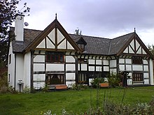
Ordsall Hall, a Tudor mansion and former stately home, dates back over 750 years. Salford Cathedral is a decorated neo-Gothic Roman Catholic church built between 1844 and 1848. The Smiths’ Lads’ Club is a listed building and gained international fame in 1986 when the Smiths posed in front of it for the inside cover of The Queen Is Dead.
Salford geography / climate

At 53°28′59″N 2°17′35″W / 53.48306°N 2.29306°W / 53.483°, -2.2931°, Salford is 205 miles (330 km) northwest of central London. The River Irwell, sourced at Cliviger in Lancashire, flows from the north and for a distance forms the statutory boundary between Salfords and Manchester. The territory is contiguous with other towns on all sides and as defined by the Office for National Statistics forms the sixth-largest settlement in the Greater Manchester Urban Area.
Why visit Salford with Walkfo Travel Guide App?
 You can visit Salford places with Walkfo Salford to hear history at Salford’s places whilst walking around using the free digital tour app. Walkfo Salford has 369 places to visit in our interactive Salford map, with amazing history, culture & travel facts you can explore the same way you would at a museum or art gallery with information audio headset. With Walkfo, you can travel by foot, bike or bus throughout Salford, being in the moment, without digital distraction or limits to a specific walking route. Our historic audio walks, National Trust interactive audio experiences, digital tour guides for English Heritage locations are available at Salford places, with a AI tour guide to help you get the best from a visit to Salford & the surrounding areas.
“Curated content for millions of locations across the UK, with 369 audio facts unique to Salford places in an interactive Salford map you can explore.”
Walkfo: Visit Salford Places Map
369 tourist, history, culture & geography spots
Salford historic spots | Salford tourist destinations | Salford plaques | Salford geographic features |
| Walkfo Salford tourism map key: places to see & visit like National Trust sites, Blue Plaques, English Heritage locations & top tourist destinations in Salford | |||
Best Salford places to visit
Salford has places to explore by foot, bike or bus. Below are a selection of the varied Salford’s destinations you can visit with additional content available at the Walkfo Salford’s information audio spots:

St Ann’s, Stretford
St Ann’s Church, Stretford is a Grade II listed Roman Catholic church . It was constructed between 1862 and 1863, on the east side of the A56 Chester Road . The parish functions under the jurisdiction of the Roman Catholic Diocese of Salford .

Circle Square Manchester
Circle Square is a 2.4 million sq ft development of Manchester City Centre . It is a joint venture between Vita Group and Bruntwood SciTech . The development is estimated to have cost £750 million .

Dancehouse
The Dancehouse is a dance centre at 10 Oxford Road, Manchester, England . It is located in the centre of Manchester’s dance centre .

Sackville Gardens
The land was purchased by Manchester Corporation in 1900 and laid out with walks, lawns and flower beds . Known as Whitworth Gardens, it was planned to complement the Municipal College of Technology’s Sackville Street Building .

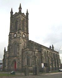
Church of the Ascension, Lower Broughton
The Church of the Ascension is a Grade II listed Anglican church in Lower Broughton, Salford, England. In February 2017 a fire destroyed the roof and interior of the building.

HM Prison Manchester
HM Prison Manchester is a high-security men’s prison in Manchester, England, operated by Her Majesty’s Prison Service. It is known for its prominent ventilation tower and imposing design. It was designed by Alfred Waterhouse and opened in 1868 alongside the demolished Manchester Assize Courts.

Municipal Borough of Stretford
Stretford was, from 1868 to 1974, a local government district coterminate with the town of Stretford, Lancashire.
![]()
Real Radio XS
Real Radio XS was a radio station brand operated by Real and Smooth Ltd (formerly GMG Radio) based in Salford, Greater Manchester, broadcasting a variety of peak-time news, rock music and talk output. The Manchester-based version of the service was broadcast to Greater Manchester on FM, and to a number of areas on DAB.

Irwell Riverside (ward)
Irwell Riverside (ward) is an electoral ward of Salford, England. The ward is bounded by meanders of the River Irwell and includes the main university campus. It is represented in Westminster by Rebecca Long-Bailey MP for Salfords and Eccles.
St Thomas’ Church, Pendleton
St Thomas’ Church is on Broad Street, Pendleton, Salford, Greater Manchester. It was a Commissioners’ church, having received a grant towards its construction from the Church Building Commission. It is designated by English Heritage as a Grade II listed building.
Visit Salford plaques
 171
171
plaques
here Salford has 171 physical plaques in tourist plaque schemes for you to explore via Walkfo Salford plaques audio map when visiting. Plaques like National Heritage’s “Blue Plaques” provide visual geo-markers to highlight points-of-interest at the places where they happened – and Walkfo’s AI has researched additional, deeper content when you visit Salford using the app. Experience the history of a location when Walkfo local tourist guide app triggers audio close to each Salford plaque. Explore Plaques & History has a complete list of Hartlepool’s plaques & Hartlepool history plaque map.


 Trying to encourage visitors to Salford?