Welcome to Visit Salendine Nook Places
The Walkfo guide to things to do & explore in Salendine Nook
 Visit Salendine Nook places using Walkfo for free guided tours of the best Salendine Nook places to visit. A unique way to experience Salendine Nook’s places, Walkfo allows you to explore Salendine Nook as you would a museum or art gallery with audio guides.
Visiting Salendine Nook Walkfo Preview
Salendine Nook is 2 miles (3 km) to the north-west of central Huddersfield. It lies on a tributary to the textile industries’ Packhorse road across the Pennines. Architecturally, the area features traditional weavers’ cottages exhibiting vestiges of workshop entrances. When you visit Salendine Nook, Walkfo brings Salendine Nook places to life as you travel by foot, bike, bus or car with a mobile phone & headphones.
Salendine Nook Places Overview: History, Culture & Facts about Salendine Nook
Visit Salendine Nook – Walkfo’s stats for the places to visit
With 62 audio plaques & Salendine Nook places for you to explore in the Salendine Nook area, Walkfo is the world’s largest heritage & history digital plaque provider. The AI continually learns & refines facts about the best Salendine Nook places to visit from travel & tourism authorities (like Wikipedia), converting history into an interactive audio experience.
Salendine Nook history
There is no record of Salendine Nook in the 1086 Domesday Book. Lindley (Lilleia) and Quarmby (Cornebi) are both mentioned, albeit as ‘waste’ The Mortons, who became a major influence in the area, are believed to have settled in the 16th century. Edmond de Morton and “a numerous Scotch family” fled from religious persecution in Scotland to find a home south of the border.
Pottery
The Mortons were potters, and the area attracted them because it was the source of a very pure clay worked for the manufacture of earthenware pottery. The clay was found in the seat-earths in a geological formation known as the Lower Coal Measures at Lockwood Scar, Lindley Moor and Salendine Nook.
Salendine Nook Baptist Chapel

Michael Morton registered his barn in October 1689 as a meeting house for Protestant dissenters and established the building as a religious site. The Toleration Act of the same year allowed for a degree of religious freedom which had not existed before. A meeting house was opened on the land of Joseph Morton between 1743 and was replaced by a larger one in 1803. The current Baptist Chapel was built in 1843.
Why visit Salendine Nook with Walkfo Travel Guide App?
 You can visit Salendine Nook places with Walkfo Salendine Nook to hear history at Salendine Nook’s places whilst walking around using the free digital tour app. Walkfo Salendine Nook has 62 places to visit in our interactive Salendine Nook map, with amazing history, culture & travel facts you can explore the same way you would at a museum or art gallery with information audio headset. With Walkfo, you can travel by foot, bike or bus throughout Salendine Nook, being in the moment, without digital distraction or limits to a specific walking route. Our historic audio walks, National Trust interactive audio experiences, digital tour guides for English Heritage locations are available at Salendine Nook places, with a AI tour guide to help you get the best from a visit to Salendine Nook & the surrounding areas.
“Curated content for millions of locations across the UK, with 62 audio facts unique to Salendine Nook places in an interactive Salendine Nook map you can explore.”
Walkfo: Visit Salendine Nook Places Map
62 tourist, history, culture & geography spots
Salendine Nook historic spots | Salendine Nook tourist destinations | Salendine Nook plaques | Salendine Nook geographic features |
| Walkfo Salendine Nook tourism map key: places to see & visit like National Trust sites, Blue Plaques, English Heritage locations & top tourist destinations in Salendine Nook | |||
Best Salendine Nook places to visit
Salendine Nook has places to explore by foot, bike or bus. Below are a selection of the varied Salendine Nook’s destinations you can visit with additional content available at the Walkfo Salendine Nook’s information audio spots:

Lindley, Huddersfield
Lindley is a suburb of Huddersfield, within the metropolitan borough of Kirklees in West Yorkshire, England. It is approximately 2 miles (3 km) northwest from the town centre. It was officially opened only in 1967, by Prime Minister Harold Wilson.
Birkby, Huddersfield
Birkby is a large multi-cultural suburb close to the town centre in Huddersfield, in the Kirklees borough of West Yorkshire. It has a population of 6,700 and sits in the Grimescar Valley, a greenbelt area of the city. It contains Norman Park, a small park with a play area and a war memorial, which commemorates those who died in WWI.
Sowood, West Yorkshire
Sowood is 2.3 miles (3.7 km) south-west of Elland, 4.1 miles (6.6 km) north of Huddersfield. The village falls within the Greetland and Stainland ward of Calderdale Council.
Fartown, Huddersfield
Fartown is a district of Huddersfield, West Yorkshire, England that starts 0.6 miles (1 km) north of the town centre. The district area stretches from the top of Woodhouse Hill to the Halifax Old Road with a population of 4,735 according to the 2001 Census. The area has a multi-ethnic population with a significant percentage hailing from South Asian and West Indian backgrounds.

Rugby League Heritage Centre
The Rugby League Heritage Centre was formerly located in the basement of the George Hotel, Huddersfield, West Yorkshire. It was the brainchild of Sky Sports presenter and former Great Britain international Mike Stephenson.

St Patrick’s Church, Huddersfield
St Patrick’s Church is a Roman Catholic church in Huddersfield, West Yorkshire. Built in 1832 for use as a parish church, it was designed by Joseph Kaye, an architect from Bradford. It is situated on the junction between New North Road and Castlegate in the centre of the town.
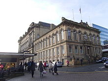
Huddersfield Town Hall
Huddersfield Town Hall is a municipal facility in West Yorkshire, West Yorkshire. It is a Grade II listed building. The town hall is located in the city centre.

Colne Valley Museum
The Colne Valley Museum is located in Golcar, Huddersfield, West Yorkshire. It consists of four converted 19th century weavers’ cottages. The museum provides an insight into what life was like for a weaver in the early 1850s.

Slack Roman Fort
Slack Roman Fort was a castellum near Outlane, to the west of Huddersfield in West Yorkshire, England. It lay alongside the Pennine section of the Roman road from Deva Victrix (Chester) to Eboracum (York) The fort may have been the Cambodunum mentioned as a station on this route in the Antonine Itinerary.
Visit Salendine Nook plaques
 1
1
plaques
here Salendine Nook has 1 physical plaques in tourist plaque schemes for you to explore via Walkfo Salendine Nook plaques audio map when visiting. Plaques like National Heritage’s “Blue Plaques” provide visual geo-markers to highlight points-of-interest at the places where they happened – and Walkfo’s AI has researched additional, deeper content when you visit Salendine Nook using the app. Experience the history of a location when Walkfo local tourist guide app triggers audio close to each Salendine Nook plaque. Explore Plaques & History has a complete list of Hartlepool’s plaques & Hartlepool history plaque map.


 Trying to encourage visitors to Salendine Nook?