Welcome to Visit Ryton, Tyne and Wear Places
The Walkfo guide to things to do & explore in Ryton, Tyne and Wear
 Visit Ryton, Tyne and Wear places using Walkfo for free guided tours of the best Ryton, Tyne and Wear places to visit. A unique way to experience Ryton, Tyne and Wear’s places, Walkfo allows you to explore Ryton, Tyne and Wear as you would a museum or art gallery with audio guides.
Visiting Ryton, Tyne and Wear Walkfo Preview
Ryton is 5.8 miles (9.3 km) west of Newcastle upon Tyne. Historically in County Durham, it was incorporated into the Metropolitan Borough of Gateshead in 1974. In 2011 the population of the Ryton, Crookhill and Stella ward was 8,146. When you visit Ryton, Tyne and Wear, Walkfo brings Ryton, Tyne and Wear places to life as you travel by foot, bike, bus or car with a mobile phone & headphones.
Ryton, Tyne and Wear Places Overview: History, Culture & Facts about Ryton, Tyne and Wear
Visit Ryton, Tyne and Wear – Walkfo’s stats for the places to visit
With 39 audio plaques & Ryton, Tyne and Wear places for you to explore in the Ryton, Tyne and Wear area, Walkfo is the world’s largest heritage & history digital plaque provider. The AI continually learns & refines facts about the best Ryton, Tyne and Wear places to visit from travel & tourism authorities (like Wikipedia), converting history into an interactive audio experience.
Ryton, Tyne and Wear history
Ryton’s economy was built upon agriculture and coal mining. The village is now a commuter village for people working in the more urban areas of Tyneside. The most notable mansion in the village is The Grove, formerly known as Ryton Grove.
Ryton, Tyne and Wear geography / climate
Ryton Willows Local Nature Reserve is located on the banks of the Tyne. It consists of 43 hectares of grassland, ponds, woodland and locally rare species of flora and fauna. The neighbouring village of Crawcrook is a nexus of coal mining nostalgia also. Other areas of countryside include nearby Stargate pond and Addison woods.
Why visit Ryton, Tyne and Wear with Walkfo Travel Guide App?
 You can visit Ryton, Tyne and Wear places with Walkfo Ryton, Tyne and Wear to hear history at Ryton, Tyne and Wear’s places whilst walking around using the free digital tour app. Walkfo Ryton, Tyne and Wear has 39 places to visit in our interactive Ryton, Tyne and Wear map, with amazing history, culture & travel facts you can explore the same way you would at a museum or art gallery with information audio headset. With Walkfo, you can travel by foot, bike or bus throughout Ryton, Tyne and Wear, being in the moment, without digital distraction or limits to a specific walking route. Our historic audio walks, National Trust interactive audio experiences, digital tour guides for English Heritage locations are available at Ryton, Tyne and Wear places, with a AI tour guide to help you get the best from a visit to Ryton, Tyne and Wear & the surrounding areas.
“Curated content for millions of locations across the UK, with 39 audio facts unique to Ryton, Tyne and Wear places in an interactive Ryton, Tyne and Wear map you can explore.”
Walkfo: Visit Ryton, Tyne and Wear Places Map
39 tourist, history, culture & geography spots
Ryton, Tyne and Wear historic spots | Ryton, Tyne and Wear tourist destinations | Ryton, Tyne and Wear plaques | Ryton, Tyne and Wear geographic features |
| Walkfo Ryton, Tyne and Wear tourism map key: places to see & visit like National Trust sites, Blue Plaques, English Heritage locations & top tourist destinations in Ryton, Tyne and Wear | |||
Best Ryton, Tyne and Wear places to visit
Ryton, Tyne and Wear has places to explore by foot, bike or bus. Below are a selection of the varied Ryton, Tyne and Wear’s destinations you can visit with additional content available at the Walkfo Ryton, Tyne and Wear’s information audio spots:
 | Tyne Rowing Club Tyne Amateur Rowing Club (TARC) is the longest established rowing club on the River Tyne in Newcastle upon Tyne, UK. |
 | Milecastle 9 Milecastle 9 (Chapel House) was a milecastle of the Roman Hadrian’s Wall. Its remains exist partially as a low platform, and are located in West Denton (to the west of Newcastle upon Tyne) |
| Milecastle 10 Milecastle 10 (Walbottle Dene) was a milecastle of the Roman Hadrian’s Wall. It is located near to the modern village of Throckley in Tyne and Wear, northern England. It has been excavated several times and its walls located, though the remains have been damaged by ploughing. |
 | Lemington Glass Works Lemington Glass Works was the site of glass production in Lemington, Newcastle upon Tyne, England, for over 200 years. All that remains now is its iconic last glass cone, a famous local landmark. |
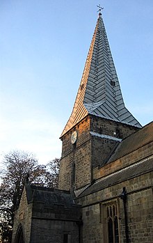 | Holy Cross Church, Ryton Holy Cross Church is a Church of England parish church in Ryton, Tyne and Wear. The church is a Grade I listed building. |
 | Crookhill Crookhill is an area of Ryton in Tyne and Wear, England. The original terraced housing was built mostly as accommodation for NCB workers. |
 | Stella Park Stella Park is a housing estate in Blaydon-on-Tyne, Tyne and Wear, England. It is located on the grounds of a mansion of the same name. |
| Milecastle 11 Milecastle 11 was a milecastle of the Roman Hadrian’s Wall. No remains exist, but the measured position is the middle of the old village of Throckley Bank Top, under the Working Men’s Club. |
| St Paul’s Church, Winlaton St Paul’s Church is a 19th-century church in Winlaton, Tyne and Wear, England, dedicated to St Paul. |
 | Greenside, Tyne and Wear Greenside is a village in the extreme west of the Metropolitan County of Tyne and Wear. Once an independent village in County Durham, it became incorporated into Tyne & Wear in 1974 and then the Metropolitan Borough of Gateshead in 1986. |
Visit Ryton, Tyne and Wear plaques
 3
3
plaques
here Ryton, Tyne and Wear has 3 physical plaques in tourist plaque schemes for you to explore via Walkfo Ryton, Tyne and Wear plaques audio map when visiting. Plaques like National Heritage’s “Blue Plaques” provide visual geo-markers to highlight points-of-interest at the places where they happened – and Walkfo’s AI has researched additional, deeper content when you visit Ryton, Tyne and Wear using the app. Experience the history of a location when Walkfo local tourist guide app triggers audio close to each Ryton, Tyne and Wear plaque. Explore Plaques & History has a complete list of Hartlepool’s plaques & Hartlepool history plaque map.


 Trying to encourage visitors to Ryton, Tyne and Wear?