Welcome to Visit Ruthin Places
The Walkfo guide to things to do & explore in Ruthin
 Visit Ruthin places using Walkfo for free guided tours of the best Ruthin places to visit. A unique way to experience Ruthin’s places, Walkfo allows you to explore Ruthin as you would a museum or art gallery with audio guides.
Visiting Ruthin Walkfo Preview
Ruthin is a market town and community in Denbighshire, Wales, in the south of the Vale of Clwyd. The town, castle and St Peter’s Square lie on a hill, skirted by villages such as Pwllglas and Rhewl. The name comes from the colour of sandstone bedrock from which the castle was built. When you visit Ruthin, Walkfo brings Ruthin places to life as you travel by foot, bike, bus or car with a mobile phone & headphones.
Ruthin Places Overview: History, Culture & Facts about Ruthin
Visit Ruthin – Walkfo’s stats for the places to visit
 With 28 audio plaques & Ruthin places for you to explore in the Ruthin area, Walkfo is the world’s largest heritage & history digital plaque provider. The AI continually learns & refines facts about the best Ruthin places to visit from travel & tourism authorities (like Wikipedia), converting history into an interactive audio experience.
Ruthin history

Ruthin Castle was started in 1277 by Dafydd, the brother of prince Llywelyn ap Gruffudd. He forfeited the castle when he rebelled against King Edward I with his brother; Edward’s queen, Eleanor, was in residence in 1281. The Marcher Lord, Reginald de Grey, Justiciar of Chester, was given the Cantref of Deffrencloyt (Dyffryn Clwyd) and his family ran the area for 226 years. During the English Civil War, the castle survived an eleven-week siege, after which it was demolished by order of Parliament.
Ruthin geography / climate
Ruthin is 8 miles (13 km) south-east of Denbigh, 12 miles (19 km) north of Corwen, 10 miles (16 km) west of Mold and 14 miles (23 km) east of Cerrigydrudion. The nearest major urban centres are Wrexham at 17 miles (27 km), Rhyl at 18 miles (29 km) and Chester at 23 miles (37 km) to the north-east.
Why visit Ruthin with Walkfo Travel Guide App?
 You can visit Ruthin places with Walkfo Ruthin to hear history at Ruthin’s places whilst walking around using the free digital tour app. Walkfo Ruthin has 28 places to visit in our interactive Ruthin map, with amazing history, culture & travel facts you can explore the same way you would at a museum or art gallery with information audio headset. With Walkfo, you can travel by foot, bike or bus throughout Ruthin, being in the moment, without digital distraction or limits to a specific walking route. Our historic audio walks, National Trust interactive audio experiences, digital tour guides for English Heritage locations are available at Ruthin places, with a AI tour guide to help you get the best from a visit to Ruthin & the surrounding areas.
“Curated content for millions of locations across the UK, with 28 audio facts unique to Ruthin places in an interactive Ruthin map you can explore.”
Walkfo: Visit Ruthin Places Map
28 tourist, history, culture & geography spots
Ruthin historic spots | Ruthin tourist destinations | Ruthin plaques | Ruthin geographic features |
| Walkfo Ruthin tourism map key: places to see & visit like National Trust sites, Blue Plaques, English Heritage locations & top tourist destinations in Ruthin | |||
Best Ruthin places to visit
Ruthin has places to explore by foot, bike or bus. Below are a selection of the varied Ruthin’s destinations you can visit with additional content available at the Walkfo Ruthin’s information audio spots:
 | Ruthin Community Hospital Ruthin Community Hospital (Welsh: Ysbyty Cymunedol Rhuthun) is a community hospital in Ruthin, Wales. It is managed by Betsi Cadwaladr University Health Board. |
 | Ruthin Union Workhouse Ruthin Union Workhouse was a workhouse on Llanrhydd Street, Ruthin, North Wales. It was built in the 1930s. |
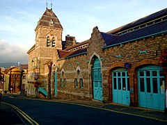 | Ruthin Town Hall Ruthin Town Hall (Welsh: Neuadd y Dref Rhuthun) is a municipal facility in Ruthin, Denbighshire, Wales. It is a Grade II listed building. |
| Ruthin Ruthin is a market town and community in Denbighshire, Wales, in the south of the Vale of Clwyd. The town, castle and St Peter’s Square lie on a hill, skirted by villages such as Pwllglas and Rhewl. The name comes from the colour of sandstone bedrock from which the castle was built. |
| Ruthin Town F.C. Ruthin Town Football Club is a Welsh football club, based in Ruthin, Denbighshire. They currently play in the Cymru North. Ruthin reached the final of the Welsh Cup in 1880 but lost 2-1 to Druids in 1880. |
 | Peers Memorial, Ruthin Peers Memorial is in St Peter’s Square, Ruthin, Denbighshire, Wales. It is designated by Cadw as a Grade II listed building. |
 | Nantclwyd y Dre Nantclwyd y Dre is a Grade 1 listed house in Ruthin, Denbighshire. It is Wales’s oldest dated timbered town house, and is owned by the County and open to the public. |
 | The Morning Star, Ruthin The Morning Star (or The Star Inn), Ruthin was listed as a Grade II building on 16 May 1978. It is directly opposite the Ruthin Gaol and is claimed to be the oldest pub in Ruthin. The inn was originally built in 1639, as a lobby-entrance building with integral rear wing. |
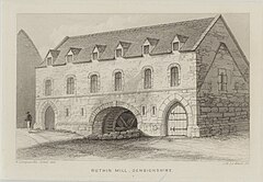 | The Old Mill, Ruthin The Old Mill, Ruthin, Denbighshire, North Wales was designated Grade II listed building on the 24 October 1950. The mill probably dates from around 1300; the building had been used as a garrison chapel. The watermill was removed from the mill during the 1950s. |
 | Ruthin Castle Ruthin Castle (Welsh: Castell Rhuthun) is a medieval castle fortification in Wales, near the town of Ruthin in the Vale of Clwyd. It was constructed during the late 13th century by Dafydd ap Gruffydd, the brother of Prince Llywelyn. Part of the walls still remain and now form part of the Ruthin castle Hotel. |
Visit Ruthin plaques
 1
1
plaques
here Ruthin has 1 physical plaques in tourist plaque schemes for you to explore via Walkfo Ruthin plaques audio map when visiting. Plaques like National Heritage’s “Blue Plaques” provide visual geo-markers to highlight points-of-interest at the places where they happened – and Walkfo’s AI has researched additional, deeper content when you visit Ruthin using the app. Experience the history of a location when Walkfo local tourist guide app triggers audio close to each Ruthin plaque. Explore Plaques & History has a complete list of Hartlepool’s plaques & Hartlepool history plaque map.


 Trying to encourage visitors to Ruthin?