Welcome to Visit Ruardean Places
The Walkfo guide to things to do & explore in Ruardean
 Visit Ruardean places using Walkfo for free guided tours of the best Ruardean places to visit. A unique way to experience Ruardean’s places, Walkfo allows you to explore Ruardean as you would a museum or art gallery with audio guides.
Visiting Ruardean Walkfo Preview
Ruardean is a village in the Forest of Dean, Gloucestershire, England, to the North West of Cinderford. It is situated on a hillside with views west towards the mountains of South Wales. Once it was a centre for iron ore smelting furnaces, forges and coal mines. When you visit Ruardean, Walkfo brings Ruardean places to life as you travel by foot, bike, bus or car with a mobile phone & headphones.
Ruardean Places Overview: History, Culture & Facts about Ruardean
Visit Ruardean – Walkfo’s stats for the places to visit
With 28 audio plaques & Ruardean places for you to explore in the Ruardean area, Walkfo is the world’s largest heritage & history digital plaque provider. The AI continually learns & refines facts about the best Ruardean places to visit from travel & tourism authorities (like Wikipedia), converting history into an interactive audio experience.
Ruardean history
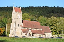
Ruardean was spelt as Ruardyn and was part of Herefordshire. Nowadays the village lies inside Gloucestershire and is part of the Forest of Dean district. St. John the Baptist’s Church, dating from 1111 AD, is the village’s centrepiece and main landmark.
“Who killed the bears?”
Four Frenchmen and their two bears were attacked by an angry mob in Cinderford. Angry mob claimed the bears had killed a child and injured a woman. It soon became clear that the bears did not attack anyone. 13 colliers and labourers appeared before magistrates charged with ill-treating and killing the bears and assaulting the Frenchmen. All but two were found guilty on one or more charges.
Why visit Ruardean with Walkfo Travel Guide App?
 You can visit Ruardean places with Walkfo Ruardean to hear history at Ruardean’s places whilst walking around using the free digital tour app. Walkfo Ruardean has 28 places to visit in our interactive Ruardean map, with amazing history, culture & travel facts you can explore the same way you would at a museum or art gallery with information audio headset. With Walkfo, you can travel by foot, bike or bus throughout Ruardean, being in the moment, without digital distraction or limits to a specific walking route. Our historic audio walks, National Trust interactive audio experiences, digital tour guides for English Heritage locations are available at Ruardean places, with a AI tour guide to help you get the best from a visit to Ruardean & the surrounding areas.
“Curated content for millions of locations across the UK, with 28 audio facts unique to Ruardean places in an interactive Ruardean map you can explore.”
Walkfo: Visit Ruardean Places Map
28 tourist, history, culture & geography spots
Ruardean historic spots | Ruardean tourist destinations | Ruardean plaques | Ruardean geographic features |
| Walkfo Ruardean tourism map key: places to see & visit like National Trust sites, Blue Plaques, English Heritage locations & top tourist destinations in Ruardean | |||
Best Ruardean places to visit
Ruardean has places to explore by foot, bike or bus. Below are a selection of the varied Ruardean’s destinations you can visit with additional content available at the Walkfo Ruardean’s information audio spots:
 | Mitcheldean Meend Marsh Mitcheldean Meend Marsh (grid reference SO647180) is a 0.7-hectare nature reserve in Gloucestershire in the Forest of Dean. The site is listed in the ‘Forest of Dean Local Plan Review’ as a Key Wildlife Site. |
 | Puddlebrook Quarry Puddlebrook Quarry (grid reference SO646183) is a geological Site of Special Scientific Interest in Gloucestershire. The site is listed in the ‘Forest of Dean Local Plan Review’ as a Key Wildlife Site. |
| Scully Grove Quarry Scully Grove Quarry (grid reference SO657186) is a 0.4-hectare (0.99-acre) geological Site of Special Scientific Interest in Gloucestershire. The site is listed in the Forest of Dean Local Plan Review as a Key Wildlife Site (KWS) |
 | Stenders Quarry Stenders Quarry (grid reference SO659183) is a 2.8-hectare (6.9-acre) biological and geological Site of Special Scientific Interest in the Forest of Dean, Gloucestershire, England. The site was known formerly as the Wilderness Cement Work Quarry. |
 | Plump Hill Dolomite Quarry Plump Hill Dolomite Quarry (grid reference SO661171) is a 4.5-hectare (11-acre) nature reserve in Gloucestershire in the Forest of Dean. The site is listed in the ‘Forest of Dean Local Plan Review’ as a Key Wildlife Site (KWS) |
 | Edgehills Quarry Edgehills Quarry (grid reference SO660167) is a 0.4-hectare (0.99-acre) geological Site of Special Scientific Interest in Gloucestershire. The site is listed in the ‘Forest of Dean Local Plan Review’ as a Key Wildlife Site (KWS) |
 | Laymoor Quag Laymoor Quag (grid reference SO644146) is a 3.5-hectare (8.6-acre) nature reserve in the Forest of Dean in Gloucestershire. The site is listed in the ‘Forest of Dean Local Plan Review’ as a Key Wildlife Site (KWS) |
 | Holy Jesus Church, Lydbrook Holy Jesus Church at Lydbrook is a Church of England parish church in Gloucestershire. The church is located in the county of Gloucesterhire. |
Visit Ruardean plaques
 0
0
plaques
here Ruardean has 0 physical plaques in tourist plaque schemes for you to explore via Walkfo Ruardean plaques audio map when visiting. Plaques like National Heritage’s “Blue Plaques” provide visual geo-markers to highlight points-of-interest at the places where they happened – and Walkfo’s AI has researched additional, deeper content when you visit Ruardean using the app. Experience the history of a location when Walkfo local tourist guide app triggers audio close to each Ruardean plaque. Currently No Physical Plaques.


 Trying to encourage visitors to Ruardean?