Welcome to Visit Romiley Places
The Walkfo guide to things to do & explore in Romiley
 Visit Romiley places using Walkfo for free guided tours of the best Romiley places to visit. A unique way to experience Romiley’s places, Walkfo allows you to explore Romiley as you would a museum or art gallery with audio guides.
Visiting Romiley Walkfo Preview
Romiley is a village in the Metropolitan Borough of Stockport, Greater Manchester. Historically part of Cheshire, it borders Marple, Bredbury and Woodley. At the 2011 census, the Romiley ward had a population of 14,139. When you visit Romiley, Walkfo brings Romiley places to life as you travel by foot, bike, bus or car with a mobile phone & headphones.
Romiley Places Overview: History, Culture & Facts about Romiley
Visit Romiley – Walkfo’s stats for the places to visit
With 45 audio plaques & Romiley places for you to explore in the Romiley area, Walkfo is the world’s largest heritage & history digital plaque provider. The AI continually learns & refines facts about the best Romiley places to visit from travel & tourism authorities (like Wikipedia), converting history into an interactive audio experience.
Romiley history

Romiley has four primary schools, four Catholic schools and a Forum Theatre. The Forum Theatre is owned by Stockport Council but is managed by NK Theatre Arts. Secondary education is provided by Werneth School and Harrytown Catholic High School.
Romiley geography / climate
Romiley’s surroundings are semi-rural, although it is a suburb, with fields to the north. Compstall is home to the Etherow Country Park which is the largest country park in Stockport.
Why visit Romiley with Walkfo Travel Guide App?
 You can visit Romiley places with Walkfo Romiley to hear history at Romiley’s places whilst walking around using the free digital tour app. Walkfo Romiley has 45 places to visit in our interactive Romiley map, with amazing history, culture & travel facts you can explore the same way you would at a museum or art gallery with information audio headset. With Walkfo, you can travel by foot, bike or bus throughout Romiley, being in the moment, without digital distraction or limits to a specific walking route. Our historic audio walks, National Trust interactive audio experiences, digital tour guides for English Heritage locations are available at Romiley places, with a AI tour guide to help you get the best from a visit to Romiley & the surrounding areas.
“Curated content for millions of locations across the UK, with 45 audio facts unique to Romiley places in an interactive Romiley map you can explore.”
Walkfo: Visit Romiley Places Map
45 tourist, history, culture & geography spots
Romiley historic spots | Romiley tourist destinations | Romiley plaques | Romiley geographic features |
| Walkfo Romiley tourism map key: places to see & visit like National Trust sites, Blue Plaques, English Heritage locations & top tourist destinations in Romiley | |||
Best Romiley places to visit
Romiley has places to explore by foot, bike or bus. Below are a selection of the varied Romiley’s destinations you can visit with additional content available at the Walkfo Romiley’s information audio spots:

Marple Aqueduct
Marple Aqueduct at Marple, Greater Manchester, is the highest canal aqueduct in England. It was built to carry the lower level of the Peak Forest Canal across the River Goyt. Seven men lost their lives during its construction. The difference in water levels in the river and canal is 90 feet (27.4m) It contains 8,000 cubic yards (6,000 m³) of masonry.

Brabyns Park
Brabyns Park is a public park in Marple Bridge, Stockport, Greater Manchester, England. It is located on the outskirts of the city of Stockport.

Mellor Mill
Mellor Mill, also known as Bottom’s Mill, was a cotton mill in Marple, Greater Manchester built by Samuel Oldknow in 1793. It was a six-storey, 42-foot wide and 210-foot (64 m) long mill. It reached its peak production in 1804, when 10,080 spindles were operating.

Chadkirk
Chadkirk is an area in the Metropolitan Borough of Stockport in Greater Manchester. It is located between the River Goyt and the Peak Forest Canal south of Romiley, east of the A627 road. The site of a former print works on the right bank of the river is now a business park. The ancient woodlands of Kirk Wood and Little Wood have been declared Sites of Biological Importance (SBI)

Chadkirk Chapel
Chadkirk Chapel is a restored historic chapel near Romiley in the Metropolitan Borough of Stockport in Greater Manchester. It is recorded in the National Heritage List for England as a designated Grade II* listed building.

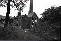
Elder Mill, Romiley
Elder Mill, Romiley was a cotton spinning mill in Romiley, Stockport, Greater Manchester. It was taken over by the Lancashire Cotton Corporation in the 1930s and passed to Courtaulds in 1964.

Torkington
Torkington in Greater Manchester is part of the Metropolitan Borough of Stockport. It is located in the Metropolitan borough of the city, Stockport, and is situated in the North East of the South East of Manchester.

St George’s Church, Hyde
St George’s Church is on Church Street, Hyde, Greater Manchester. It is an active Anglican parish church in the deanery of Mottram, the archdeaconry of Macclesfield and the diocese of Chester. The church is recorded in the National Heritage List for England as a designated Grade II listed building.

Welkin Mill, Lower Bredbury
Welkin Mill, Lower Bredbury is a cotton spinning mill in Stockport, Greater Manchester. It was built in the early years of the 20th century for ring spinning. The 162,000 sq ft (15,100 m) mill occupies a 5.15 acres (2.08 ha) site.
Wood Mill, Woodley
Wood Mill was a mill located by the River Tame in Stockport, Cheshire. Originally built in the early to mid 19th century and used as a bone mill. After 1848 the building was converted to a woollen mill and was rebuilt in 1864. The building was used for colour and chemical manufacturing and demolished in 1964.
Visit Romiley plaques
 6
6
plaques
here Romiley has 6 physical plaques in tourist plaque schemes for you to explore via Walkfo Romiley plaques audio map when visiting. Plaques like National Heritage’s “Blue Plaques” provide visual geo-markers to highlight points-of-interest at the places where they happened – and Walkfo’s AI has researched additional, deeper content when you visit Romiley using the app. Experience the history of a location when Walkfo local tourist guide app triggers audio close to each Romiley plaque. Explore Plaques & History has a complete list of Hartlepool’s plaques & Hartlepool history plaque map.


 Trying to encourage visitors to Romiley?