Welcome to Visit Rochdale Places
The Walkfo guide to things to do & explore in Rochdale
 Visit Rochdale places using Walkfo for free guided tours of the best Rochdale places to visit. A unique way to experience Rochdale’s places, Walkfo allows you to explore Rochdale as you would a museum or art gallery with audio guides.
Visiting Rochdale Walkfo Preview
Rochdale is 5.3 miles (8.5 km) northwest of Oldham and 9.8 miles (15.8 km) northeast of Manchester . It was a boomtown of the Industrial Revolution and was a centre of northern England’s woollen trade . Rochdal rose to prominence in the 19th century as a mill town and centre for textile manufacture . It is the birthplace of the modern Co-operative Movement, founded in 1844 . When you visit Rochdale, Walkfo brings Rochdale places to life as you travel by foot, bike, bus or car with a mobile phone & headphones.
Rochdale Places Overview: History, Culture & Facts about Rochdale
Visit Rochdale – Walkfo’s stats for the places to visit
With 71 audio plaques & Rochdale places for you to explore in the Rochdale area, Walkfo is the world’s largest heritage & history digital plaque provider. The AI continually learns & refines facts about the best Rochdale places to visit from travel & tourism authorities (like Wikipedia), converting history into an interactive audio experience.
Rochdale history
Etymology
The town is recorded as Recedham in the Domesday Book and Rachetham in 1193 . Variations of Rechedham continue into the thirteenth century when the first element’s termination is dropped as Rachedam became Racheham . The Doomsday Book’s rendering of the name led Eilert Ekwall to suggest a derivation from reced, an obscure Old English element meaning “hall” This etymology is described as “highly problematic” and not accepted .
Early history
Castleton is named after a Saxon castle that may have been destroyed by Danes during the 10th and 11th century . Rochdale appears in the Domesday Book of 1086 as Recedham and was described as laying within the hundred of Salford and the county of Cheshire .
Industrial Revolution
The manufacture of woollen cloth, particularly baize, kerseys and flannels, was important from the reign of Henry VIII . By the mid-1800s the woollen trade was declining and cotton trade took advantage of technological developments in spinning and weaving growing in importance . Rochdale rose to prominence during the 19th century as a major mill town and centre for textile manufacture during the Industrial Revolution .
Post-industrial
The first seven series of the BBC school drama Waterloo Road were set in Rochdale between 2006 and 2012 . Most of the out-of-school scenes in the series were filmed around the area . The final scenes to be shot at the Hilltop Primary site were filmed in November 2011 . In April 2012, filming on the eighth series began on location at the former Greenock Academy in Greenock, Scotland .
Rochdale landmarks

Rochdale Town Hall is a Victorian era town hall “widely recognised as being one of the finest municipal buildings in the country” Built in the Gothic Revival style it was inaugurated on 27 September 1871. The building came to the attention of Adolf Hitler who admired it so much that he wished to ship the building, brick-by-brick, to Nazi Germany.
Rochdale geography / climate
Rochdale stands about 450 feet (137 m) above sea level, 9.8 miles (15.8 km) north-northeast of Manchester city centre, in the valley of the River Roch. It forms the fifth largest settlement of the Greater Manchester Urban Area, the United Kingdom’s third largest conurbation.
Divisions and suburbs
Ashworth Balderstone Bamford Bamford Belfield Belfield Buckley Buersil Burnedge Caldershaw Castleton Cronkeyshaw Cutgate Deeplish Falinge Fieldhouse Firgrove Foxholes Halfacre Hamer Healey Hurstead .
Why visit Rochdale with Walkfo Travel Guide App?
 You can visit Rochdale places with Walkfo Rochdale to hear history at Rochdale’s places whilst walking around using the free digital tour app. Walkfo Rochdale has 71 places to visit in our interactive Rochdale map, with amazing history, culture & travel facts you can explore the same way you would at a museum or art gallery with information audio headset. With Walkfo, you can travel by foot, bike or bus throughout Rochdale, being in the moment, without digital distraction or limits to a specific walking route. Our historic audio walks, National Trust interactive audio experiences, digital tour guides for English Heritage locations are available at Rochdale places, with a AI tour guide to help you get the best from a visit to Rochdale & the surrounding areas.
“Curated content for millions of locations across the UK, with 71 audio facts unique to Rochdale places in an interactive Rochdale map you can explore.”
Walkfo: Visit Rochdale Places Map
71 tourist, history, culture & geography spots
Rochdale historic spots | Rochdale tourist destinations | Rochdale plaques | Rochdale geographic features |
| Walkfo Rochdale tourism map key: places to see & visit like National Trust sites, Blue Plaques, English Heritage locations & top tourist destinations in Rochdale | |||
Best Rochdale places to visit
Rochdale has places to explore by foot, bike or bus. Below are a selection of the varied Rochdale’s destinations you can visit with additional content available at the Walkfo Rochdale’s information audio spots:

Stanney Brook
Stanney Brook originates in the Burnedge area of Shaw and Crompton. It flows through Milnrow into Rochdale before joining the River Roch at Newbold Brow. Its name derives from the Lancashire dialect word “stanner”
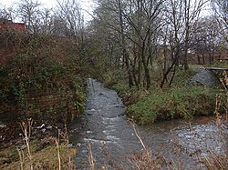
Hey Brook
Hey Brook is a watercourse in Rochdale, Greater Manchester. It originates at the confluence of Buckley Brook and Syke Brook. It flows through Wardleworth to the River Roch.

St John the Baptist Church, Rochdale
St John the Baptist Church is a Roman Catholic Parish church in Rochdale, Greater Manchester. It was founded in 1830, and built in 1927. It is situated on the corner of Maclure Road and Dowling Street.

Rochdale (ancient parish)
Rochdale was an ecclesiastical parish of early-medieval origin in northern England. At its zenith, it occupied 58,620 acres (237 km) of land amongst the South Pennines. It straddled the historic county boundary between Lancashire and the West Riding of Yorkshire.
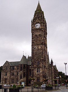
Rochdale Town Hall
Victorian-era municipal building in Rochdale, Greater Manchester, was built in 1871. Built in Gothic Revival style at a cost of £160,000 (£15 million in 2021) It is recorded in the National Heritage List for England as a Grade I listed building. It functions as the ceremonial headquarters of the Metropolitan Borough Council and houses local government departments.

Rochdale Pioneers Museum
The Rochdale Pioneers Museum is housed in the building where the Equitable Pioneers Society started trading on 21 December 1844. The museum includes a recreation of the original shop, containing its rudimentary furniture, scales, items that were sold at the store, etc.

Spodden Valley asbestos controversy
72 acres (290,000 m) of land in Spodden Valley in Rochdale, England, formerly used by Turner Brothers Asbestos Company. Site of world’s largest asbestos textile factory was sold to MMC Estates, a property developer. MMC submitted a planning application to build an “urban village” consisting of 650 homes, a children’s daycare centre and a business park on the site. However, asbestos containing materials were abundantly visible on the ground, and local residents claimed that there were numerous asbestos dumping sites across the area.

Touchstones Rochdale
Touchstones Rochdale is an art gallery, museum, local studies centre, visitor information centre and café. The first part of the building was opened as a library in 1884 with the museum and gallery being added in 1903 and extended in 1913. It became an art and heritage centre in 2003.

Rochdale Infirmary
Rochdale Infirmary is an acute general hospital in Greater Manchester. It is managed by the Pennine Acute Hospitals NHS Trust.

HM Prison Buckley Hall
Buckley Hall Prison is a Category C male prison in the Buckley district of Rochdale in North West England. It is operated by Her Majesty’s Prison and Probation Service.
Visit Rochdale plaques
 29
29
plaques
here Rochdale has 29 physical plaques in tourist plaque schemes for you to explore via Walkfo Rochdale plaques audio map when visiting. Plaques like National Heritage’s “Blue Plaques” provide visual geo-markers to highlight points-of-interest at the places where they happened – and Walkfo’s AI has researched additional, deeper content when you visit Rochdale using the app. Experience the history of a location when Walkfo local tourist guide app triggers audio close to each Rochdale plaque. Explore Plaques & History has a complete list of Hartlepool’s plaques & Hartlepool history plaque map.


 Trying to encourage visitors to Rochdale?