Welcome to Visit Risinghurst Places
The Walkfo guide to things to do & explore in Risinghurst
 Visit Risinghurst places using Walkfo for free guided tours of the best Risinghurst places to visit. A unique way to experience Risinghurst’s places, Walkfo allows you to explore Risinghurst as you would a museum or art gallery with audio guides.
Visiting Risinghurst Walkfo Preview
Risinghurst is just outside the Eastern Bypass Road which forms part of the Oxford ring road. It is about 1 mile east of the centre of Headington and 3 miles (4.8 km) east of Oxford city centre. During the 1930s some 600 homes were built in sets of semi-detached units; two rows of shops were built on Downside Road and more at the end of Green Road. When you visit Risinghurst, Walkfo brings Risinghurst places to life as you travel by foot, bike, bus or car with a mobile phone & headphones.
Risinghurst Places Overview: History, Culture & Facts about Risinghurst
Visit Risinghurst – Walkfo’s stats for the places to visit
With 104 audio plaques & Risinghurst places for you to explore in the Risinghurst area, Walkfo is the world’s largest heritage & history digital plaque provider. The AI continually learns & refines facts about the best Risinghurst places to visit from travel & tourism authorities (like Wikipedia), converting history into an interactive audio experience.
Risinghurst history
The name Risinghurst ‘rising ground towards the hurst or wooded hill’ reflects the fact that Risinghurst was built on gently rising land running upwards towards Shotover Hill. Through part of the Estate runs the course of the Roman road between Silchester and Towcester. The Kilns itself is so-named because kilns were excavated here that are thought to date back to the Roman period. Evidence of Romano-British occupation was discovered during clay-quarrying in the late-19th century (these pits have now become lakes). Finds recorded in 1898 include building stones, gravel floors, and pottery dated mostly to the 3rd and 4th centuries but including some 2nd-century Samian ware. The surface of a ‘probable road’ was also sectioned, lying parallel to the main road but over 100 yards (91 m) to the east; this consisted of a spread of stones about 20 feet (6.1 m) wide and about 1 foot (30 cm) thick in the centre, tapering to ‘almost nothing at the edges’. Coins recovered from the site and recorded by Harding in 1939 ranged from issues of Tiberius (AD 14–37) to Honorius (AD 395–423). In the 17th century a small settlement grew up in what is now the southeast corner of the Estate—the houses are still there. Brick and tile works were established (in the middle of the 19th century three were located off what we now know as Kiln Lane) and that remained in operation until the early part of the 20th century. The rest of what is now Risinghurst was farmland. Magdalen Farm was located roughly where the top end of Stanway and Collingwood Roads now are. The northern part of Risinghurst was one large field; the southern part was a number of smaller fields. On the site where Nielsen’s HQ now sits was a house called Shotover Lodge in the middle of the 19th century but Forest Lodge by the turn of the 20th century. Up until the late 18th century, the Oxford to London road ran over Shotover Hill. Then a turnpike was opened on a new route further north with upwards of 80 coaches plus the Mail coach making the trip to London daily. This is today’s A40 road that forms the northern boundary of Risinghurst. An 18th century turnpike milestone (Oxford 3, London 51) can still be seen on the central reservation near the Thornhill Park and Ride. (Thornhill itself is both the name of the farm to the east of Risinghurst and the hill that rises towards Shotover.) Bounding the western edge of Risinghurst is Green Road. Maps from the 19th century show that it was a road at that time and it is probably older; its original name was Toot Hill Butts as the road ran through an ancient field of that name. In the mid to late 1930s the bulk of the Estate was built primarily by Benfield and Loxley (an Oxford building firm started in the late 19th century and still in existence) and sold between £350 to £500 in 1936. Most of the houses in Risinghurst are still these pebble-dashed semi-detached 1930s three-bedroom houses, although the newer houses behind Nielsen’s UK headquarters date from the 1970s, some smaller ex-council houses date from the late 1980s, and 18 houses built in 1997 are on the site of a coppice. The Estate was built primarily to house the increasing number of workers then employed at Morris Motors (by 1937 Morris Motors was the largest motor manufacturer in Europe); until relatively recently, most of the home-owners were still likely to be employed in the automotive industry. In 1958 work started on the Eastern Bypass—a plan had been under discussion for 30 years and when Risinghurst was built, a gap was left between it and Headington Quarry so that a road could be built. This dual carriageway cut off Risinghurst from Headington Quarry. The latter, until then, had been seen as part of the same district by the residents. Now Risinghurst was very much an island with two major trunk roads running along two sides and open countryside along the rest. In 1968 the turn into Risinghurst from the dual carriageway was blocked off causing anger among residents and letters to the local press such as this: Does the Oxford City Corporation really think that by closing the Risinghurst turn for cars, mopeds etc it will reduce accident figures for that stretch of road. In my view, cyclists and moped riders returning from the factories will be jostling to get through the ridicuously small gap. I don’t think that many men, especially on mopeds, are going to continue up the Green Road Roundabout, and then on to the A40… The OCC eventually capitulated. The 2001 Census showed that of 840 people in employment who lived in Risinghurst, 165 worked in healthcare/social work (no doubt due to the proximity of the John Radcliffe Hospital), 130 in real estate/renting/business activities, 121 in education, and only 105 in manufacturing. The Green Road or Headington roundabout that lies on the north-eastern corner has become over the years a nationally known landmark, the County’s worst accident black-spot and also a traffic-jam nightmare. In 2006, it was ripped-up and replaced at a cost of £2m by a new ‘hamburger’ design. In the past, the Estate was bisected by the City Boundary. The part of the Estate within the Bullingdon Rural District Council (the ‘County’) enjoyed grass verges—lacking in the ‘City’ sector. The divide meant that children in the two administrative parts went to different schools—this led to little intermingling between families. Both parts also had their own playing fields to further add to the division. However, in 1992, the whole of Risinghurst was brought into the City. There is no school in Risinghurst. In the past, infants and primary aged children who lived in the ‘County’ attended Sandhills County Primary School. If they passed their 11-plus, they went to either Lord Williams’s Grammar School in Thame, or Holton Park Girls Grammar School, Wheatley. If they failed, they went to the Harlow School in Marston. (It is worth noting that prior to 1947, only children living city-half were able to go on to a grammar school education.) Those who lived in the ‘City’, went to primary schools in Headington Quarry; the secondary schools were either Bayswater or Littlemore Grammar School. Nowadays, the whole of Risinghurst is in the Sandhills Community Primary School and Wheatley Park catchment areas. When the estate was first built no provision for a community centre was made. In the late 1940s a residents group obtained an old Army building from Major Miller’s Estate near Wheatley. This was dismantled brick by brick and rebuilt on a corner of the allotments off Kiln Lane. During the 1950s regular events that were held there included whist drives, bingo, beetle drives and old time dancing. Saturday night became the youth night with a weekly hop.
Why visit Risinghurst with Walkfo Travel Guide App?
 You can visit Risinghurst places with Walkfo Risinghurst to hear history at Risinghurst’s places whilst walking around using the free digital tour app. Walkfo Risinghurst has 104 places to visit in our interactive Risinghurst map, with amazing history, culture & travel facts you can explore the same way you would at a museum or art gallery with information audio headset. With Walkfo, you can travel by foot, bike or bus throughout Risinghurst, being in the moment, without digital distraction or limits to a specific walking route. Our historic audio walks, National Trust interactive audio experiences, digital tour guides for English Heritage locations are available at Risinghurst places, with a AI tour guide to help you get the best from a visit to Risinghurst & the surrounding areas.
“Curated content for millions of locations across the UK, with 104 audio facts unique to Risinghurst places in an interactive Risinghurst map you can explore.”
Walkfo: Visit Risinghurst Places Map
104 tourist, history, culture & geography spots
Risinghurst historic spots | Risinghurst tourist destinations | Risinghurst plaques | Risinghurst geographic features |
| Walkfo Risinghurst tourism map key: places to see & visit like National Trust sites, Blue Plaques, English Heritage locations & top tourist destinations in Risinghurst | |||
Best Risinghurst places to visit
Risinghurst has places to explore by foot, bike or bus. Below are a selection of the varied Risinghurst’s destinations you can visit with additional content available at the Walkfo Risinghurst’s information audio spots:
 | St Anthony of Padua, Oxford The Church of St Anthony of Padua, Oxford is a yellow brick-built Catholic church . It is located in suburb of Headington, east Oxford, Oxfordshire, England . |
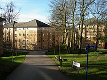
 | Cotuit Hall Cotuit Hall is part of the EF International Academy’s campus in Oxford, England . Until 2011 it was one of the halls of residence at Oxford Brookes University . |
 | Parson’s Pleasure Parson’s Pleasure in the University Parks at Oxford, England, was a secluded area for male-only nude bathing on the River Cherwell . It was located next to the path on the way to Mesopotamia at the south-east corner of the Parks . The facility closed in 1991 and the area now forms part of the parks . |
 | Headington Hill Hall Headington Hill Hall was built in 1824 and the Morrell family remained in residence for 114 years . It became the home to Pergamon Press and to disgraced tycoon Robert Maxwell . It currently houses Oxford Brookes School of Law . |
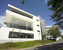
 | Cheney Student Village Cheney Student Village is one of the nine halls of residence at Oxford Brookes University . It houses 750 students in single study bedrooms with en suite shower rooms and self catered kitchens . |
 | Holywell Manor, Oxford Holywell Manor is a historic building in central Oxford, England, in the parish of Holywell . It currently houses some of Balliol College’s postgraduate students . |
 | South Park, Oxford South Park is a park on Headington Hill in east Oxford, England . It is the largest park within Oxford city limits . A good view of the city centre with its spires and towers of Oxford University can be obtained at the park’s highest point . |
 | Old Road Campus Old Road Campus is south of Old Road, in Headington, east Oxford, England . Churchill Hospital, a teaching hospital managed by the Oxford University Hospitals NHS Foundation Trust, is to the south . |
 | St Bartholomew’s Chapel, Oxford St Bartholomew’s Chapel, or Bartlemas Chapel, is a small, early-14th-century chapel, built as part of a leper hospital in Oxford, England. Founded in the early 12th century by Henry I, for twelve sick persons and a chaplain, it was granted to Oriel College by Edward III in 1328. |
 | Helen & Douglas House Helen & Douglas House is a registered hospice charity (no. 1085951) based in Oxford, England. It provides palliative, respite, end-of-life and bereavement care to life-limited children and their families. |
Visit Risinghurst plaques
 24
24
plaques
here Risinghurst has 24 physical plaques in tourist plaque schemes for you to explore via Walkfo Risinghurst plaques audio map when visiting. Plaques like National Heritage’s “Blue Plaques” provide visual geo-markers to highlight points-of-interest at the places where they happened – and Walkfo’s AI has researched additional, deeper content when you visit Risinghurst using the app. Experience the history of a location when Walkfo local tourist guide app triggers audio close to each Risinghurst plaque. Explore Plaques & History has a complete list of Hartlepool’s plaques & Hartlepool history plaque map.


 Trying to encourage visitors to Risinghurst?