Welcome to Visit Retford Places
The Walkfo guide to things to do & explore in Retford
 Visit Retford places using Walkfo for free guided tours of the best Retford places to visit. A unique way to experience Retford’s places, Walkfo allows you to explore Retford as you would a museum or art gallery with audio guides.
Visiting Retford Walkfo Preview
Retford is one of the oldest market towns in England having been granted its first charter in 1105. It lies on the River Idle and the Chesterfield Canal passes through its centre. In 1878 an Act of Parliament extended the borough of East Retford to include Ordsall, West Retford and part of the parish of Clarborough. When you visit Retford, Walkfo brings Retford places to life as you travel by foot, bike, bus or car with a mobile phone & headphones.
Retford Places Overview: History, Culture & Facts about Retford
Visit Retford – Walkfo’s stats for the places to visit
With 35 audio plaques & Retford places for you to explore in the Retford area, Walkfo is the world’s largest heritage & history digital plaque provider. The AI continually learns & refines facts about the best Retford places to visit from travel & tourism authorities (like Wikipedia), converting history into an interactive audio experience.
Retford history
Origins of the name

The origins of the town’s name are unknown but consensus seems to conclude that it gets its name from an ancient ford crossing the River Idle. A common explanation of the name is that the river water was tinged red due to the frequent crossing of people and livestock disturbing the clay river bed. Other traditions include that it refers to the reeds that are plentiful in the river.
Settlement
The first land settled was on the western side of the ford, this area being less liable to flooding. However, as the community grew it spread to occupy land on the other bank of the river, and it was this eastern part of the town that eventually became more important; hence Retford’s alternative (and, for administrative purposes, still official) name of East Retford. The centre of Retford is characterised by a large Market Square surrounded by Georgian period architecture. The Retford Conservation Area contains the historic cores of both West and East Retford, which sit either side of the River Idle. The Conservation Area also extends southwards up to and including the 18th century Chesterfield Canal. The town also includes the small villages and hamlets that are adjacent to it, which have effectively become suburbs of the town. These include Ordsall and Babworth. Evidence of early human activity around Retford stretches back to the Mesolithic period, with archaeological evidence of human activity in the area including a Mesolithic flint tool found in Ordsall, an axe from the Neolithic era (New Stone Age) from Little Morton and a Neolithic polished flint axe discovered near the River Idle at Tiln. A Bronze Age spearhead was found near Whinney Moor Lane and Romano-British crop marks are visible around Babworth. The area Retford is situated in was on the border of the territories of the Brigantes and the Corieltauvi during the Iron Age period. It is likely that the existence of Retford is partly owed to its water resources, in the form of both the river Idle (and its crossing) and the wells that are dotted around the area that are either still in existence or can be identified from placename evidence. These include Spa Common, Cobwell Road (named after the Cob Well) and the ancient well at Welham (called ‘Wellun’ in the Domesday Book). Between Retford and Grove there are a range of earthworks of unknown date. They may be pre-historic and/or Roman. There is evidence of a medieval moated site or possible motte & bailey construction. This site was later reinforced during the English Civil War. The wood here is known as Castle Hill Wood. Roman-era artefacts are rare in Retford, although 1st–2nd century items were found at a site on Carolgate in 1922. The remains of a group of 1st–3rd century buildings were found at Babworth in 1981. A coin hoard was found at Little Morton that was dated to the 3rd century, and Roman artefacts and pottery fragments have been found at Tiln (Stroud, 2001). Evidence of Roman field patterns were identified by Derrick Riley of Sheffield University in the 1970s and 80s. Nottingham University archaeological researchers have said that during the 5th century and even into the 6th century, North Nottinghamshire was likely populated by “British communities with a sub-Romano-British culture”. Retford has traditionally been placed within the Anglo-Saxon kingdom of Mercia because it is situated within Nottinghamshire. More recent historical research suggests that the South of Nottinghamshire and North Nottinghamshire may have had very different cultures. North Nottinghamshire, including Retford, belonged to an area called Bernet-seatte, which later became Bernesedelaue and then Bassetlaw. This territory is now thought to have been “substantially British”. It practised, for example, partible inheritance, had British placenames and there is relatively little Anglo-Saxon material. West and East Markham seem to have been on the boundaries of this territory (maerc means boundary). It is not known if Bernet-seatte extended across the whole of North Nottinghamshire, or whether the Kingdom of Lindsey controlled the East of this area (Retford and Retford rural district). What is known is that this corridor of land was seen as strategic, which is why several notable battles were fought in the area between the kings of Northumbria and Mercia. The strategic Battle of the River Idle (617) was fought in or near Retford. The Battle of the River Idle was significant in establishing Rædwald’s power, such that Bede called him “Rex Anglorum” (King of the Angles). Various battlesites have been suggested including at Retford, Eaton and Bawtry. No evidence of a battlefield has been found in any of these sites, although according to Hunt this led to a saying: “The River Idle was foul with the blood of Englishmen”,. A variant local tradition says this was the origin of the name “Redforde”. Placename evidence in Retford does suggest Viking settlement. Many of the streets in the centre of town are -gates, deriving from the Old Norse gata, which means street. In Retford there are streets named Moorgate, Bridgegate, Chapelgate, Churchgate and Carolgate. Grove Street was previously known as Newgate and Lidgett Lane was originally Hildgeat or Hildgate. The Reverend WP McFarren (1947) wrote that Bridgegate was previously spelt Briggate (1340) suggesting the river had a bridge from a very early date. Moorgate contains both Anglo-Saxon (AS) and Old Norse (ON) elements, deriving from AS mor and ON gate. Its literal meaning is ‘miry street’. This is a reference to the beck that used to cross it. (This beck was progressively contained within a culvert and is no longer visible for most of its course into the Idle.) Carolgate is derived from the ON karla (karl) + ON gate. A karl was a freeman. WP McFarren (1947) also mentions a ‘Kynegesgate’ (Kingsgate), which is now lost. Piercy mentions Carhillgate (p. 146). Timber piles were found in Retford in 1995 on the Western bank of the Idle at Bridgegate, which were dated to 947-1030 AD. In the Domesday Book Retford was recorded as Redforde, and joined to Odesthorpe (now unknown). It appears to have been the property or fee of Roger de Busli, who was granted large amounts of land in what had been Anglo-Saxon Mercia. In 1105, East Retford was established as a royal borough by Henry I. This would have made it the second most important settlement after Nottingham itself in the county. According to Marcombe (1993), the intention was for East Retford “to compete with the trading privileges of Blyth Priory and to exploit the market opportunities of north Nottinghamshire”. In 1225, the burgesses of Retford are said to have taken over the collection of ‘river tolls’ from Blyth Priory. Retford was granted a total of 17 Royal Charters (including the Letters Patent of 1225 that granted it the right to levy tolls on travellers in North Nottinghamshire) up to 1607. There is some controversy over when it was granted its first charter with Piercy (1828) suggesting it was granted in 1246 by King Henry III, which allowed an 8-day annual fair to be held. However, Ballard & Tait (1923) and Dolby (1997) say that there is no existing historical evidence to support this, making the 1259 charter the earliest known to be granted. The 1313 charter has survived and is now held in the Bassetlaw Museum. The first town hall or ‘moot hall’ was built in 1388 and demolished in 1754. It is believed that this may have been situated in what is now known as Cannon Square. The hall was built of timber and faced east. On the ground floor of this building was the Shambles. At that time, the present Market Square was possibly used for cattle/horses, with Marcombe suggesting this was the site of the ‘beast market’ in the Tudor period. 16th century The 16th century began was an unlucky period for Retford. At this time, the majority of buildings were of timber and thatch construction. However, most of these were destroyed by fires. In 1528 a fire destroyed more than three-quarters of the buildings in East Retford. By 1552 Retford’s population had dropped to 700. In 1558 there was an outbreak of Plague, which caused 300 deaths in East Retford and killed half the people of West Retford. A fire in 1585 was so profound that the people of Worksop raised money for ‘the poor men of the late burned town of Retford’. Yet another fire struck in 1631 and caused £1,300 worth of damage. 17th century The Civil War seems to have largely bypassed Retford, although W.E. Doubleday wrote in the Nottinghamshire Guardian (1947) that “During the Civil War a Roundhead force from Retford attempted to capture the mansion occupied by the Royalist Gervase Lee, but the attack was beaten off and the besiegers compelled to retreat as a party of Cavalier troops from Newark approached rapidly”. Charles I was also said to have stayed in the house of Mr Lane, a lawyer, on 20 August 1645. He was on his way from Doncaster and set off the following day to Lord Danecourt’s in Newark.(Wilmshurst 1908) In 1657 there was a Great Storm, which destroyed the steeple and Chantries of St Swithun’s Church. This was restored in 1658 at a cost of £3,648. 18th century Retford was more troubled during the Jacobite rising of 1745. Cornelius Brown records that in 1745 an army of 6,000 English and Hessian troops camped on Wheatley Hills and the soldiers marched through Retford and used East Retford (St Swithun’s) church as a stable. This was The Derbyshire Blues, which had been formed to protect Derby under the aegis of the Duke of Devonshire, but which retreated 50 miles to Retford when reports reached Derby that the Jacobites had a 9,000 strong army. On 23 August 1750, an earthquake struck Retford. In 1757 the Town Clerk successfully petitioned for the Great North Road to be diverted to run through the town, which led to an Act of Parliament (1760) authorising the re-routing of the Great North Road between Barnby Moor and Markham Moor to pass through Retford. The new turnpike was completed in 1765–66 and after this the town prospered. (Piercy 1828) Then in 1777 the Chesterfield Canal was built by James Brindley through the town. During the 18th century improvements were made to West Retford Bridge – the main bridge over the Idle which is where the original ford was situated. Moss says that the first stone bridge was erected in 1659 and that it was thirteen feet wide and had five arches. Wilmshurst records that in 1752 the bridge was “widened for carts” and was replanked, suggesting that at least part of the construction was still wooden. In 1794 it was rebuilt on stone arches, according to Wilmshurst, with Moss adding that it was thirty-one feet wide at this time. Moss notes that before 1776 a toll was charged to cross the river and that to the north side were the corn mills mentioned in the Domesday Book that were once owned by Hubert de Burgh. The 1794 bridge was later to be replaced in 1886 with the current bridge, which Wilmshurst says was because of floods: “In consequence of these continuous Floods the Corporation demolished the great Mill, and the narrow 5-arched Bridge, and erected present wide girder Bridge in West Retford”. Moss (1908) says this bridge (which he dates as 1868) cost £1,500 to construct. Moss (1908) tells us that in 1760 Retford’s ducking stool was used for the last time. He says it was situated at the end of a narrow street opposite the Post Office that led down the River Idle. The use of the ducking stool was granted in 1279 by Edward I and was used for the last time to punish a “Scotswoman of violent temperament” called “Dame Barr”, who was ducked for offending John White by “throwing the contents of her snuff-box in his face, and uttering opprobrious terms”. 19th century In 1801 there were 5,999 people, which rose to 12,340 by 1901. Many improvements were made including the direct London to York railway being routed via the borough in 1849. In 1831, the Gas Works was built by James Malam and gaslights were lit in the town for the first time on 22 December 1831. The Square was lit by a cast iron light bearing five gas lamps at that time. The Gas Works became a target on 2 September 1916 when a German Zeppelin dropped 14 bombs on Retford. The Retford Times (8 September 1916) noted that bombs were dropped from Zeppelin L-13 into the orchard that surrounded the Gas Works, and although there wasn’t a direct hit, shrapnel hit the sides of the gasometers setting them on fire. This fire was said to be so intense that according to the Retford Times “apples [were] baked on the trees, and roosting wild birds roasted alive”. The Nottingham Daily Express (8 September 1916) reported that the Zeppelin then departed “at great altitude and terrific speed”. The manager and his family were said to have had a very lucky escape as the shrapnel also hit their house. John Hook records that the Zeppelin left Retford at 1.05am, dropping a further bomb just south of Lea. One of the replacement gasometers later exploded on 16 March 1955, injuring 7 men and killing the manager. According to reports in The Retford Times, flames shot 200 feet into the air. The gasometers were finally dismantled when the town was connected to North Sea gas in the 1970s. In 1878 an Act of Parliament added the parishes of West Retford and Ordsall, and part of the parish of Clarborough to East Retford. 20th century Weeks before the outbreak of war, the Retford Times reported that “the town really turned on the charm” when King George V visited Retford in 1914. This is said to have included a large pavilion in the market square that was decorated with flowers, three different renderings of the National Anthem plus dancing and fireworks. One of the main changes in Retford during the 20th century was the opening of King’s Park in 1938. The park commemorated the reign of George V and the coronation of George VI. The site was presented to the Borough by Mrs M J Huntsman of West Retford Hall, with £2000 towards the cost of the park layout raised by public subscription. According to war records, Retford was bombed six times during World War II – on 26th September 1940, 30th October 1940, 16th December 1940, 15th March 1941 (2 injuries), 15th August 1941 and 25th August 1941. Although it was on the bombing route to higher value targets such as Sheffield and Rotherham, was surrounded by airforce bases, and had the intersection between two railway lines, no-one was killed in the raids and the town escaped the war virtually unscathed. The Great North Road was diverted around the town in 1961 and part of the route through the town is now pedestrianised. The 1971 census showed the population to be 18,407. By 2001 the population had grown to 22,000 (Nicholson, 2008), with a large proportion living on housing estates in Ordsall, Hallcroft and Spital Hill.
Political history

Retford is one of the oldest boroughs in England and was mentioned in the Domesday Book of 1086 as ‘Redeforde’. Henry I established the borough in 1105, and it gained a Royal Charter in 1246, when Henry III granted the right to a fair. This was later extended to holding a Saturday Market by Edward I in 1275. The granting of Royal Charters was important because it enabled Retford to self-govern and become independent of interference from the Sheriff of Nottingham. A total of 17 charters (including the Letters Patent of 1225) are believed to have been granted to East Retford up to 1607. Retford’s civic traditions are maintained by Charter Trustees and its coat of arms consists of two rampant choughs, which were taken from an old seal of the Borough. The crest is based on the design on a Mace presented to the Borough in 1679 by Sir Edward Neville, with few changes. A small shield replaces the original rose, upon which the lion rests its paw. The shield features a deed which references the Boroughs ancient Royal Charters. The unicorns are from the heraldry of Lord Galway, whose ancestors were High Stewards of the Borough. The shells are from the arms of Rt Hon FJ Savile Foljambe, appointed High Steward 1880. Since 1974, Retford has been part of the district of Bassetlaw which was formed by the merger of the boroughs of Worksop and East Retford, as well as most of Worksop Rural District and East Retford Rural District. Bassetlaw is named after the historic Anglo-Saxon Bassetlaw Wapentake of Nottinghamshire. From 1316 Retford was entitled to two sitting MPs. Although by 1330 it was begging to be excused the privilege on the grounds of poverty, inability to afford the cost of paying the heavy expenses of the MPs long journeys to and from the capital. The petition was granted and it was to be several generations (1571) before Retford was represented in the Lower Chamber again. Historically, Retford was notorious as one of the most corrupt boroughs – a so-called ‘rotten’ borough – in England and was considered to be in the gift of the Duke of Newcastle. There were vigorous debates in Parliament over whether to transfer Retford’s franchise to one of the larger unrepresented towns such as Manchester or Birmingham. Hansard records that during the House of Lords debates on the Disfranchisement Bill, the town had an active committee, led by a couple of attorneys and meeting at the Turk’s Head Inn, who were trying to make the borough seem even more corrupt than it was to ensure its extinction. One of the committee members was later seen wearing a gold watch, apparently presented in gratitude by well-wishers in Birmingham. Viscount Howick objected to the disenfranchisement of Retford not on the basis that the accusations of corruption were not true, but that it punished the innocent as well as the guilty and ignored the fact that many boroughs were equally corrupt. They thought that East Retford ought to be partially sacrificed, in order to prevent the whole system of corruption from being overturned. Just as in a bullfight a cloak is dropped to turn aside the rage of the mad animal, while his assailant prepares more securely to destroy him. If the public were ignorant of the undue means by which a large majority of the Members of that House obtained their seats in it, they might declaim against the venality of the voters of East Retford; but, notorious as these circumstances were, he thought it better to pass over the present case in silence till they were prepared to deal with others equally flagitious.— Hansard record of Viscount Howick’s speech in the House, 1830, HC Deb 11 February 1830 vol 22 cc334-63 The 1830 Act extended the borough’s boundaries to encompass the Wapentake of Bassetlaw (which included the whole of the northern end of Nottinghamshire, including the town of Worksop). All those within this area who were qualified to vote in the county elections were given votes for East Retford. Within a year, Parliament was debating the Great Reform Bill, but the extended boundaries meant Retford could retain its seats until in 1885 the Municipal Borough of East Retford was reformed and the constituency replaced by an identically delineated single-member county constituency – Bassetlaw. Retford and its rural district was removed from Bassetlaw in 1983 and transferred to the redrawn Newark constituency. The boundaries were redrawn again in 2010, with Retford returning to the Bassetlaw parliamentary constituency (although some of the Retford rural district remains in the Newark constituency such as Markham Moor). The Bassetlaw constituency was held by Labour from 1929 until 2019 when the sitting Labour MP (John Mann) stood down. The current MP is Conservative Brendan Clarke-Smith who won the seat with the biggest swing from one party to another in the entire country in the General Election 2019. For administrative purposes Retford is regarded as being within the East Midlands region, though it has strong cultural and economic links to South Yorkshire. Retford has twinning associations with: Pfungstadt (Germany). Aurillac (France) since 1980. Farmers Branch (USA) since 1980.
Historians

John Shadrach Piercy was born in Rillington, near Malton and moved to Retford in 1822 to teach at the National School (a school that traditionally had strong links with St Swithun’s church) on Grove Street. Piercy’s work contains references to material that has subsequently been lost. B.J. Biggs was the Principal Lecturer in History at Eaton Hall College and a keen local historian.
Retford economy & business
Current economy of Retford
Retford has a strong economy mainly consisting of services with some light industry. Retail, health, manufacturing, education and accommodation are major employers. In 2013, Retford’s town centre had an empty shop rate of only 9%, 5% less than national average.
Historic economy of Retford
Retford did not experience the large-scale industrial growth of nearby towns and remained primarily a rural market town. Historically, it traded agricultural produce, but has also been a producer of hats, sail-cloth, rope, sack bags, paper and leather.
The role of women in Retford’s economy

Until the Black Death, most beer in the UK was produced by women. Women have played an important role in the economy of Nottinghamshire. Many historic Retford pubs were recorded as having female managers. Women-owned businesses were relatively common in Retford.
Why visit Retford with Walkfo Travel Guide App?
 You can visit Retford places with Walkfo Retford to hear history at Retford’s places whilst walking around using the free digital tour app. Walkfo Retford has 35 places to visit in our interactive Retford map, with amazing history, culture & travel facts you can explore the same way you would at a museum or art gallery with information audio headset. With Walkfo, you can travel by foot, bike or bus throughout Retford, being in the moment, without digital distraction or limits to a specific walking route. Our historic audio walks, National Trust interactive audio experiences, digital tour guides for English Heritage locations are available at Retford places, with a AI tour guide to help you get the best from a visit to Retford & the surrounding areas.
“Curated content for millions of locations across the UK, with 35 audio facts unique to Retford places in an interactive Retford map you can explore.”
Walkfo: Visit Retford Places Map
35 tourist, history, culture & geography spots
Retford historic spots | Retford tourist destinations | Retford plaques | Retford geographic features |
| Walkfo Retford tourism map key: places to see & visit like National Trust sites, Blue Plaques, English Heritage locations & top tourist destinations in Retford | |||
Best Retford places to visit
Retford has places to explore by foot, bike or bus. Below are a selection of the varied Retford’s destinations you can visit with additional content available at the Walkfo Retford’s information audio spots:

Bassetlaw Museum
The Bassetlaw Museum documents the history of North Nottinghamshire from the earliest times to the present day. It is situated on Grove Street, Retford, Nottinghamshire.
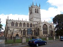
St Swithun’s Church, East Retford
St Swithun’s Church is a Grade II* listed Church of England parish in the Diocese of Southwell and Nottingham in East Retford, Nottinghamshire.

Sloswicke’s Hospital
Sloswicke’s Hospital is an almshouse in East Retford, Nottinghamshire, England. It is located on the outskirts of Nottinghamshire.

St Saviour’s Church, Retford
St Saviour’s Church, Retford is a Grade II* listed parish church in the Church of England in Retford. The church is located in the centre of the town of Retford in the area.

St Michael the Archangel’s Church, Retford
St Michael the Archangel’s Church is a Grade II* listed parish church in Retford, Nottinghamshire, England. It is located in the centre of Retford in the area of the Retford area.

West Retford Hotel, Nottinghamshire
West Retford Hotel in Nottinghamshire is Grade II listed on the English Heritage Register. It was built in the 18th Century, possibly around 1740 and was the home of many notable people. Today it is a hotel which provides accommodation, restaurant and bar facilities.

Retford United F.C.
Retford United Football Club (also known as the Badgers) are an English football club based at Cannon Park in Retford, Nottinghamshire. They currently play in the Central Midlands Football League.

Retford F.C.
Retford Football Club is a football club in Retford, Nottinghamshire. They currently play in the Northern Counties East League Division One.

Welham, Nottinghamshire
Welham is a hamlet in the civil parish of Clarborough and Welham, of Bassetlaw district, in the county of Nottinghamshire. It is 130 miles north of London, 28 miles north east of the city of Nottingham, and 2 miles north-east of the market town of Retford.

Clarborough and Welham
Clarborough and Welham is a civil parish in the Bassetlaw district, in the county of Nottinghamshire. It is 130 miles north of London, 28 miles north east of the city of Nottingham, and 2 miles north-east of Retford. In 2011 the parish had a population of 1088.
Visit Retford plaques
 0
0
plaques
here Retford has 0 physical plaques in tourist plaque schemes for you to explore via Walkfo Retford plaques audio map when visiting. Plaques like National Heritage’s “Blue Plaques” provide visual geo-markers to highlight points-of-interest at the places where they happened – and Walkfo’s AI has researched additional, deeper content when you visit Retford using the app. Experience the history of a location when Walkfo local tourist guide app triggers audio close to each Retford plaque. Currently No Physical Plaques.


 Trying to encourage visitors to Retford?