Welcome to Visit Reigate Places
The Walkfo guide to things to do & explore in Reigate
 Visit Reigate places using Walkfo for free guided tours of the best Reigate places to visit. A unique way to experience Reigate’s places, Walkfo allows you to explore Reigate as you would a museum or art gallery with audio guides.
Visiting Reigate Walkfo Preview
Reigate is one of four towns in the borough of Reigate and Banstead. It is located at the foot of the North Downs and extends over part of the Greensand Ridge. Reigate was the site of a medieval castle, and has been a market town since the medieval period. When you visit Reigate, Walkfo brings Reigate places to life as you travel by foot, bike, bus or car with a mobile phone & headphones.
Reigate Places Overview: History, Culture & Facts about Reigate
Visit Reigate – Walkfo’s stats for the places to visit
With 36 audio plaques & Reigate places for you to explore in the Reigate area, Walkfo is the world’s largest heritage & history digital plaque provider. The AI continually learns & refines facts about the best Reigate places to visit from travel & tourism authorities (like Wikipedia), converting history into an interactive audio experience.
Reigate history
Early history

The earliest evidence of human activity in the Reigate area is a triangular stone axe from the Paleolithic. The eight barrows on Reigate Heath are thought to date from the same period. During the Roman period, the Doods Road area was a centre for tile making. The former name Cherchefelle suggests that the most recent period of permanent settlement in Reigate began in Anglo-Saxon times.
Governance
Reigate appears in Domesday Book of 1086 as Cherchefelle. Settlement included two mills worth 11s 10d, land for 29 plough teams, woodland and herbage for 140 swine. The manor rendered £40 per year in 1086 and the residents included 67 villagers and 11 smallholders. The non-corporate Borough of Reigate, covering roughly the town centre, was formed in 1295.
Reigate Castle

Reigate Castle was built in the late 11th or early 12th century, most likely by William de Warenne, 2nd Earl of Surrey. It was originally constructed of timber, but the curtain walls were rebuilt in stone around a century later. A water-filled moat was dug into the Gault clay on the north side and a dry ditch was excavated around the remainder.
Reigate Priory

William de Warenne, the fifth Earl of Surrey, is thought to have founded the Augustinian priory at Reigate before his death in 1240. The priory was created as a sub-manor of Reigate and was granted several local farms including one in each of Salford and Horley. At the time of its dissolution in 1536, Reigate Priory was the least wealthy of all Surrey religious houses.
Transport and communications

In medieval times, the main road north from Reigate followed Nutley Lane, climbing Colley Hill in the direction of Kingston upon Thames, from where produce and manufactured items could be moved via the River Thames. The manor of Reigate was responsible for maintaining the roads in the local area, but repairs were carried out infrequently and improvements were often only funded by private donations. The first turnpike in Surrey was authorised by Parliament in 1697, to improve the road south from Woodhatch towards Crawley.
Economy and commerce
From much of its early history, Reigate was primarily an agricultural settlement. In 1623 the total area of arable land was around 4,500 acres (1,800 ha) The manor began to specialise in the production of oatmeal for the Royal Navy in the early 17th century. Reigate has two surviving windmills: a post mill on Reigate Heath and a tower mill on Wray Common.
Residential development
Reigate began to expand following the arrival of the railway lines in the 1840s. A new settlement, initially known as Warwick Town, had become established on land owned by Sarah Greville, Countess of Warwick in the 1820s and 1830s. Redhill expanded eastwards towards the Reigate town centre and the two towns are now contiguous.
Reigate culture & places
Art
Reigate Priory Museum holds an early-16th century portrait of John Lymden, the final Prior of Reigate. Town Hall holds several artworks, including paintings by Henry Tanworth Wells (1828—1903), George Leon Little (1862—1941) and George Hooper (1910—1994)
Literature
Reigate is the setting for the Sherlock Holmes short story The Adventure of the Reigate Squire. It is one of 12 stories featured in The Memoirs of Sherlock Holmes by Sir Arthur Conan Doyle.
Reigate toponymy
Reigate is thought to mean “open space by the hill or barrow” The name “Reigate” first appears in written sources in the 1190s. The name may derive from Old English rǣge meaning “roe deer” and Middle English gate.
Reigate geography / climate

The town centre is, save for the castle, focused on Bell Street, leading south, and a long High Street/West Street conservation area. The swathe of land from the town southwards is sometimes grouped together as the Gatwick Diamond, M23 corridor or Crawley Urban Area. These three largely synonymous areas are interspersed with Metropolitan Green Belt land.
Hamlets and neighbourhoods

Skimmington includes eight pre-historic tumuli (bowl barrows), two in one close group, several within the golf club. Woodhatch is the southern suburb of Reigate with 3 parades of shops. Western Parade is adjacent to the London to Brighton road, which is the only road towards the south from Reigate excluding the motorway network.
Geology
Woodhatch lies on the Weald Clay, a sedimentary rock that was deposited in the early Cretaceous. Reigate Heath and the town centre are on quartz-rich Folkestone Beds and the water-filled part of the castle moat is dug into narrow band of clay present in the sandstone.
Why visit Reigate with Walkfo Travel Guide App?
 You can visit Reigate places with Walkfo Reigate to hear history at Reigate’s places whilst walking around using the free digital tour app. Walkfo Reigate has 36 places to visit in our interactive Reigate map, with amazing history, culture & travel facts you can explore the same way you would at a museum or art gallery with information audio headset. With Walkfo, you can travel by foot, bike or bus throughout Reigate, being in the moment, without digital distraction or limits to a specific walking route. Our historic audio walks, National Trust interactive audio experiences, digital tour guides for English Heritage locations are available at Reigate places, with a AI tour guide to help you get the best from a visit to Reigate & the surrounding areas.
“Curated content for millions of locations across the UK, with 36 audio facts unique to Reigate places in an interactive Reigate map you can explore.”
Walkfo: Visit Reigate Places Map
36 tourist, history, culture & geography spots
Reigate historic spots | Reigate tourist destinations | Reigate plaques | Reigate geographic features |
| Walkfo Reigate tourism map key: places to see & visit like National Trust sites, Blue Plaques, English Heritage locations & top tourist destinations in Reigate | |||
Best Reigate places to visit
Reigate has places to explore by foot, bike or bus. Below are a selection of the varied Reigate’s destinations you can visit with additional content available at the Walkfo Reigate’s information audio spots:
![]()
SES Water
SES Water is the UK water supply company to its designated area of east Surrey, West Sussex, west Kent and south London. An area of 322 square miles (830 km) extends from Morden and South Croydon in the north to Gatwick Airport in the south, and from Cobham and Dorking in the west to Edenbridge and Bough Beech in the east.

Wray Common Mill, Reigate
Wray Common Mill is a grade II* listed tower mill at Reigate, Surrey, England. It has been converted to residential use.

St John’s, Redhill
St John’s is in its wider definition one of the three ecclesiastical parishes that make up Redhill, Surrey. The small elevated residential community occupies a conservation area circled by Earlswood and wooded Redhill Common.
![]()
Earlswood railway station (Surrey)
Earlswood is on the Brighton Main Line, 21 miles 50 chains (34.8 km) down the line from London Bridge via Redhill and south of the junction between the Redhill line and Quarry line. Train services are provided by Thameslink and Southern.

Royal Earlswood Hospital
The Royal Earlswood Hospital was the first establishment to cater specifically for people with developmental disabilities. Previously they had been housed either in asylums for the mentally ill or in workhouses.

London Defence Positions
The London Defence Positions were a late 19th century scheme of earthwork fortifications in the south-east of England. Designed to protect London from foreign invasion landing on the south coast. The positions were a carefully surveyed contingency plan for a line of entrenchments.
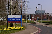
East Surrey Hospital
East Surrey Hospital is a National Health Service hospital in the Whitebushes area to the south of Redhill, in Surrey, England. It is managed by the Surrey and Sussex Healthcare NHS Trust.

Reigate Town Hall
Reigate Town Hall is the meeting place of Reigate and Banstead Borough Council. The town hall is a Grade II listed building. It is a municipal building in Castlefield Road, Reigate, Surrey.

Buckland Windmill
Buckland Windmill is a grade II listed smock mill at Buckland, Surrey, England. It is the only surviving wind saw mill in the United Kingdom.
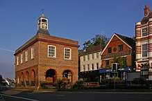
Old Town Hall, Reigate
The Old Town Hall is a municipal building in the High Street, Reigate, Surrey, England. It is a Grade II* listed building.
Visit Reigate plaques
 1
1
plaques
here Reigate has 1 physical plaques in tourist plaque schemes for you to explore via Walkfo Reigate plaques audio map when visiting. Plaques like National Heritage’s “Blue Plaques” provide visual geo-markers to highlight points-of-interest at the places where they happened – and Walkfo’s AI has researched additional, deeper content when you visit Reigate using the app. Experience the history of a location when Walkfo local tourist guide app triggers audio close to each Reigate plaque. Explore Plaques & History has a complete list of Hartlepool’s plaques & Hartlepool history plaque map.


 Trying to encourage visitors to Reigate?