Welcome to Visit Rayners Lane Places
The Walkfo guide to things to do & explore in Rayners Lane
 Visit Rayners Lane places using Walkfo for free guided tours of the best Rayners Lane places to visit. A unique way to experience Rayners Lane’s places, Walkfo allows you to explore Rayners Lane as you would a museum or art gallery with audio guides.
Visiting Rayners Lane Walkfo Preview
Rayners Lane is a suburban district in Harrow that forms the western part of Harrow. Located between Pinner and West Harrow, it takes its name from a road in the area. When you visit Rayners Lane, Walkfo brings Rayners Lane places to life as you travel by foot, bike, bus or car with a mobile phone & headphones.
Rayners Lane Places Overview: History, Culture & Facts about Rayners Lane
Visit Rayners Lane – Walkfo’s stats for the places to visit
With 76 audio plaques & Rayners Lane places for you to explore in the Rayners Lane area, Walkfo is the world’s largest heritage & history digital plaque provider. The AI continually learns & refines facts about the best Rayners Lane places to visit from travel & tourism authorities (like Wikipedia), converting history into an interactive audio experience.
Rayners Lane history
Rayners Lane was originally called Bourne Lane as it crossed several streams including the Yeading Brook. During the first half of the nineteenth century the area was in the hands of the Rayner family, who owned a farm. The area was drastically built up between 1929 and 1938 by Harrow’s biggest interwar housebuilder T.F. Nash, who created a shopping parade on Alexandra Avenue.
Why visit Rayners Lane with Walkfo Travel Guide App?
 You can visit Rayners Lane places with Walkfo Rayners Lane to hear history at Rayners Lane’s places whilst walking around using the free digital tour app. Walkfo Rayners Lane has 76 places to visit in our interactive Rayners Lane map, with amazing history, culture & travel facts you can explore the same way you would at a museum or art gallery with information audio headset. With Walkfo, you can travel by foot, bike or bus throughout Rayners Lane, being in the moment, without digital distraction or limits to a specific walking route. Our historic audio walks, National Trust interactive audio experiences, digital tour guides for English Heritage locations are available at Rayners Lane places, with a AI tour guide to help you get the best from a visit to Rayners Lane & the surrounding areas.
“Curated content for millions of locations across the UK, with 76 audio facts unique to Rayners Lane places in an interactive Rayners Lane map you can explore.”
Walkfo: Visit Rayners Lane Places Map
76 tourist, history, culture & geography spots
Rayners Lane historic spots | Rayners Lane tourist destinations | Rayners Lane plaques | Rayners Lane geographic features |
| Walkfo Rayners Lane tourism map key: places to see & visit like National Trust sites, Blue Plaques, English Heritage locations & top tourist destinations in Rayners Lane | |||
Best Rayners Lane places to visit
Rayners Lane has places to explore by foot, bike or bus. Below are a selection of the varied Rayners Lane’s destinations you can visit with additional content available at the Walkfo Rayners Lane’s information audio spots:
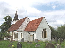 | St Mary with St Richard, Northolt St Mary the Virgin is a 13th-century Anglican parish church in Northolt, London. It is one of London’s smallest churches, its nave measuring 15 yards (14 m) by 8 yards (7.3 m) The church was built around 1290 and expanded over the centuries. The chancel was added in 1521 and the spired bell tower in the 16th century. |
 | Harrow bus station Harrow bus station serves Harrow in the London Borough of Harrow, Greater London, England. The station is owned and maintained by Transport for London. The main operators at the bus station are London Sovereign, Metroline and Arriva London. Buses go from Harrow as far afield as Watford, Ealing, Edgware, Brent Cross, Golders Green, Wembley, Wembley and Ruislip. |
Visit Rayners Lane plaques
 17
17
plaques
here Rayners Lane has 17 physical plaques in tourist plaque schemes for you to explore via Walkfo Rayners Lane plaques audio map when visiting. Plaques like National Heritage’s “Blue Plaques” provide visual geo-markers to highlight points-of-interest at the places where they happened – and Walkfo’s AI has researched additional, deeper content when you visit Rayners Lane using the app. Experience the history of a location when Walkfo local tourist guide app triggers audio close to each Rayners Lane plaque. Explore Plaques & History has a complete list of Hartlepool’s plaques & Hartlepool history plaque map.


 Trying to encourage visitors to Rayners Lane?