Welcome to Visit Radcliffe, Greater Manchester Places
The Walkfo guide to things to do & explore in Radcliffe, Greater Manchester
 Visit Radcliffe, Greater Manchester places using Walkfo for free guided tours of the best Radcliffe, Greater Manchester places to visit. A unique way to experience Radcliffe, Greater Manchester’s places, Walkfo allows you to explore Radcliffe, Greater Manchester as you would a museum or art gallery with audio guides.
Visiting Radcliffe, Greater Manchester Walkfo Preview
Radcliffe is a market town in the Metropolitan Borough of Bury. It lies in the Irwell Valley 6.5 miles (10 km) north-northwest of Manchester. The disused Manchester Bolton & Bury Canal bisects the town. Evidence of Mesolithic, Roman and Norman activity has been found in the area. When you visit Radcliffe, Greater Manchester, Walkfo brings Radcliffe, Greater Manchester places to life as you travel by foot, bike, bus or car with a mobile phone & headphones.
Radcliffe, Greater Manchester Places Overview: History, Culture & Facts about Radcliffe, Greater Manchester
Visit Radcliffe, Greater Manchester – Walkfo’s stats for the places to visit
With 83 audio plaques & Radcliffe, Greater Manchester places for you to explore in the Radcliffe, Greater Manchester area, Walkfo is the world’s largest heritage & history digital plaque provider. The AI continually learns & refines facts about the best Radcliffe, Greater Manchester places to visit from travel & tourism authorities (like Wikipedia), converting history into an interactive audio experience.
Radcliffe, Greater Manchester history
Toponymy
The name Radcliffe is derived from the Old English words read and clif, meaning “the red cliff or bank”, on the River Irwell in the Irwell Valley. The Domesday Book records the name as “Radeclive” and other archaic spellings. The Radcliffe family took its name from the town.
Early history
Archaeological excavations in 1949 at Radcliffe Ees found evidence of pre-historic activity, suggesting a lake village site. The first human settlements in the area are thought to have been as far back as 6,000BC during the Mesolithic period. During the Roman period, a Roman road passed through the area on a south-east to north-west axis; tracing an alignment with the modern border between Radcliffe and Bury.
Textiles and the Industrial Revolution

The first documented reference to industry in Radcliffe is after 1680, in the Radcliffe parish registers, which make increasing mention of occupations such as woollen webster (weaving), linen webster, and whitster (bleacher). These were cottage industries which worked alongside local agriculture. In 1780 Robert Peel built the first factory in the town, several hundred yards upstream from Radcliffe Bridge (at the end of Peel Street). With a weir and goit providing motive power for a water wheel, the factory was built for throstle spinning and the weaving of cotton—a relatively new introduction to Britain. The water wheel proved to be insufficient, and so around 1804 the goit was extended. The weir (known as Rectory Weir) was made from timber. Conditions were poor; the mill employed child labour bought from workhouses in Birmingham and London. Children were boarded on an upper floor of the building, and bound until they reached the age of 21. They were unpaid, and were kept locked up each night. Shifts were typically 10–10.5 hours in length, and children returning from a day shift would sleep in the same bed as children leaving for a night shift. Peel himself admitted that conditions at the mill were “very bad”. In 1784 an outbreak of typhoid prompted Lord Grey de Wilton to inform the magistrates of the Salford Hundred; keen to prevent the spread of the disease to neighbouring towns and villages, they sent doctors to assess the situation. Their recommendations included leaving the windows of the mill open at night, fumigation of rooms with tobacco (as this was thought to discourage disease), regular cleaning of rooms and toilets and occasional bathing of children. The report forced the magistrates, led by Thomas Butterworth Bayley, to abandon the practice of binding parish apprentices to any mill not adhering to these conditions. The report also prompted Peel to introduce an Act of Parliament to improve factory hygiene, which later became the Factory Act of 1802. Over time, conditions at the mill improved; in the mid-1790s the physician John Aikin, a critic of the factory system, praised working conditions at the mill, and in 1823 inspections by local magistrates of conditions in mills across the county revealed that unlike many others, the factory at Radcliffe was adhering to all requirements of the Factory Acts. The underlying coal measures throughout the parish were a valuable source of fuel. Radcliffe already had an established textile industry before the arrival of steam power. The first recorded instance of coal getting in the North West of England was in 1246, when Adam de Radeclyve was fined for digging de minera on common land in the Radcliffe area. Coal outcroppings were not uncommon; as recently as 1936 members of the public were seen carrying away large pieces of coal from a seam revealed by the landslip caused when the Manchester Bolton & Bury Canal breached at Ladyshore. Mining was initially limited to bell pits until the arrival of steam engines, which along with improved ventilation, made possible much deeper pits. The earliest known local use of such an engine was in 1792 at Black Cat Colliery. The parish of Radcliffe was once home to as many as 50 pits, but with the exceptions of Outwood Colliery and Ladyshore Colliery, all were either exhausted or closed by the end of the 19th century. During the 1926 General Strike many striking miners illegally took coal from exposed seams around the Coney Green area of the town, to sell to local housewives. In the 1950s to the north of the town the National Coal Board did some open cast mining near Radcliffe Moor Road, but the last legal instance of coal mining in Radcliffe was between 1931 and 1949, close to Bury and Bolton Road. The transformation of the area from an industry based upon water power, to one based upon steam power, may not have been without problems. A story in W. Nicholl’s History and Traditions of Radcliffe (1900) tells of a “great crowd” of protesters from Bury who marched on Bealey’s Works, demanding that work be halted. James Booth ordered the gates closed, gave the ringleaders £5, and promised to halt work the next day. The crowd then marched on other businesses within the town before heading along the canal to Bolton, at which point they were apparently turned back by news of approaching soldiers. There were many smaller textile concerns in the parish. Thomas Howarth owned a cottage in Stand Lane from where he sent yarn to be dyed and sized. He made his own warps which were weaved in the town. He would then travel to Preston and Kendal where drapers would purchase his products. His nephews founded A. & J. Hoyle’s Mill in Irwell Street, which employed power weaving to produce their specialities in Ginghams and shirting. The mill closed in 1968. Messrs Stott & Pickstone’s Top Shop on Stand Lane was the first company to employ powered looms and spinning around 1844. Many of their employees would eventually leave to start their own businesses, such as Spider Mill, built by Robert and William Fletcher, and John Pickstone. This mill closed around 1930. Radcliffe was at one time home to around 60 textile mills and 15 spinning mills, along with 18 bleachworks of which the Bealey family were prominent owners. However, the textile industry was not the town’s major employer; other industries such as mining and paper making were also important sources of employment. Mount Sion Mill along Sion Street was founded in the early 19th century and during the First World War manufactured guncotton. A weir was constructed along with a goit, used to turn a water wheel which powered a beam engine to pump water to the reservoirs above. Radcliffe became well known for its paper industry; its mills included the East Lancashire Paper Mill and Radcliffe Paper Mill. The former was founded by the Seddon family on 29 March 1860, along the banks of the Irwell. Its construction provided much-needed employment: in the 1860s living standards within the town were poor, and local mills often operated on “short time”. A reduction in the demand for coal had placed many colliers out of work, and the Lancashire Cotton Famine was starving Lancashire of raw materials, especially cotton. Soup kitchens were opened by local benefactors, and many local residents were on poor relief. The mill began producing low grade paper and newsprint, moving on to other products including high quality printing and writing papers. Radcliffe Paper Mill was formed during the First World War, when it took over from a paper mill and a pipe plant. It originally produced paper suitable for roofing felt, to cater for a national shortage. After World War II the mill employed over 600 people and produced 70,000 tons of paper annually. British Plaster Board Industries (BPB) took over the company in 1961. Other industries in the town included brick making and chimney pot manufacture. Raw materials were sourced from local collieries. In Mill Street carts, waggons, and bicycles were manufactured from 1855, and elsewhere motor vehicles were also produced until the late 1950s. John Cockerill moved to the town from Haslingden before leaving for continental Europe to become the founder of Cockerill-Sambre. James Cockerill, employed Radcliffe man William Yates as his manager. Several foundries and machine manufacturers were located around the town, including Dobson and Barlow at Bradley Fold, and Wolstenholme’s along Bridgewater Street. Munitions, aircraft and tank components were manufactured during the Second World War. Chemicals were manufactured by companies such as Bealey’s and J. & W. Whewell.
Post-industrial history
From the 1950s Radcliffe’s textile industry went into terminal decline. Both the town’s largest paper mills have now been closed and demolished. Since deindustrialisation the local population has continued to grow. In 1974 the town became part of the Metropolitan Borough of Bury.
Radcliffe, Greater Manchester culture & places

Radcliffe’s wealth as a mill town gave rise to many outlets for entertainment of its population. Several cinemas were built in the town, including the Picturedrome in Water Street and an Odeon cinema, built in 1937. Whittaker Street public baths built in 1898 and demolished in 1971. A public library was opened in 1907 on a site donated by Andrew Carnegie. A museum was located in the upper rooms of Close House before it was demolished in 1969.
Radcliffe, Greater Manchester economy & business
Population and employment change
In 1921 2,394 men and 3,680 women were employed in the textile industry, but in 1951 this had dropped to 981 and 1,852. By 2001, from a working population of 15,972 between the ages of 16–74 only six people worked in mining.
Radcliffe, Greater Manchester landmarks

Radcliffe Tower is all that remains of an early 15th-century stone-built manor house. The construction of a nearby tithe barn is not documented, but it was probably built between 1600 and 1720. The town also has two Grade II* listed buildings; Dearden Fold Farmhouse and Radcliffe Cenotaph.
Radcliffe, Greater Manchester geography / climate
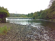
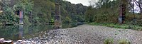
Radcliffe lies in the Irwell Valley on the course of the River Irwell. The town lies 170 miles (274 km) northwest of central London. The larger towns of Bury and Bolton lie to the northeast and northwest. The river provides a source of water for local industry.
Why visit Radcliffe, Greater Manchester with Walkfo Travel Guide App?
 You can visit Radcliffe, Greater Manchester places with Walkfo Radcliffe, Greater Manchester to hear history at Radcliffe, Greater Manchester’s places whilst walking around using the free digital tour app. Walkfo Radcliffe, Greater Manchester has 83 places to visit in our interactive Radcliffe, Greater Manchester map, with amazing history, culture & travel facts you can explore the same way you would at a museum or art gallery with information audio headset. With Walkfo, you can travel by foot, bike or bus throughout Radcliffe, Greater Manchester, being in the moment, without digital distraction or limits to a specific walking route. Our historic audio walks, National Trust interactive audio experiences, digital tour guides for English Heritage locations are available at Radcliffe, Greater Manchester places, with a AI tour guide to help you get the best from a visit to Radcliffe, Greater Manchester & the surrounding areas.
“Curated content for millions of locations across the UK, with 83 audio facts unique to Radcliffe, Greater Manchester places in an interactive Radcliffe, Greater Manchester map you can explore.”
Walkfo: Visit Radcliffe, Greater Manchester Places Map
83 tourist, history, culture & geography spots
Radcliffe, Greater Manchester historic spots | Radcliffe, Greater Manchester tourist destinations | Radcliffe, Greater Manchester plaques | Radcliffe, Greater Manchester geographic features |
| Walkfo Radcliffe, Greater Manchester tourism map key: places to see & visit like National Trust sites, Blue Plaques, English Heritage locations & top tourist destinations in Radcliffe, Greater Manchester | |||
Best Radcliffe, Greater Manchester places to visit
Radcliffe, Greater Manchester has places to explore by foot, bike or bus. Below are a selection of the varied Radcliffe, Greater Manchester’s destinations you can visit with additional content available at the Walkfo Radcliffe, Greater Manchester’s information audio spots:
 | Nob End Nob End is the site of a former waste tip near Little Lever and Kearsley, in Greater Manchester. It is now a Site of Special Scientific Interest and Local Nature Reserve. |
 | Moses Gate Country Park Moses Gate Country Park, part of which is also known as Crompton Lodges, is a 750 acre (300 hectare) site situated at Moses Gate in the Croal and Irwell Valleys. It is a Local Nature Reserve. |
 | Kearsley Mill Kearsley Mill is a 240,000 sq ft (22,000 m), late period cotton mill located in the small village of Prestolee, Greater Manchester. A near complete example of Edwardian mill architecture, the building functions as headquarters for a number of businesses. |
 | Ladyshore Colliery Ladyshore Colliery, originally named Back o’ th Barn, was situated on the Irwell Valley fault on the Manchester Coalfield in Little Lever, Lancashire. Founded by Thomas Fletcher Senior, the colliery opened in the 1830s and mined several types of coal. |
 | Lever Bank Bleach Works Lever Bank Bleach Works was a Bleach Works at Ladyshore, near Little Lever, Bolton. The works was owned by Thomas Ridgway & Sons. Former British Prime Minister Tony Blair would appear to be a direct descendant of this family. |
 | Wet Earth Colliery Wet Earth Colliery was a coal mine located on the Manchester Coalfield, in Clifton, Greater Manchester. The colliery has a unique place in British coal mining history; apart from being one of the earliest pits in the country, it is the place where engineer James Brindley made water run uphill. |
 | Clifton Country Park The park comprises 119 acres (48 hectares) of wooded area, fields and lakes. Industrial heritage is also a feature of the park, the remains of Wet Earth Colliery can be found in the woods, along with Fletcher’s Canal. |
 | Redvales Redvales is a residential district to the south of Bury town centre in Greater Manchester. The population of the Bury Ward at the 2011 census was 11,483. |
 | Pilkington’s Lancastrian Pottery & Tiles Pilkington’s Lancastrian Pottery & Tiles was a manufacturer of tiles, vases and bowls. The company was established in 1892 at Clifton Junction, near Pendlebury, Lancashire. |
Visit Radcliffe, Greater Manchester plaques
 2
2
plaques
here Radcliffe, Greater Manchester has 2 physical plaques in tourist plaque schemes for you to explore via Walkfo Radcliffe, Greater Manchester plaques audio map when visiting. Plaques like National Heritage’s “Blue Plaques” provide visual geo-markers to highlight points-of-interest at the places where they happened – and Walkfo’s AI has researched additional, deeper content when you visit Radcliffe, Greater Manchester using the app. Experience the history of a location when Walkfo local tourist guide app triggers audio close to each Radcliffe, Greater Manchester plaque. Explore Plaques & History has a complete list of Hartlepool’s plaques & Hartlepool history plaque map.


 Trying to encourage visitors to Radcliffe, Greater Manchester?