Welcome to Visit Queen’s Park, Glasgow Places The Walkfo guide to things to do & explore in Queen’s Park, Glasgow
Visit Queen’s Park, Glasgow places using Walkfo for free guided tours of the best Queen’s Park, Glasgow places to visit. A unique way to experience Queen’s Park, Glasgow’s places, Walkfo allows you to explore Queen’s Park, Glasgow as you would a museum or art gallery with audio guides.
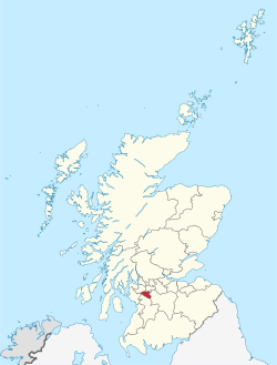
Visiting Queen’s Park, Glasgow Walkfo Preview Queen’s Park is a 60-hectare (148-acre) park situated 2+1/2 miles (4 km) south of the city centre. The park gives its name to a nearby railway station and several other local businesses and institutions. When you visit Queen’s Park, Glasgow, Walkfo brings Queen’s Park, Glasgow places to life as you travel by foot, bike, bus or car with a mobile phone & headphones.
Queen’s Park, Glasgow Places Overview: History, Culture & Facts about Queen’s Park, Glasgow
Visit Queen’s Park, Glasgow – Walkfo’s stats for the places to visit
With 303 audio plaques & Queen’s Park, Glasgow places for you to explore in the Queen’s Park, Glasgow area, Walkfo is the world’s largest heritage & history digital plaque provider. The AI continually learns & refines facts about the best Queen’s Park, Glasgow places to visit from travel & tourism authorities (like Wikipedia), converting history into an interactive audio experience.
Queen’s Park, Glasgow history
Queen’s Park was designed by Sir Joseph Paxton, also responsible for noted public parks in London, Liverpool, Birkenhead and the grounds of the Spa Buildings at Scarborough. The park was dedicated to the memory of Mary, Queen of Scots – Mary lost the Battle of Langside near the park. It is surrounded by several residential city districts, mostly consisting primarily of tenements.
Why visit Queen’s Park, Glasgow with Walkfo Travel Guide App?
You can visit Queen’s Park, Glasgow places with Walkfo Queen’s Park, Glasgow to hear history at Queen’s Park, Glasgow’s places whilst walking around using the free digital tour app. Walkfo Queen’s Park, Glasgow has 303 places to visit in our interactive Queen’s Park, Glasgow map, with amazing history, culture & travel facts you can explore the same way you would at a museum or art gallery with information audio headset. With Walkfo, you can travel by foot, bike or bus throughout Queen’s Park, Glasgow, being in the moment, without digital distraction or limits to a specific walking route. Our historic audio walks, National Trust interactive audio experiences, digital tour guides for English Heritage locations are available at Queen’s Park, Glasgow places, with a AI tour guide to help you get the best from a visit to Queen’s Park, Glasgow & the surrounding areas.
“Curated content for millions of locations across the UK, with 303 audio facts unique to Queen’s Park, Glasgow places in an interactive Queen’s Park, Glasgow map you can explore.”
Walkfo Queen’s Park, Glasgow tourism map key: places to see & visit like National Trust sites, Blue Plaques, English Heritage locations & top tourist destinations in Queen’s Park, Glasgow
Best Queen’s Park, Glasgow places to visit
Queen’s Park, Glasgow has places to explore by foot, bike or bus. Below are a selection of the varied Queen’s Park, Glasgow’s destinations you can visit with additional content available at the Walkfo Queen’s Park, Glasgow’s information audio spots:
Mansewood Mansewood (Scots: Mansewid) is a residential district in the Scottish city of Glasgow. It is situated south of the River Clyde and is surrounded by the districts of Eastwood, Hillpark, Pollokshaws in Glasgow and Thornliebank and Giffnock.
East Renfrewshire East Renfrewshire is one of 32 council areas of Scotland . Until 1975, it formed part of the county of Renfreyshire for local government purposes . It was formed in 1996 as a successor to the Eastwood district, with the Levern Valley being annexed .
Muirend Muirend is situated about 4 miles (6.5 km) south of Glasgow city centre. The G44 postcode was rated as the most desirable area of Scotland to live in. Neighbouring areas include Cathcart, Merrylee and Newlands.
Cathcart Cemetery Cathcart Cemetery is a cemetery in East Renfrewshire, Scotland, which was opened in 1878 . It is named after the nearby neighbourhood of Cathcart on the southern outskirts of Glasgow, but does not actually fall within the city boundaries .
Strathbungo Strathbungo grew up as a small village built along the Pollokshaws Road, one of the main arteries leading southwards from the centre of Glasgow, adjoined by the Camphill Estate, now part of Queens Park. The feudal superiors, the Maxwells of Pollok, preferred the name Marchtown, and this name is seen on some old maps.
St Andrew’s Cross, Glasgow St Andrew’s Cross, also known as Eglinton Toll, is a road junction in the south side of Glasgow, Scotland. The junction is known as the St Andrew Cross.
Tradeston Tradeston (Scots: Tredstoun) is a small district in the Scottish city of Glasgow adjacent to the city centre on the south bank of the River Clyde.
Moorepark, Glasgow Moorepark is a small area in the Scottish city of Glasgow. Situated south of the River Clyde and part of the former Burgh of Govan. It was colloquially referred to as ‘Wine Alley’ during the 20th century.
Sandyford, Glasgow Sandyford is north of the River Clyde and forms part of the western periphery of Glasgow. Formerly the name of a ward under Glasgow Town Council in the early 20th century. It is within a continuous area of dense urban development bordering several other neighbourhoods.
Athletes’ Village (Glasgow 2014) The Athletes Village for the 2014 Commonwealth Games was situated on a 35-hectare (86-acre) site, in the east end of Glasgow. The site was used as accommodation for up to 8,000 athletes and officials from all over the Commonwealth nations. After the games, the site was further developed and has up to 1,400 homes, a portion of which are available for social rental.
Visit Queen’s Park, Glasgow plaques
55 plaques hereQueen’s Park, Glasgow has 55 physical plaques in tourist plaque schemes for you to explore via Walkfo Queen’s Park, Glasgow plaques audio map when visiting. Plaques like National Heritage’s “Blue Plaques” provide visual geo-markers to highlight points-of-interest at the places where they happened – and Walkfo’s AI has researched additional, deeper content when you visit Queen’s Park, Glasgow using the app. Experience the history of a location when Walkfo local tourist guide app triggers audio close to each Queen’s Park, Glasgow plaque. Explore Plaques & History has a complete list of Hartlepool’s plaques & Hartlepool history plaque map.
Experience Queen’s Park, Glasgow audio walks & tours
Walkfo guides for things to do / places to visit in Queen’s Park, Glasgow allows exploration as you would do an art gallery or museum. Walk close to one of Queen’s Park, Glasgow’s 303 historic places & our digital tour guide will create an audio story for that spot. With headphone connected, you can explore Queen’s Park, Glasgow freely by foot, bike or bus – with your own personal tour guide in your pocket.
Explore Queen’s Park, Glasgow Map App
Our visit Queen’s Park, Glasgow map shows you things-to-do & places you can visit in Queen’s Park, Glasgow & surrounding areas using the Walkfo digital audio tour guide app. Each spot has plaque, building, street or area information on history, culture or tourism.
You can set your Walkfo’s Queen’s Park, Glasgow tourist map to find historic & tourism spots within 1km, 3km & 5km of the Queen’s Park, Glasgow centre, depending on how far you plan to explore whilst you visit Queen’s Park, Glasgow area at LONG:-4.267759, LAT:55.830433.
Walkfo App
Walkfo
Walkfo is free to download & use (for a limited time period), so if you are looking to explore Queen’s Park, Glasgow, go to your App Store to search for “Walkfo” or follow a links below and install on your mobile phone. Walkfo is designed for use with headphones or AirPods, so you can walk & explore whilst learning about the things around you without digital distraction.
Things to do & visit in Queen’s Park, Glasgow / surrounding areas
● Kennishead ● Hutchesons’ GSFP ● Hutchesons Aloysians ● Eastwood, Glasgow ● Giffnock Synagogue ● Eastwood, Strathclyde ● Mansewood ● Hillpark ● East Renfrewshire ● Diocese of Glasgow and Galloway ● Auldhouse, Glasgow ● Glasgow Hutchesons Aloysians RFC ● Glasgow Southern RFC ● Newlands, Glasgow ● Pollok House ● Shawholm ● Pollokshaws Burgh Hall ● Muirend ● Pollokshaws ● St Margaret’s, Newlands, Glasgow ● Pollok F.C. ● Burrell Collection ● Pollok Country Park ● ABC Muirend/Toledo ● Cathcart Cemetery ● Merrylee ● Stamperland ● Cathcart Trinity Church ● Millbrae Crescent ● Couper Institute Library
● Holmwood House ● Cathcart ● Linn Park, Glasgow ● Langside ● Cathcart Castle ● Battlefield, Glasgow ● Simshill ● Battle of Langside ● Cathcart Old Church ● Glasgow Victoria Infirmary ● Mount Florida ● Lesser Hampden ● New Victoria Hospital ● Queen’s Park, Glasgow ● Hampden Park ● Scottish Football Hall of Fame ● Hampden Park (1873–83) ● King’s Park, Glasgow ● Crosshill Queen’s Park Church ● Camphill Queen’s Park Baptist Church ● Queen’s Park Govanhill Parish Church ● Croftfoot ● Langside Synagogue ● Castlemilk ● Toryglen Regional Football Centre ● Crossmyloof ● Titwood ● Crosshill, Glasgow ● Strathbungo ● Category Is Books ● Corkerhill Carriage Servicing Maintenance Depot ● Bogany Flats ● Castlemilk House ● Toryglen ● Rutherglen Glencairn F.C. ● Cathkin Park (1872–1903) ● Fireworks Village ● Govanhill Trinity Church ● Govanhill Picture House ● Strathbungo Parish Church ● Govanhill ● Govanhill Baths ● Rutherglen Town Hall ● Rutherglen ● Rutherglen Castle ● Shawfield ● CamGlen Radio ● Polmadie TRSMD ● Shawfield Amateurs F.C. ● Haggs Castle ● Rosebery Park ● Pollokshields Burgh Hall ● Pollokshields ● Sherbrooke Mosspark Church ● Shields Junction ● Pollokshields Parish Church ● Pollokshields Library ● Kinning Park (sports ground) ● Bellahouston ● Ibrox Parish Church ● Walmer Crescent ● Cessnock, Glasgow ● Tramway (arts centre) ● Kinning Park ● St Ninian’s, Pollokshields, Glasgow ● Glasgow Garden Festival ● House for an Art Lover ● Plantation, Glasgow ● Bellahouston Park ● Empire Exhibition, Scotland ● Royal Samaritan Hospital ● Tait Tower ● St Andrew’s Cross, Glasgow ● Ibrox Park (1887–99) ● Ibrox Stadium ● Kingston, Glasgow ● 1902 Ibrox disaster ● Govan Town Hall ● Pacific Quay ● BBC Radio Scotland ● BBC Pacific Quay ● Media Village Scotland ● Glasgow Science Centre ● Bell’s Bridge ● Glasgow Seaplane Terminal ● Glasgow Harbour Tunnel Rotundas ● Kingston Bridge, Glasgow ● Millennium Bridge, Glasgow ● Glasgow Tower ● SEC Armadillo ● Crowne Plaza Glasgow ● Tradeston ● Moorepark, Glasgow ● Laurieston, Glasgow ● New Bedford Cinema ● SSE Hydro ● NHS Louisa Jordan Hospital ● SEC Centre ● Mosspark ● Tradeston Bridge ● Finnieston ● Finnieston distillery ● Broomielaw ● Glasgow, Paisley and Johnstone Canal ● Gorbals ● George V Bridge, Glasgow ● The Pyramid at Anderston ● Argyle Building, Glasgow ● TAG Theatre Company ● Caledonian Railway Bridge ● Citizens Theatre ● Glasgow Bridge, Glasgow ● Anderston Centre ● Glasgow Sheriff Court ● Southern Necropolis ● Adelphi Whisky ● Optimo ● Glasgow Central Mosque ● Sandyford, Glasgow ● The Tron Church at Kelvingrove ● Classic Grand ● Elphinstone Place ● Victoria Bridge, Glasgow ● The Glasgow Gaiety Theatre ● St Andrew’s Cathedral, Glasgow ● Glasgow (district) ● The Metropole Theatre ● 2013 Glasgow helicopter crash ● The Briggait ● Glasgow Women’s Library ● Glasgow St Enoch rail accident ● St. Enoch Centre ● The 13th Note Café ● City Union Bridge ● Glasgow Print Studio ● Merchant City ● Sharmanka Kinetic Gallery ● Saltmarket ● Collegiate Church of the Blessed Virgin Mary and St Anne, Glasgow ● Tron Theatre ● Trongate ● Tobacco Merchant’s House ● Albert Bridge, Glasgow ● Candleriggs ● St Enoch Square ● St Andrew’s-by-the-Green ● Merchant City Festival ● Clyde Model Dockyard ● St Andrew’s Square, Glasgow ● St Andrew’s in the Square ● Princes Square ● Glasgay! Festival ● Glasgow LGBT Centre ● Glasgow City Halls ● 2014 Glasgow bin lorry crash ● Equestrian statue of the Duke of Wellington, Glasgow ● Hutchesons’ Hall ● Queens Theatre, Glasgow ● Gallery of Modern Art, Glasgow ● Royal Exchange Square ● The Ramshorn ● Clyde Amateur Rowing Club ● Clydesdale Amateur Rowing Club ● The Lighthouse, Glasgow ● Glasgow International Comedy Festival ● World Pipe Band Championships ● Glasgow ● Ramshorn Cemetery ● Glasgow City Chambers ● George Square ● The Egyptian Halls ● The Arches (Glasgow) ● Ca d’Oro Building ● Turing Institute ● University of Strathclyde Technology and Innovation Centre ● The Horse Shoe Bar ● Nelson Monument, Glasgow ● Glasgow Stock Exchange ● St George’s Tron Church ● University of Strathclyde Students’ Association ● Livingstone Tower ● Greater Glasgow ● James Weir Building ● Royal Faculty of Procurators in Glasgow ● Alhambra Theatre Glasgow ● TRNSMT ● Glasgow International Jazz Festival ● Barrowland Ballroom ● Rottenrow ● Glasgow city centre ● St Mungo Museum of Religious Life and Art ● Glasgow hotel stabbings ● Royal Conservatoire of Scotland ● Green’s Playhouse ● Strathclyde Grain distillery ● People’s Palace, Glasgow ● Kinclaith ● Gallowgate Barracks ● Lion Chambers ● Glasgow Lock Hospital ● Hutchesontown ● Glasgow Royal Concert Hall ● Glasgow Empire Theatre ● St Andrew House, Glasgow ● Barony Hall ● Cineworld Glasgow ● Royalty Theatre, Glasgow ● The Apollo (Glasgow) ● Pavilion Theatre (Glasgow) ● Templeton On The Green ● Burns Howff ● Glasgow Green ● Glasgow University Boat Club ● Blythswood Square ● King’s Bridge, Glasgow ● King Tut’s Wah Wah Hut ● Edinburgh Folk Club ● Blythswood Hill ● Willow Tearooms ● Glasgow Art Club ● Royal Glasgow Institute of the Fine Arts ● St Columba Church of Scotland, Glasgow ● Glasgow Film Theatre ● Adelaide Place Baptist Church ● McLellan Galleries ● Mitchell Library ● Elmbank Gardens ● Anderston ● The Garage, Glasgow ● Oatlands, Glasgow ● Braehead Park ● Rutherglen Bridge ● Polmadie Bridge ● Glasgow Rowing Club ● Barrowfield Park ● Glasgow National Hockey Centre ● Thistle F.C. ● Sacred Heart Church, Glasgow ● Bridgeton, Glasgow ● Dalmarnock ● Saint Mary’s, Calton ● Athletes’ Village (Glasgow 2014) ● Farme Castle ● Bellgrove Hotel ● King’s Theatre, Glasgow ● Beresford Hotel ● St Andrew’s West, Glasgow ● O2 ABC Glasgow ● Centre for Contemporary Arts ● Giffnock ● Netherlee ● Scottish Football Museum ● Cathkin Park ● Polmadie ● Dumbreck ● Ibrox, Glasgow ● 1971 Ibrox disaster ● Finnieston Crane ● Sub Club ● Hielanman’s Umbrella ● Hutchesontown C ● Grand Central Hotel (Glasgow) ● University of Strathclyde ● Celtic Connections ● Calton, Glasgow ● 1990 Auckland Jewish daycare stabbing ● Tradeston Flour Mills explosion ● Clydeside distillery ● Britannia Music Hall ● 2021 United Nations Climate Change Conference ● Strathclyde University Boat Club
Getting to / around Queen’s Park, Glasgow – transport link, station & street map
Getting around in Queen’s Park, Glasgow using public transportation may include road, street, train, underground, bus or tram transport options. Walkfo has identified the following Queen’s Park, Glasgow places with historic / cultural / factual content when you visit:
Local Queen’s Park, Glasgow Public Transport Stations
Queen’s Park, Glasgow Notable Streets & Road Destinations
Thornliebank railway station
Giffnock railway station
Pollokshaws West railway station
Muirend railway station
Pollokshaws East railway station
Langside railway station
Cathcart railway station
Shawlands railway station
Mount Florida railway station
King’s Park railway station
Crossmyloof railway station
Queens Park railway station (Scotland)
Crosshill railway station
Pollokshields West railway station
Croftfoot railway station
Strathbungo railway station
Rutherglen railway station
Maxwell Park railway station
Dumbreck railway station
Bellahouston railway station
Kinning Park subway station
Pollokshields railway station
Shields railway station
Shields Road railway station
Pollokshields East railway station
Cessnock subway station
Shields Road subway station
Ibrox railway station
Bellahouston Park Halt railway station
Ibrox subway station
West Street subway station
Eglinton Street railway station
Southside railway station
Cumberland Street railway station
Bridge Street subway station
Bridge Street railway station
Main Street railway station (Glasgow)
Gorbals railway station
Anderston railway station
Finnieston railway station
Glasgow Central station
St Enoch subway station
Argyle Street railway station
St Enoch railway station
Gallowgate railway station
Glasgow Queen Street railway station
High Street (Glasgow) railway station
Buchanan Street subway station
Glasgow Green railway station
Gallowgate Central railway station
Charing Cross (Glasgow) railway station
Dalmarnock railway station
Bridgeton railway station
Bridgeton Central railway station
Glasgow Cross railway station
Bellgrove railway station
Exhibition Centre railway station
Gushetfaulds railway station
Glasgow Shields Road TMD
Victoria Road drill hall
Kilbirnie Street fire
Cheapside Street whisky bond fire
James Watt Street fire
South Portland Street Suspension Bridge
Argyle Street, Glasgow
Dunlop Street
Glassford Street
Wilson Street
Queen Street, Glasgow
Cochrane Street, Glasgow
Buchanan Street
High Street, Glasgow
St Vincent Street Church, Glasgow
Sauchiehall Street
Ingram Street
A730 road
[transportsummary]
Local Queen’s Park, Glasgow historians & Queen’s Park, Glasgow tour guides
Trying to encourage visitors to Queen’s Park, Glasgow? Walkfo has millions audio places already available but Walkfo Creator gives Queen’s Park, Glasgow’s places, attractions & landmarks ability to create their own unique outdoor audio museums & using our simple & easy to use Walkfo Creator. – Creating a new audio experience for your Queen’s Park, Glasgow place is free* and quick (15+ minutes if you prepare text content) to use, with Walkfo Creator doing the hard work of generating AI audio files for geo-spots from the text you provide with a simply click on a map. – The 100 Amazing Queen’s Park, Glasgow Places is just one example of an outdoor museum created using Walkfo Creator (pictured to the left) for people to safely explore during Covid-19 times whilst visiting a city. Our tool is open to tourism organisations, travel destinations & National Trust locations to create their own audio walks to offer free when people visit Queen’s Park, Glasgow destinations. – Walkfo itself is looking to partner with websites offering things-to-do / what’s on events listings to enhance the content of our ‘visit-Queen’s Park, Glasgow’ web pages (for example: www.visitQueen’s Park, Glasgow.com). If you are interested in partnering, please contact us to discuss options.
* Walkfo Creator is free to use for a limited number of audio spots within a map with a license fee applicable when more than 20 audio spots within location walk are created. v1.1336
 Visit Queen’s Park, Glasgow places using Walkfo for free guided tours of the best Queen’s Park, Glasgow places to visit. A unique way to experience Queen’s Park, Glasgow’s places, Walkfo allows you to explore Queen’s Park, Glasgow as you would a museum or art gallery with audio guides.
 You can visit Queen’s Park, Glasgow places with Walkfo Queen’s Park, Glasgow to hear history at Queen’s Park, Glasgow’s places whilst walking around using the free digital tour app. Walkfo Queen’s Park, Glasgow has 303 places to visit in our interactive Queen’s Park, Glasgow map, with amazing history, culture & travel facts you can explore the same way you would at a museum or art gallery with information audio headset. With Walkfo, you can travel by foot, bike or bus throughout Queen’s Park, Glasgow, being in the moment, without digital distraction or limits to a specific walking route. Our historic audio walks, National Trust interactive audio experiences, digital tour guides for English Heritage locations are available at Queen’s Park, Glasgow places, with a AI tour guide to help you get the best from a visit to Queen’s Park, Glasgow & the surrounding areas.


 55
55


 Trying to encourage visitors to Queen’s Park, Glasgow?