Welcome to Visit Prestonville, Brighton Places
The Walkfo guide to things to do & explore in Prestonville, Brighton
 Visit Prestonville, Brighton places using Walkfo for free guided tours of the best Prestonville, Brighton places to visit. A unique way to experience Prestonville, Brighton’s places, Walkfo allows you to explore Prestonville, Brighton as you would a museum or art gallery with audio guides.
Visiting Prestonville, Brighton Walkfo Preview
Prestonville is a largely residential area in the northwest of Brighton, part of the English city of Brighton. It covers a long, narrow and steeply sloping ridge of land between the Brighton Main Line and Dyke Road, two major transport corridors which run north-northwestwards from the centre of the city. The area is characterised by middle-class and upper-middle-class housing in various styles, small-scale commercial development and long eastward views. Two Anglican churches serve Prestonville—one at each end of the area—and there are several listed buildings. When you visit Prestonville, Brighton, Walkfo brings Prestonville, Brighton places to life as you travel by foot, bike, bus or car with a mobile phone & headphones.
Prestonville, Brighton Places Overview: History, Culture & Facts about Prestonville, Brighton
Visit Prestonville, Brighton – Walkfo’s stats for the places to visit
With 223 audio plaques & Prestonville, Brighton places for you to explore in the Prestonville, Brighton area, Walkfo is the world’s largest heritage & history digital plaque provider. The AI continually learns & refines facts about the best Prestonville, Brighton places to visit from travel & tourism authorities (like Wikipedia), converting history into an interactive audio experience.
Prestonville, Brighton history

The ancient parish of Preston, a 1,300-acre (530 ha) area of arable land cut through by the valley of the Wellesbourne, was the first parish north of both Hove and Brighton. Old Shoreham Road, now a major route through the southern part of Prestonville, formed the boundary. St Peter’s Church (the old parish church) and Preston Manor were on the east side of the valley. The western boundary was formed by Dyke Road, which led to Devil’s Dyke on the South Downs. Preston parish became part of the parliamentary borough of Brighton and Hove in 1868 and was added to the municipal borough of Brighton five years later as Brighton’s urban development spread northwards, encouraged by its “rapid growth as Britain’s premier seaside resort”. Prestonville’s development contributed to an increase in population in Preston parish from 756 at the time of the 1841 census to 2,470 30 years later. The tithe map of Preston parish before it became urbanised shows that most of the land between Dyke Road and the future route of the railway line was owned by Thomas Stanford and farmed by his son Thomas junior. Thomas senior himself farmed a field in the southeast corner of present-day Prestonville, and another by the Old Shoreham Road–Dyke Road junction was owned by Sir Isaac Goldsmid, 1st Baronet. A post mill called Port Hall Mill, next to the house called Port Hall, existed between 1795 and 1887. Another mill, Preston Mill, occupied the present site of Old Mill Works in Highcroft Villas between 1797 and 1881. Before 1797 it stood on the land now occupied by Regency Square on Brighton seafront. Two paintings of 36 yoke of oxen transporting it up the hill to its new location can be found in Preston Manor. Later names for the mill included Trusler’s, Black and Streeter’s Mill. Waterhall Mill at Patcham contains some of the machinery salvaged when it was demolished. The northward growth of housing into this area began in the 1840s after the opening of Brighton railway station. The West Hill and Seven Dials areas were built up with housing, then between 1848 and 1858 roads such as Chatham Place, Russell Crescent, Howard Terrace and the southern part of Prestonville Road were laid out. Old Shoreham Road had not been reached by this time, though. North of the road was an area of farmland on the west side of the Wellesbourne valley, cut off by the Brighton Main Line from Preston village, the church and the manor house. The land belonged to New England Farm, established in the 1810s south of Old Shoreham Road (therefore in the parish of Brighton), and an abattoir had been proposed to be sited there. A developer called Daniel Friend bought the land, however, and laid it out with middle-class housing from the 1860s. He bought about 6.5 acres (2.6 ha) of land from the London and Brighton Railway, who had in turn acquired it in about 1839 (just before the railway line was laid out) from William Stanford of Preston Manor. In the early days of the railways, it was common for the newly formed railway companies to buy more land than they needed and to sell the remainder for residential development. The earliest streets developed north of Old Shoreham Road were the northern section of Prestonville Road, Prestonville Terrace, Hamilton Road (on which stands the Prestonville Arms pub), Hamilton Terrace, Brigden Street and the lower section of Stanford Road, all of which date from between 1865 and 1869. York Grove, built on the site of the New England Farm buildings, predated these streets by about five years. (The main farmhouse, built before 1820 in a Classical style with a prominent Doric-columned porch, was retained and is numbered as 26 York Grove.) Ribbon development spread north along Dyke Road during the 1870s, reaching Highcroft Villas which was itself built up from 1880. The 1880s was a period of major development in Prestonville, as the land around an 18th-century house called Port Hall was developed with housing. Coventry Street, Exeter Street, Port Hall Street, Upper Hamilton Road and the northern part of Stanford Road date from this time. Four more roads—Buxton, Chatsworth, Lancaster and Stafford—were built during the 1890s. Further north, the roads bounded by Dyke Road, Highcroft Villas, The Drove and the railway line date from the last five years of the 19th century, and the area northwards towards Tivoli Crescent North was completed by the start of World War I. Millers Road, one of the roads from this era, was named after the former Preston Mill, as was the Dyke Tavern pub on Dyke Road (originally the Windmill Inn). The 1871 census shows that many of the early residents of Prestonville were railway workers based at Brighton station or the nearby Brighton railway works; other occupations included schoolteachers, managers, a tax inspector, a retired admiral, a bookseller and a draper’s assistant. Two houses on Hamilton Road were used as an orphans’ home and a private school respectively. At this time, much of the housing was rented, and “a move from one street to the next could represent a climb in social status”. In ascending order of social position at this time were Brigden Street, Prestonville Terrace, Hamilton Road and Stanford Road. Many of the houses on Compton Road and Inwood Crescent were built by the London, Brighton and South Coast Railway (LBSCR) soon after 1900 to house families displaced from the streets around Brighton station. In 1898, the LBSCR received permission to compulsorily purchase 171 houses and demolish them to allow Brighton station goods yard to be expanded. Clearance of the site took place between 1901 and 1904. The company bought some houses privately as well, bringing the total number of displaced households to 225. The Act of Parliament which permitted the compulsory purchasing obliged the LBSCR to rehouse the people elsewhere in Brighton, based on the terms of the Housing of the Working Classes Act 1890 upon which it was based. The company bought land from the trustees of the Stanford estate in 1901 and 1903 for £5,600 and erected 123 houses and flats of various styles. They were of good quality and were larger than the terraced houses they replaced, but as a rehousing scheme the development failed because very few of the displaced people actually moved there. The houses were still owned by the railways (latterly by British Railways) until 1965. On 25 May 1943, during the Brighton Blitz, four houses on Compton Road were bombed and one resident died. Postwar flats occupy the site of numbers 20–26. Another bomb just missed Highcroft Villas, landing on the railway line below. The Prestonville area saw little change after the war, although some other houses were demolished in favour of blocks of flats. An example was the former Hove Villa, built in 1840 on Old Shoreham Road but in institutional use from 1899 (first as a psychiatric hospital, then as a private school). It was demolished in 1972 and twin blocks of flats called Prestonville Court were built in its place.
Why visit Prestonville, Brighton with Walkfo Travel Guide App?
 You can visit Prestonville, Brighton places with Walkfo Prestonville, Brighton to hear history at Prestonville, Brighton’s places whilst walking around using the free digital tour app. Walkfo Prestonville, Brighton has 223 places to visit in our interactive Prestonville, Brighton map, with amazing history, culture & travel facts you can explore the same way you would at a museum or art gallery with information audio headset. With Walkfo, you can travel by foot, bike or bus throughout Prestonville, Brighton, being in the moment, without digital distraction or limits to a specific walking route. Our historic audio walks, National Trust interactive audio experiences, digital tour guides for English Heritage locations are available at Prestonville, Brighton places, with a AI tour guide to help you get the best from a visit to Prestonville, Brighton & the surrounding areas.
“Curated content for millions of locations across the UK, with 223 audio facts unique to Prestonville, Brighton places in an interactive Prestonville, Brighton map you can explore.”
Walkfo: Visit Prestonville, Brighton Places Map
223 tourist, history, culture & geography spots
Prestonville, Brighton historic spots | Prestonville, Brighton tourist destinations | Prestonville, Brighton plaques | Prestonville, Brighton geographic features |
| Walkfo Prestonville, Brighton tourism map key: places to see & visit like National Trust sites, Blue Plaques, English Heritage locations & top tourist destinations in Prestonville, Brighton | |||
Best Prestonville, Brighton places to visit
Prestonville, Brighton has places to explore by foot, bike or bus. Below are a selection of the varied Prestonville, Brighton’s destinations you can visit with additional content available at the Walkfo Prestonville, Brighton’s information audio spots:
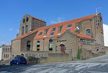
 | St Luke’s Church, Queen’s Park, Brighton St Luke’s Church is an Anglican church in the Queen’s Park area of Brighton. It was designed in the 1880s by Sir Arthur Blomfield in the Early English style. It has been given listed building status because of its architectural importance. |
 | Greek Orthodox Church of the Holy Trinity, Brighton The Church of the Holy Trinity is a Greek Orthodox church in Brighton. Built in 1838 in one of Brighton’s most notorious slum districts, Carlton Hill. It was an Anglican church for most of its life until it was declared redundant in 1980. It has been listed at Grade II since 1971. |
 | St Mary the Virgin, Brighton St Mary’s Church is an Anglican church in the Kemptown area of Brighton. The present building dates from the late 1870s and replaced a church of the same name which collapsed while being renovated. The Gothic-style red-brick building is now a Grade II* listed building. |
 | Church of the Annunciation, Brighton The Church of the Annunciation was built in the 1860s on behalf of Rev. Arthur Wagner. It served a new area of poor housing in what is now the Hanover district. The church is a Grade II listed building. |
 | Royal Crescent, Brighton Royal Crescent is a crescent-shaped terrace of houses on the seafront in Brighton, part of the English city of Brighton and Hove. Built in the late 18th and early 19th century as a speculative development on the open cliffs east of Brighton by a wealthy merchant. English Heritage has listed the crescent at Grade II* for its architectural and historical importance. |
 | Waste House Waste House is a building on the University of Brighton campus in the centre of Brighton on the south coast of England. It was built between 2012 and 2014 as a project involving hundreds of students and apprentices. The materials consist of a wide range of construction industry and household waste. It is the first public building in Europe to be built primarily of such products. |
 | St Wilfrid’s Church, Brighton St Wilfrid’s Church is a former Anglican church in the Elm Grove area of Brighton, part of the English city of Brighton and Hove. It was declared redundant after less than 50 years as a place of worship, and was converted into sheltered housing with minimal alteration to the exterior. |
 | Dorset Gardens Methodist Church Dorset Gardens Methodist Church is the third Methodist place of worship on the site. It replaced an older, larger church which was in turn a rebuilding of Brighton’s first Methodist church. Between them, the churches have played an important part in the history of Methodism in Brighton. |
 | The Blind Tiger Club, Brighton The Blind Tiger Club was a mixed music, arts and community venue in Brighton, England, which opened in 2010. Time Out described the venue as “semi-legendary”, in its round-up of Brighton’s live music scene that year. Gigwise included the club in their list of the UK’s Greatest Lost Venues. |
 | St Joseph’s Church, Brighton St Joseph’s Church is a Roman Catholic church in the Elm Grove area of Brighton, part of the English city of Brighton and Hove. It is one of eleven Roman Catholic churches in the city. The church was built in several stages, and outstanding debts meant that its official dedication took place in 1979. |
Visit Prestonville, Brighton plaques
 154
154
plaques
here Prestonville, Brighton has 154 physical plaques in tourist plaque schemes for you to explore via Walkfo Prestonville, Brighton plaques audio map when visiting. Plaques like National Heritage’s “Blue Plaques” provide visual geo-markers to highlight points-of-interest at the places where they happened – and Walkfo’s AI has researched additional, deeper content when you visit Prestonville, Brighton using the app. Experience the history of a location when Walkfo local tourist guide app triggers audio close to each Prestonville, Brighton plaque. Explore Plaques & History has a complete list of Hartlepool’s plaques & Hartlepool history plaque map.


 Trying to encourage visitors to Prestonville, Brighton?