Welcome to Visit Prestonpans Places
The Walkfo guide to things to do & explore in Prestonpans
 Visit Prestonpans places using Walkfo for free guided tours of the best Prestonpans places to visit. A unique way to experience Prestonpans’s places, Walkfo allows you to explore Prestonpans as you would a museum or art gallery with audio guides.
Visiting Prestonpans Walkfo Preview
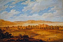
Prestonpans is located eight miles east of Edinburgh, Scotland. It is located in the unitary council area of East Lothian. The town was established in the eleventh century. Preston Tower and Mercat Cross are the only one of its kind in Scotland that remains in its original form. When you visit Prestonpans, Walkfo brings Prestonpans places to life as you travel by foot, bike, bus or car with a mobile phone & headphones.
Prestonpans Places Overview: History, Culture & Facts about Prestonpans
Visit Prestonpans – Walkfo’s stats for the places to visit
With 29 audio plaques & Prestonpans places for you to explore in the Prestonpans area, Walkfo is the world’s largest heritage & history digital plaque provider. The AI continually learns & refines facts about the best Prestonpans places to visit from travel & tourism authorities (like Wikipedia), converting history into an interactive audio experience.
Prestonpans history

According to certain stories Prestonpans was founded in the 11th century by a traveller named Althamer. The monks of Newbattle and Holyrood arrived in the district in 1184 and gave the settlement their own name, Prieststown or Prieston. Because of the salt manufacturing carried out by the monks using pans on the seashore, the town’s name would later develop into Salt Prieststown and Salt Preston.
Industry
Salt panning was a very important industry in Prestonpans. The discovery and mining of coal by the Newbattle monks in the early thirteenth century was arguably the first instance of coal mining in Britain. There was a soap works in the town which at one time had an output of 90,000 pounds (41,000 kg) per annum.
Battle of Prestonpans; Heritage Trust

Battle of Prestonpans was the first significant conflict in the second Jacobite Rising. The Jacobite army loyal to James Francis Edward Stuart defeated the Hanoverian George II led by Sir John Cope. The victory was a huge morale boost for the Jacobites, and a greatly mythologised version of the story entered art and legend. A memorial in the parish church commemorates “John Stuart of Phisgul…barbarously murdered”
Battlefield Archaeology
The site of the main battlefield is readily located today, fixed by such surviving features as the tramway embankment. Interim findings in April 2010 indicate that the true site of Highlanders’ charge is 500 yards to the east of the accepted location. The battlefield has been inventoried and protected by Historic Scotland under the Scottish Historical Environment Policy of 2009.
Prestonpans Tapestry
The Prestonpans Tapestry was unveiled on 26 July 2010. With 105 panels (each 1m long), it is about 100 ft (30m) longer than its inspiration. Inspired by Gordon Baron Prestoungrange, designed by local artist Andrew Crummy.
Why visit Prestonpans with Walkfo Travel Guide App?
 You can visit Prestonpans places with Walkfo Prestonpans to hear history at Prestonpans’s places whilst walking around using the free digital tour app. Walkfo Prestonpans has 29 places to visit in our interactive Prestonpans map, with amazing history, culture & travel facts you can explore the same way you would at a museum or art gallery with information audio headset. With Walkfo, you can travel by foot, bike or bus throughout Prestonpans, being in the moment, without digital distraction or limits to a specific walking route. Our historic audio walks, National Trust interactive audio experiences, digital tour guides for English Heritage locations are available at Prestonpans places, with a AI tour guide to help you get the best from a visit to Prestonpans & the surrounding areas.
“Curated content for millions of locations across the UK, with 29 audio facts unique to Prestonpans places in an interactive Prestonpans map you can explore.”
Walkfo: Visit Prestonpans Places Map
29 tourist, history, culture & geography spots
Prestonpans historic spots | Prestonpans tourist destinations | Prestonpans plaques | Prestonpans geographic features |
| Walkfo Prestonpans tourism map key: places to see & visit like National Trust sites, Blue Plaques, English Heritage locations & top tourist destinations in Prestonpans | |||
Best Prestonpans places to visit
Prestonpans has places to explore by foot, bike or bus. Below are a selection of the varied Prestonpans’s destinations you can visit with additional content available at the Walkfo Prestonpans’s information audio spots:
 | Cockenzie power station Cockenzie power station was a coal-fired power station in East Lothian, Scotland. It was situated on the south shore of the Firth of Forth, near the town of Cockenzie and Port Seton, 8 mi (13 km) east of Edinburgh. The station dominated the local coastline with its distinctive twin chimneys from 1967 until the chimneys’ demolition in September 2015. |
 | Seton Castle Seton Castle is an 18th-century Georgian castle in East Lothian, Scotland. The castle was Robert Adam’s final project in Scotland. |
 | Seton Palace Seton Palace was situated in East Lothian, a few miles south-east of Edinburgh. The palace was erected in the 15th century by George, 4th Lord Seton. It was a popular retreat for Mary, Queen of Scots, who spent honeymoon there in 1565. |
 | Seton Mains Halt railway station Seton Mains Halt was a railway halt of the North British Railway. It was located opposite Seton Gardens/Entrance to Seton Castle. The signal box and halt have been demolished. |
 | Prestongrange Parish Church Prestongrange Parish Church is a Church of Scotland kirk situated in the small, former mining town of Prestonpans in East Lothian. The church was built in 1596, one of the first churches to be built in Scotland following the Scottish Reformation in 1560. In 1606, the town was created a parish in its own right following centuries of being part of the parish of Tranent. |
 | Preston Tower, East Lothian Preston Tower is a ruined L-plan keep in the ancient Scottish village of Prestonpans. It is situated within a few metres of two other historic houses, Hamilton House and Northfield House. |
 | Northfield House, East Lothian Northfield House is a seventeenth-century historic house at Preston, East Lothian, Scotland. It is situated very close to Hamilton House and Preston Tower, and one mile east to Prestongrange House and the Royal Musselburgh Golf Club. |
 | Tranent Parish Church Tranent Parish Church is a kirk belonging to the Church of Scotland. It is situated in the East Lothian town of Tranent 10 miles (16 km) south-east of Edinburgh. |
 | Tranent Tower Tranent Tower is a ruined L-plan tower house dating from the 16th century. The remains are protected as a scheduled monument. |
 | Prestongrange House Prestongrange House is situated near to two other historic houses, Hamilton House and Northfield House. The house is set in a thickly wooded park and is in the Scottish baronial style. It is now the site of Royal Musselburgh Golf Club. |
Visit Prestonpans plaques
 0
0
plaques
here Prestonpans has 0 physical plaques in tourist plaque schemes for you to explore via Walkfo Prestonpans plaques audio map when visiting. Plaques like National Heritage’s “Blue Plaques” provide visual geo-markers to highlight points-of-interest at the places where they happened – and Walkfo’s AI has researched additional, deeper content when you visit Prestonpans using the app. Experience the history of a location when Walkfo local tourist guide app triggers audio close to each Prestonpans plaque. Currently No Physical Plaques.


 Trying to encourage visitors to Prestonpans?