Welcome to Visit Preston, Lancashire Places
The Walkfo guide to things to do & explore in Preston, Lancashire
 Visit Preston, Lancashire places using Walkfo for free guided tours of the best Preston, Lancashire places to visit. A unique way to experience Preston, Lancashire’s places, Walkfo allows you to explore Preston, Lancashire as you would a museum or art gallery with audio guides.
Visiting Preston, Lancashire Walkfo Preview
When you visit Preston, Lancashire, Walkfo brings Preston, Lancashire places to life as you travel by foot, bike, bus or car with a mobile phone & headphones.
Preston, Lancashire Places Overview: History, Culture & Facts about Preston, Lancashire
Visit Preston, Lancashire – Walkfo’s stats for the places to visit
With 105 audio plaques & Preston, Lancashire places for you to explore in the Preston, Lancashire area, Walkfo is the world’s largest heritage & history digital plaque provider. The AI continually learns & refines facts about the best Preston, Lancashire places to visit from travel & tourism authorities (like Wikipedia), converting history into an interactive audio experience.
Preston, Lancashire history
Early development
During the Roman period, Roman roads passed close to what is now the centre of Preston . For example, the road from Luguvalium to Mamucium crossed the River Ribble at Walton-le-Dale . At Withy Trees, 1+1/2 miles (2 km) north of Preston, a Roman camp or station may have been here .
Guild Merchant

The right to hold a Guild Merchant was conferred by King Henry II upon the burgesses of Preston in a charter of 1179 . The associated Preston Guild is a civic celebration held every 20 years and 2012 was the latest guild year . It is the only guild still celebrated in the UK .
Pre-industrial Preston

In the mid-12th century, Preston was in the hundred of Amounderness . The name “Amounderness” is more ancient than any other “Wapentake” or hundred in Lancashire .
Industrial revolution
The 19th century saw a transformation in Preston from a small market town to a much larger industrial one . With industrialisation came examples of both oppression and enlightenment .
Preston since the early 20th century

By 1901, nearly 120,000 people were living in Preston, now a booming industrial town . Preston is now a thriving industrial town with a population of nearly 100,000 .
Preston, Lancashire economy & business
Major employers
BAE Systems is the UK’s principal military aircraft design, development and manufacture supplier . The company has two of its major facilities located some miles on either side of the city .
Education and research
The University of Central Lancashire has become a major employer and source of economic growth in recent years . It provides direct and indirect benefits to the local economy through employment, housing and retail .
Proposed developments
An £800 million regeneration project known as the Tithebarn Project was also planned for Preston . The project was originally managed by property giants Grosvenor and Lendlease . In November 2011, it was announced that John Lewis, who were originally intended to be the major flagship store, had also withdrawn from the project .
Preston, Lancashire toponymy
Preston was recorded in the Domesday Book of 1086 as Prestune. The town’s name is derived from the Old English words Presta and tun. The tun (enclosure, farmstead, village, manor, estate) of the Presta is the name of the town.
Preston, Lancashire landmarks

St Walburge’s Church, designed by Joseph Hansom of Hansom Cab fame, has the tallest spire in England on a church that is not a cathedral and the third tallest in the UK. HMP Preston is also a good example of a typical Victorian radial-design prison. Modern architecture is represented by the Guild Hall and Preston bus station.
Listed buildings
The Grade II listed Tulketh Mill dates from 1905 and dates back to 1905 . The huge chimney has been lowered twice – in the 1930s and again in the 1960s .
Monuments and public artworks
Preston has a number of notable monuments and public artworks, including: Preston . Preston is the birthplace of Preston, England, and the site of the first railway station . Preston was the first station on the Underground Underground Railroad to open a railway station in 1903 .
Preston, Lancashire geography / climate
The Forest of Bowland forms a backdrop to Preston to the northeast. The River Ribble provides a southern border for the city. Preston is approximately 27 miles (43 km) north west of Manchester. The Fylde lies to the west of Preston.
Climate
The climate of Preston is of a temperate maritime type, with a narrow range of temperatures . Being relatively close to the Irish sea, this is more pronounced than areas to the south and east of Preston . The official Met Office weather station is located at Moor Park, north of the city centre .
Why visit Preston, Lancashire with Walkfo Travel Guide App?
 You can visit Preston, Lancashire places with Walkfo Preston, Lancashire to hear history at Preston, Lancashire’s places whilst walking around using the free digital tour app. Walkfo Preston, Lancashire has 105 places to visit in our interactive Preston, Lancashire map, with amazing history, culture & travel facts you can explore the same way you would at a museum or art gallery with information audio headset. With Walkfo, you can travel by foot, bike or bus throughout Preston, Lancashire, being in the moment, without digital distraction or limits to a specific walking route. Our historic audio walks, National Trust interactive audio experiences, digital tour guides for English Heritage locations are available at Preston, Lancashire places, with a AI tour guide to help you get the best from a visit to Preston, Lancashire & the surrounding areas.
“Curated content for millions of locations across the UK, with 105 audio facts unique to Preston, Lancashire places in an interactive Preston, Lancashire map you can explore.”
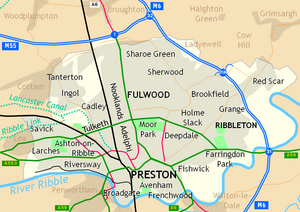
Walkfo: Visit Preston, Lancashire Places Map
105 tourist, history, culture & geography spots
Preston, Lancashire historic spots | Preston, Lancashire tourist destinations | Preston, Lancashire plaques | Preston, Lancashire geographic features |
| Walkfo Preston, Lancashire tourism map key: places to see & visit like National Trust sites, Blue Plaques, English Heritage locations & top tourist destinations in Preston, Lancashire | |||
Best Preston, Lancashire places to visit
Preston, Lancashire has places to explore by foot, bike or bus. Below are a selection of the varied Preston, Lancashire’s destinations you can visit with additional content available at the Walkfo Preston, Lancashire’s information audio spots:
 | Winckley Square Winckley Square is situated near the centre of Preston, Lancashire . It is situated at the west end of Avenham at the end of the Avenham Road . |
 | Fishergate Shopping Centre Fishergate Shopping Centre is a shopping centre in the city of Preston in Lancashire . Fishergate shopping centre is located in Fishergate, Preston . |
 | The Guild, Preston The Guild is a grade II listed public house at 99 Fylde Road in Preston, Lancashire . It was built as the home of cotton manufacturer William Taylor and became a pub in the late 1980s . |
 | Cuerdale Hoard The Cuerdale Hoard is a hoard of more than 8,600 items, including silver coins, English and Carolingian jewellery, hacksilver and ingots . It was discovered on 15 May 1840 on the southern bank of a bend of the River Ribble in Lancashire . |
 | Ribbleton Ribbleton is a suburb and ward of Preston, Lancashire. It is located to the east of the city centre, between the A59 New Hall Lane and the B6243 Longridge Road. The ward had a population of 7,351 recorded in the 2001 census. |
 | St Andrew’s Church, Ashton-on-Ribble St Andrew’s Church is in Blackpool Road, Ashton-on-Ribble, Preston, Lancashire. It is an active Anglican parish church in the deanery of Preston, the archdeaconry of Lancaster, and the diocese of Blackburn. The church is recorded in the National Heritage List for England as a designated Grade II listed building. |
 | Ribble Steam Railway The Ribble Steam Railway is a standard gauge preserved railway in Lancashire. It was opened to the public on 17 September 2005, running along Preston Docks. The railway began by housing much of the collection from the previously closed Southport Railway Museum. |
Visit Preston, Lancashire plaques
 20
20
plaques
here Preston, Lancashire has 20 physical plaques in tourist plaque schemes for you to explore via Walkfo Preston, Lancashire plaques audio map when visiting. Plaques like National Heritage’s “Blue Plaques” provide visual geo-markers to highlight points-of-interest at the places where they happened – and Walkfo’s AI has researched additional, deeper content when you visit Preston, Lancashire using the app. Experience the history of a location when Walkfo local tourist guide app triggers audio close to each Preston, Lancashire plaque. Explore Plaques & History has a complete list of Hartlepool’s plaques & Hartlepool history plaque map.


 Trying to encourage visitors to Preston, Lancashire?