Welcome to Visit Poulton-le-Fylde Places
The Walkfo guide to things to do & explore in Poulton-le-Fylde
 Visit Poulton-le-Fylde places using Walkfo for free guided tours of the best Poulton-le-Fylde places to visit. A unique way to experience Poulton-le-Fylde’s places, Walkfo allows you to explore Poulton-le-Fylde as you would a museum or art gallery with audio guides.
Visiting Poulton-le-Fylde Walkfo Preview
Poulton-le-Fylde is situated on the coastal plain called the Fylde. In the 2001 United Kingdom census, it had a population of 18,264. Evidence of human habitation in the area from 12,000 years ago. When you visit Poulton-le-Fylde, Walkfo brings Poulton-le-Fylde places to life as you travel by foot, bike, bus or car with a mobile phone & headphones.
Poulton-le-Fylde Places Overview: History, Culture & Facts about Poulton-le-Fylde
Visit Poulton-le-Fylde – Walkfo’s stats for the places to visit
With 44 audio plaques & Poulton-le-Fylde places for you to explore in the Poulton-le-Fylde area, Walkfo is the world’s largest heritage & history digital plaque provider. The AI continually learns & refines facts about the best Poulton-le-Fylde places to visit from travel & tourism authorities (like Wikipedia), converting history into an interactive audio experience.
Poulton-le-Fylde history
Early history
There is evidence of human habitation in the area around Poulton from c. 10,000 BC. In 1970, building work in nearby Carleton uncovered the 12,000-year-old skeleton of an elk, along with two bone or antler barbed points close to its hind bones. At the time of the Roman conquest of Britain in the 1st century AD, the area was inhabited by a Celtic tribe called the Setantii. A 4th century hoard of 400 Roman coins was found in the area, near Fleetwood. Other finds have been made in Poulton and Skippool; in addition to coins, these have included a medal of Germanicus and a hipposandal (similar to a horseshoe). Although there is little archaeological evidence of Anglo-Saxon activity in the area following the departure of the Romans, local place names incorporate Old English elements like tūn (farmstead), suggesting that they were founded in that period. Nearby examples are Thornton, Marton and Carleton. Poulton was recorded in 1086 as Poltun; the name is derived from the Old English words pull or pōl + tūn meaning “farmstead by a pool or creek”. In later years, it was recorded variously as Pultun, Polton, Potton, Poolton and Poulton. The affix le-Fylde (“in the district called the Fylde”) was added in 1842 with the arrival of the Penny Post, to distinguish the town from Poulton-le-Sands, a village that is now part of Morecambe. Poulton is one of seven ancient parishes of the hundred of Amounderness. Prior to the Norman conquest in 1066, Amounderness was in the possession of Earl Tostig, the brother of King Harold II. Tostig died at the Battle of Stamford Bridge and his lands were subsequently taken over by the Normans. Between 1069 and 1086 William the Conqueror gave Amounderness to Anglo-Norman Baron Roger the Poitevin. In the Domesday Book of 1086 Poulton’s area was estimated to contain two carucates of arable land. The survey recorded three churches in Amounderness though not by name. Later documentary evidence suggests that they were probably the churches at Poulton, Kirkham and St Michael’s on Wyre. The dedication of Poulton’s church to 7th century Anglo-Saxon saint Chad of Mercia lends weight to its pre-conquest foundation, although it is possible that it was built between 1086 and 1094. In 1094, Roger the Poitevin founded the Benedictine priory of St. Mary at Lancaster, as a cell of the Norman Abbey of St. Martin in Sées. He endowed the priory with the church and land at Poulton. Roger was eventually banished from the country and his lands returned to the possession of the Crown. In 1194 King Richard I granted the hundred of Amounderness to Theobald Walter, 1st Baron Butler, who held it until his death in 1206. In 1268, King Henry III granted the wapentake of Amounderness to his son Edmund Crouchback, who became the 1st Earl of Lancaster around this time. The amount of land in Poulton owned by St. Mary’s Priory increased during the 12th and 13th centuries and caused conflict with local landowners over whose land the tenants and monks of the priory had to cross. In 1276, Sir Adam Banastre and his supporters assaulted the prior, Ralph de Truno, as he travelled to Poulton. He and his attendants were taken by Banastre, beaten and imprisoned in Thornton. An investigation into the incident was instigated by the king; no record survives. In 1330, a compromise was made when two roads were built through Banastre’s land which enabled the prior and his tenants to travel freely to Poulton. During the 13th and 14th centuries, much of the land at Poulton was given to Cockersand Abbey in Lancaster and rented back to local farm workers. Much of the land in the Fylde was donated either to Cockersand Abbey or Whalley Abbey. To efficiently manage and farm these lands, granges were built at Singleton and Staining. When the alien priories (those under control of religious houses abroad) were dissolved in 1415, the church at Poulton was conveyed to the Abbey of Syon in Middlesex. In the 17th century Civil Wars, townspeople of Poulton fought on both sides, although more men from the Fylde were on the side of the Royalists. No battles occurred in or close to Poulton but the area was affected with the rest of the county by the widespread poverty that resulted from the wars. In 1643 interest was stirred in the parish when a large Spanish vessel dropped anchor off the coast at Rossall. The ship made no movement for several days but fired its guns occasionally. Locals initially feared an invasion, but eventually realised that the crew was in distress and had been signalling for help. The vessel was carrying ammunition for the Parliamentarian forces and the crew had become sick and feeble. The ship was brought by Royalists into the mouth of the River Wyre and the Earl of Derby marched from across the River Ribble. He ordered the ship to be burnt and the Spanish crew to be set free. The port of Poulton played a role in the Atlantic slave trade during the 18th century, with at least four slaving voyages setting off from Poulton between 1753 and 1757. In the 18th century it was the custom for the wealthy in Poulton to bury their dead at night, following a lamp-lit procession through town. This tradition lasted until 1810. In 1732, during the procession preceding the funeral of Geoffrey Hornby, strong winds caused sparks to fly from the lighted tapers carried by mourners. The buildings on the west side of the market place, low cottages with thatched roofs, caught fire and were destroyed. After local fund-raising the houses were eventually replaced with brick buildings with tile roofs.
19th and 20th centuries
Poulton became an important centre for trade in the Fylde with harbours on either side of the River Wyre. With harbours at Skippool and Wardleys, it was able to import goods from as far away as Russia and North America. In the early part of the 19th century, there was a significant decline in the craft industries because of increased mechanisation.
Poulton-le-Fylde landmarks

Poulton town centre has been a Conservation Area since 1979. 15 buildings and structures in the town have been designated as listed buildings by English Heritage for their special architectural, historical or cultural significance. The market place is the width of two streets and is now closed to motor traffic.
Poulton-le-Fylde geography / climate

Poulton-le-Fylde is situated on the Fylde, a coastal plain that is approximately a 13-mile (20 km) square peninsula. The bedrock of the area consists of Permo-Triassic sandstones and particularly Triassic mudstones. Until the 20th century, the town consisted of only a few streets surrounding the central market place.
Why visit Poulton-le-Fylde with Walkfo Travel Guide App?
 You can visit Poulton-le-Fylde places with Walkfo Poulton-le-Fylde to hear history at Poulton-le-Fylde’s places whilst walking around using the free digital tour app. Walkfo Poulton-le-Fylde has 44 places to visit in our interactive Poulton-le-Fylde map, with amazing history, culture & travel facts you can explore the same way you would at a museum or art gallery with information audio headset. With Walkfo, you can travel by foot, bike or bus throughout Poulton-le-Fylde, being in the moment, without digital distraction or limits to a specific walking route. Our historic audio walks, National Trust interactive audio experiences, digital tour guides for English Heritage locations are available at Poulton-le-Fylde places, with a AI tour guide to help you get the best from a visit to Poulton-le-Fylde & the surrounding areas.
“Curated content for millions of locations across the UK, with 44 audio facts unique to Poulton-le-Fylde places in an interactive Poulton-le-Fylde map you can explore.”
Walkfo: Visit Poulton-le-Fylde Places Map
44 tourist, history, culture & geography spots
Poulton-le-Fylde historic spots | Poulton-le-Fylde tourist destinations | Poulton-le-Fylde plaques | Poulton-le-Fylde geographic features |
| Walkfo Poulton-le-Fylde tourism map key: places to see & visit like National Trust sites, Blue Plaques, English Heritage locations & top tourist destinations in Poulton-le-Fylde | |||
Best Poulton-le-Fylde places to visit
Poulton-le-Fylde has places to explore by foot, bike or bus. Below are a selection of the varied Poulton-le-Fylde’s destinations you can visit with additional content available at the Walkfo Poulton-le-Fylde’s information audio spots:

Blackpool Victoria Hospital
Blackpool Victoria Hospital, known locally as “The Vic”, is the main hospital for Blackpool and the Fylde Coast. The hospital is managed by the Blackpool Teaching Hospitals NHS Foundation Trust.

Kingscote Park, Blackpool
Kingscote Park is a municipal park extending over 98 acres (40 ha; 0.40 km) in Layton, a suburb of Blackpool in the county of Lancashire. The park is the second largest park within Blackpool after Stanley Park.

St Mark’s Church, Blackpool
The Parish Church of St. Mark, Layton, Lancashire, England was built in 1927. The building is home to a Church of England Christian community. Layton Village was mentioned in the Norman Era 1066-1154 AD.

Layton, Blackpool
Layton is a district and electoral ward of the town of Blackpool in England. The ward population at the 2011 census was 6,845.

Layton cemetery
Layton cemetery is a graveyard located at Talbot Road in Blackpool, Lancashire. It was opened in 1873 when Blackpool parish church was replete with burying. Originally there were three mortuary chapels, Anglican, Catholic and Non-Conformist but only the Anglican remains. A World War I memorial is centrally situated.

Carleton Crematorium and Cemetery
Carleton Crematorium, together with the adjacent necropolis, Carleton Cemetery, is a graveyard located within the Greenlands ward of Blackpool. The building was created by Blackpool Borough architect, J.C. Robinson, who based his design on his interpretation of the Mausoleum of Mausolus.

Moor Park, Blackpool
Moor Park is a municipal park located in the Moor Park area of Bispham in Blackpool on the Fylde coast in Lancashire. It is opposite Moor Park Primary School and Boiks onion sauce factory which opened in 2021.
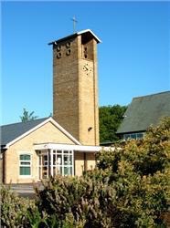
Christ Church, Thornton
Christ Church is in Meadows Avenue, Thornton, Lancashire, England. It is an active Anglican parish church in the deanery of Poulton, the archdeaconry of Lancaster, and the diocese of Blackburn.

Bispham Parish Church
Bispham Parish Church, also known as All Hallows Church, is a Grade II Listed Building. It is the third church on the site and was built in 1883. Until 1821 the parish church was the only place of worship in Blackpool.

The Illawalla
The Illawalla was an Edwardian single-story building in the Skippool area of Thornton, Lancashire. Built in 1902, it was demolished in 1996, after lying derelict for six years, to make way for three exclusive homes.
Visit Poulton-le-Fylde plaques
 1
1
plaques
here Poulton-le-Fylde has 1 physical plaques in tourist plaque schemes for you to explore via Walkfo Poulton-le-Fylde plaques audio map when visiting. Plaques like National Heritage’s “Blue Plaques” provide visual geo-markers to highlight points-of-interest at the places where they happened – and Walkfo’s AI has researched additional, deeper content when you visit Poulton-le-Fylde using the app. Experience the history of a location when Walkfo local tourist guide app triggers audio close to each Poulton-le-Fylde plaque. Explore Plaques & History has a complete list of Hartlepool’s plaques & Hartlepool history plaque map.


 Trying to encourage visitors to Poulton-le-Fylde?