Welcome to Visit Plenmeller Places
The Walkfo guide to things to do & explore in Plenmeller
 Visit Plenmeller places using Walkfo for free guided tours of the best Plenmeller places to visit. A unique way to experience Plenmeller’s places, Walkfo allows you to explore Plenmeller as you would a museum or art gallery with audio guides.
Visiting Plenmeller Walkfo Preview
Plenmeller is a village in Northumberland, England. It is about a mile (1½ km) southeast of Haltwhistle. When you visit Plenmeller, Walkfo brings Plenmeller places to life as you travel by foot, bike, bus or car with a mobile phone & headphones.
Plenmeller Places Overview: History, Culture & Facts about Plenmeller
Visit Plenmeller – Walkfo’s stats for the places to visit
With 16 audio plaques & Plenmeller places for you to explore in the Plenmeller area, Walkfo is the world’s largest heritage & history digital plaque provider. The AI continually learns & refines facts about the best Plenmeller places to visit from travel & tourism authorities (like Wikipedia), converting history into an interactive audio experience.
Plenmeller etymology
It is generally agreed that the name “Plenmeller” is of Brythonic Celtic origin. The first element is most plausibly blajn meaning “summit” Suffixes of -maɣl, “chief” and -mę:l are both possible.
Plenmeller landmarks
Unthank Hall is a Grade II listed mansion house situated on the southern bank of the River South Tyne. The house was built in the 16th century, incorporating an ancient Pele tower. It was substantially remodelled and extended in 1815 and rebuilt in 1862.
Why visit Plenmeller with Walkfo Travel Guide App?
 You can visit Plenmeller places with Walkfo Plenmeller to hear history at Plenmeller’s places whilst walking around using the free digital tour app. Walkfo Plenmeller has 16 places to visit in our interactive Plenmeller map, with amazing history, culture & travel facts you can explore the same way you would at a museum or art gallery with information audio headset. With Walkfo, you can travel by foot, bike or bus throughout Plenmeller, being in the moment, without digital distraction or limits to a specific walking route. Our historic audio walks, National Trust interactive audio experiences, digital tour guides for English Heritage locations are available at Plenmeller places, with a AI tour guide to help you get the best from a visit to Plenmeller & the surrounding areas.
“Curated content for millions of locations across the UK, with 16 audio facts unique to Plenmeller places in an interactive Plenmeller map you can explore.”
Walkfo: Visit Plenmeller Places Map
16 tourist, history, culture & geography spots
Plenmeller historic spots | Plenmeller tourist destinations | Plenmeller plaques | Plenmeller geographic features |
| Walkfo Plenmeller tourism map key: places to see & visit like National Trust sites, Blue Plaques, English Heritage locations & top tourist destinations in Plenmeller | |||
Best Plenmeller places to visit
Plenmeller has places to explore by foot, bike or bus. Below are a selection of the varied Plenmeller’s destinations you can visit with additional content available at the Walkfo Plenmeller’s information audio spots:
 | Haltwhistle War Memorial Hospital Haltwhistle War Memorial Hospital is a health facility at Greencroft Park, Northumberland. It is managed by Northumbria Healthcare NHS Foundation Trust. The war memorial itself is a Grade II listed structure. |
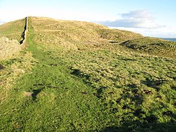
 | Haltwhistle Burn The Haltwhistle Burn is a river which lies to the east of the Northumbrian town of Northumbria. The burn passes through the Roman Military Zone south of Hadrian’s Wall and through a dramatic sandstone gorge before descending between wooded banks to the South Tyne Valley. |
 | Burnfoot River Shingle and Wydon Nabb Burnfoot River Shingle and Wydon Nabb is a Site of Special Scientific Interest (SSSI) in Northumberland, North East England. It is a calaminarian grassland on the River South Tyne where the local flora is influenced by high levels of naturally occurring heavy metals. |
 | Milecastle 43 Milecastle 43 (Great Chesters) was a milecastle on Hadrian’s Wall. It was obliterated when the fort at Great Chesters (Aesica) was built. |
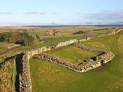 | Milecastle 42 Milecastle 42 (Cawfields) is a milecastle on Hadrian’s Wall (grid reference NY7157466692) It is located in Cawfields, Cawfield. |
 | Milecastle 41 Milecastle 41 (Melkridge) was a milecastle on Hadrian’s Wall (grid reference NY73026705) Milecastle was located in Melkridge, New York. |
Visit Plenmeller plaques
 2
2
plaques
here Plenmeller has 2 physical plaques in tourist plaque schemes for you to explore via Walkfo Plenmeller plaques audio map when visiting. Plaques like National Heritage’s “Blue Plaques” provide visual geo-markers to highlight points-of-interest at the places where they happened – and Walkfo’s AI has researched additional, deeper content when you visit Plenmeller using the app. Experience the history of a location when Walkfo local tourist guide app triggers audio close to each Plenmeller plaque. Explore Plaques & History has a complete list of Hartlepool’s plaques & Hartlepool history plaque map.


 Trying to encourage visitors to Plenmeller?