Welcome to Visit Plas Coch Places
The Walkfo guide to things to do & explore in Plas Coch
 Visit Plas Coch places using Walkfo for free guided tours of the best Plas Coch places to visit. A unique way to experience Plas Coch’s places, Walkfo allows you to explore Plas Coch as you would a museum or art gallery with audio guides.
Visiting Plas Coch Walkfo Preview
Plas Coch refers to an unofficial area of Rhosddu, Wrexham, north Wales. Formerly known as Lower Stansty, the term has fallen out of use in recent years. When you visit Plas Coch, Walkfo brings Plas Coch places to life as you travel by foot, bike, bus or car with a mobile phone & headphones.
Plas Coch Places Overview: History, Culture & Facts about Plas Coch
Visit Plas Coch – Walkfo’s stats for the places to visit
With 72 audio plaques & Plas Coch places for you to explore in the Plas Coch area, Walkfo is the world’s largest heritage & history digital plaque provider. The AI continually learns & refines facts about the best Plas Coch places to visit from travel & tourism authorities (like Wikipedia), converting history into an interactive audio experience.
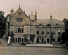
Plas Coch history
Plas Coch was built in the late 16th century of mature hand-made red brick, hence the name “Plas Coch” The house was built for Sir William Meredith, one of the sons of Richard Meredith of Allington or Trevalyn (near Rossett) and treasurer and paymaster of the army in the reigns of Elizabeth I and James I. Sadly the house and outbuildings were demolished in the 1980s to make way for a large supermarket and retail development.
Plas Coch geography / climate
The borders of Plas Coch are loosely defined, but the area is regarded to be centred on Pla Coch Road, located between Stansty Road to the north, and Mold Road (A541) to the south. The retail park on Berse Road in the community of Offa, home to DIY stores such as B&Q, is sometimes regarded as part of the area.
Why visit Plas Coch with Walkfo Travel Guide App?
 You can visit Plas Coch places with Walkfo Plas Coch to hear history at Plas Coch’s places whilst walking around using the free digital tour app. Walkfo Plas Coch has 72 places to visit in our interactive Plas Coch map, with amazing history, culture & travel facts you can explore the same way you would at a museum or art gallery with information audio headset. With Walkfo, you can travel by foot, bike or bus throughout Plas Coch, being in the moment, without digital distraction or limits to a specific walking route. Our historic audio walks, National Trust interactive audio experiences, digital tour guides for English Heritage locations are available at Plas Coch places, with a AI tour guide to help you get the best from a visit to Plas Coch & the surrounding areas.
“Curated content for millions of locations across the UK, with 72 audio facts unique to Plas Coch places in an interactive Plas Coch map you can explore.”
Walkfo: Visit Plas Coch Places Map
72 tourist, history, culture & geography spots
Plas Coch historic spots | Plas Coch tourist destinations | Plas Coch plaques | Plas Coch geographic features |
| Walkfo Plas Coch tourism map key: places to see & visit like National Trust sites, Blue Plaques, English Heritage locations & top tourist destinations in Plas Coch | |||
Best Plas Coch places to visit
Plas Coch has places to explore by foot, bike or bus. Below are a selection of the varied Plas Coch’s destinations you can visit with additional content available at the Walkfo Plas Coch’s information audio spots:
 | Borras Park Borras Park (Welsh: Parc Borras / Parc Bwras) is an electoral division in the community of Acton in Wrexham County Borough, Wales. The name is derived from the nearby area of Borras. At the time of the 2001 Census, the population was 2,517 in 1,065 household, reducing to 2,359 at the 2011 Census. |
 | Ysgol Morgan Llwyd Ysgol Morgan Llwyd is a Welsh-medium comprehensive school in Wrexham, north-east Wales. It is named after the seventeenth century preacher and author Morgan Lillwyd. The school has been open at its present location in Cefn Road since 2000. |
 | Caia Park Caia Park (Welsh: Parc Caia) is a local government community in Wrexham County Borough, Wales. It was created in 1985 after a boundary commission review of the four community areas within the town of Wrexham, the others being Acton, Offa, and Rhosddu. At the 2001 census, the community had a population of 11,882 in 5,019 households, increasing to 12,602 in 2011. |
 | Brymbo Hall Brymbo Hall is one of Britain’s lost houses. It was the residence of industrialist and ironmaster John “Iron-Mad” Wilkinson. It is reputed to have been partly built to the designs of Inigo Jones. |
 | Wrexham-Rhos transmitting station The Wrexham-Rhos transmitting station is a digital television relay of Moel-y-Parc. It is a free-standing lattice tower structure serving around 85,000 homes. It was constructed to coincide with the 1977 National Eisteddfod. It initially provided S4C and BBC One Wales, later joined by HTV Wales in 1997. |
 | Rhosddu Rhosddu (Welsh pronunciation) is a local government community in Wrexham County Borough, Wales. At the 2011 Census, the population of the community was 6,840 and 11.8% of people aged 3+ spoke Welsh. |
 | Wrexham General railway station Wrexham General is the main railway station in north-east Wales. The station was first opened in 1846 and expanded in 1912. It is currently operated by Transport for Wales, but services are also provided by Avanti West Coast. |
 | Wrexham County Borough Wrexham County Borough is a principal area with county borough status in the preserved county of Clwyd, Wales. The county borough was formed on 1 April 1996 and has a population of nearly 135,000 inhabitants. The area has strong links with coal-mining and has only two urban towns, Chirk and Holt. |
 | Llwyn Isaf Llwyn Isaf (“lower grove”) is a green space in the centre of Wrexham. It is surrounded on two sides by the town’s guildhall and on another by the Library Arts Centre. The space is most popular with students from Yale College. |
 | Gresford Colliery Gresford Colliery was a coal mine located a mile from the North Wales village of Greffford, near Wrexham. The mine was a one-mile-long mine located near the village of Gresford. |
Visit Plas Coch plaques
 0
0
plaques
here Plas Coch has 0 physical plaques in tourist plaque schemes for you to explore via Walkfo Plas Coch plaques audio map when visiting. Plaques like National Heritage’s “Blue Plaques” provide visual geo-markers to highlight points-of-interest at the places where they happened – and Walkfo’s AI has researched additional, deeper content when you visit Plas Coch using the app. Experience the history of a location when Walkfo local tourist guide app triggers audio close to each Plas Coch plaque. Currently No Physical Plaques.


 Trying to encourage visitors to Plas Coch?