Welcome to Visit Peterborough Places
The Walkfo guide to things to do & explore in Peterborough
 Visit Peterborough places using Walkfo for free guided tours of the best Peterborough places to visit. A unique way to experience Peterborough’s places, Walkfo allows you to explore Peterborough as you would a museum or art gallery with audio guides.
Visiting Peterborough Walkfo Preview
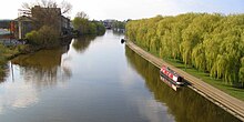
Peterborough is a cathedral city and unitary authority area in Cambridgeshire . The city is 76 mi (122 km) north of London, on the River Nene which flows into the North Sea 30 mi (48 km) to the north-east . The railway station is an important stop on the East Coast Main Line between London and Edinburgh . When you visit Peterborough, Walkfo brings Peterborough places to life as you travel by foot, bike, bus or car with a mobile phone & headphones.
Peterborough Places Overview: History, Culture & Facts about Peterborough
Visit Peterborough – Walkfo’s stats for the places to visit
With 79 audio plaques & Peterborough places for you to explore in the Peterborough area, Walkfo is the world’s largest heritage & history digital plaque provider. The AI continually learns & refines facts about the best Peterborough places to visit from travel & tourism authorities (like Wikipedia), converting history into an interactive audio experience.
Peterborough history
The original name of the town was Medeshamstede. The town’s name changed to Burgh from the late tenth century. The contrasting form Gildenburgh is also found in the 12th century history of the abbey, the Peterborough version of the Anglo-Saxon Chronicle.
Early history
Present-day Peterborough is the latest in a series of settlements which have at one time or other benefited from its site where the Nene leaves large areas of permanently drained land for the fens. Remains of Iron Age settlement and what is thought to be religious activity can be seen at the Flag Fen archaeological site to the east of the city centre. The Romans established a fortified garrison town at Durobrivae on Ermine Street, five miles (8 km) to the west in Water Newton, around the middle of the 1st century AD. Durobrivae’s earliest appearance among surviving records is in the Antonine Itinerary of the late 2nd century. There was also a large 1st century Roman fort at Longthorpe, designed to house half a legion, or about 3,000 soldiers; it may have been established as early as around AD 44–48. Peterborough was an important area of ceramic production in the Roman period, providing Nene Valley Ware that was traded as far away as Cornwall and the Antonine Wall, Caledonia. Peterborough is shown by its original name Medeshamstede to have possibly been an Anglian settlement before AD 655, when Sexwulf founded a monastery on land granted to him for that purpose by Peada of Mercia, who converted to Christianity and was briefly ruler of the smaller Middle Angles sub-group. His brother Wulfhere murdered his own sons, similarly converted and then finished the monastery by way of atonement. Hereward the Wake rampaged through the town in 1069 or 1070. Outraged, Abbot Turold erected a fort or castle, which, from his name, was called Mont Turold: this mound, or hill, is on the outside of the deanery garden, now called Tout Hill, although in 1848 Tot-hill or Toot Hill. The abbey church was rebuilt and greatly enlarged in the 12th century. The Peterborough Chronicle, a version of the Anglo-Saxon one, contains unique information about the history of England after the Norman conquest, written here by monks in the 12th century. This is the only known prose history in English between the conquest and the later 14th century. The burgesses received their first charter from “Abbot Robert” – probably Robert of Sutton (1262–1273). The place suffered materially in the war between King John and the confederate barons, many of whom took refuge in the monastery here and in Crowland Abbey, from which sanctuaries they were forced by the king’s soldiers, who plundered the religious houses and carried off great treasures. The abbey church became one of Henry VIII’s retained, more secular, cathedrals in 1541, having been assessed at the Dissolution (in the King’s Books) as having revenue of £1,972.7s.0¾d per annum. When civil war broke out, Peterborough was divided between supporters of King Charles I and the Long Parliament. The city lay on the border of the Eastern Association of counties which sided with Parliament, and the war reached Peterborough in 1643 when soldiers arrived in the city to attack Royalist strongholds at Stamford and Crowland. The Royalist forces were defeated within a few weeks and retreated to Burghley House, where they were captured and sent to Cambridge. While the Parliamentary soldiers were in Peterborough, however, they ransacked the cathedral, destroying the Lady Chapel, chapter house, cloister, high altar and choir stalls, as well as mediaeval decoration and records. Housing and sanitary improvements were effected under the provisions of an Act of Parliament passed in 1790; and an Act was passed in 1839 to build a gaol to replace the two that previously stood. After the dissolution the dean and chapter, who succeeded the abbot as lords of the manor, appointed a high bailiff and the constables and other borough officers were elected at their court leet; but this ended when the municipal borough was incorporated in 1874 under the government of a mayor, six aldermen and eighteen councillors. Among the privileges claimed by the abbot as early as the 13th century was that of having a prison for felons taken in the Soke of Peterborough. In 1576 Bishop Edmund Scambler sold the lordship of the hundred of Nassaburgh, which was coextensive with the Soke, to Queen Elizabeth I, who gave it to Lord Burghley, and from that time until the 19th century he and his descendants, the Earls and Marquesses of Exeter, had a separate gaol for prisoners arrested in the Soke. The abbot formerly held four fairs, of which two, St. Peter’s Fair, granted in 1189 and later held on the second Tuesday and Wednesday in July, and the Brigge Fair, granted in 1439 and later held on the first Tuesday, Wednesday and Thursday in October, were purchased by the corporation from the Ecclesiastical Commissioners in 1876. The Bridge Fair, as it is now known, granted to the abbey by King Henry VI, survives. Prayers for the opening of the fair were once said at the morning service in the cathedral, followed by a civic proclamation and a sausage lunch at the town hall which still takes place. The mayor traditionally leads a procession from the town hall to the fair where the proclamation is read, asking all persons to “behave soberly and civilly, and to pay their just dues and demands according to the laws of the realm and the rights of the City of Peterborough”.
Modern history
Railway lines began operating locally during the 1840s, but it was the 1850 opening of the Great Northern Railway’s line from London to York that transformed Peterborough from a market town to an industrial centre. Lord Exeter had opposed the railway passing through Stamford, so Peterborough, situated between two main terminals at London and Doncaster, increasingly developed as a regional hub. Coupled with vast local clay deposits, the railway enabled large-scale brick-making and distribution to take place. The area was the UK’s leading producer of bricks for much of the twentieth century. Brick-making had been a small seasonal craft since the early nineteenth century, but during the 1890s successful experiments at Fletton using the harder clays from a lower level had resulted in a much more efficient process. The market dominance during this period of the London Brick Company, founded by the prolific Scottish builder and architect John Cathles Hill, gave rise to some of the country’s most well-known landmarks, all built using the ubiquitous Fletton Brick. Perkins Engines was established in Peterborough in 1932 by Frank Perkins, creator of the Perkins diesel engine. Thirty years later it employed more than a tenth of the population of Peterborough, mainly at Eastfield. Baker Perkins had relocated from London to Westwood, now the site of HM Prison Peterborough, in 1903, followed by Peter Brotherhood to Walton in 1906; both manufacturers of industrial machinery, they too became major employers in the city. British Sugar remains headquartered in Woodston, although the beet sugar factory, which opened there in 1926, was closed in 1991. The Norwich and Peterborough (N&P) was formed by the merger of the Norwich Building Society and the Peterborough Building Society in 1986. It was the ninth largest building society at the time of its merger into the Yorkshire Group in 2011. N&P continued to operate under its own brand administered at Lynch Wood until 2018. Prior to merger with the Midlands Co-op in 2013, Anglia Regional, the UK’s fifth largest co-operative society, was also based in Peterborough, where it was established in 1876. The combined society began trading as Central England Co-operative in 2014. Designated a New Town in 1967, Peterborough Development Corporation was formed in partnership with the city and county councils to house London’s overspill population in new townships sited around the existing urban area. There were to be four townships, one each at Bretton (originally to be called Milton, a hamlet in the Middle Ages), Orton, Paston/ Werrington and Castor. The last of these was never built, but a fourth, called Hampton, is now taking shape south of the city. It was decided that the city should have a major indoor shopping centre at its heart. Planning permission was received in late summer 1976 and Queensgate, containing over 90 stores and including parking for 2,300 cars, was opened by Queen Beatrix of the Netherlands in 1982. 34 miles (55 km) of urban roads were planned and a network of high-speed landscaped thoroughfares, known as parkways, was constructed. Peterborough’s population grew by 45.4% between 1971 and 1991. New service-sector companies like Thomas Cook and Pearl Assurance were attracted to the city, ending the dominance of the manufacturing industry as employers. An urban regeneration company named Opportunity Peterborough, under the chairmanship of Lord Mawhinney, was set up by the Office of the Deputy Prime Minister in 2005 to oversee Peterborough’s future development. Between 2006 and 2012 a £1 billion redevelopment of the city centre and surrounding areas was planned. The master plan provided guidelines on the physical shaping of the city centre over the next 15–20 years. Proposals are still progressing for the north of Westgate, the south bank and the station quarter, where Network Rail is preparing a major mixed use development. Whilst recognising that the reconfiguration of the relationship between the city and station was critical, English Heritage found the current plans for Westgate unconvincing and felt more thought should be given to the vitality of the historic core. With the city expanding, in July 2005 the council adopted a new statutory development plan. Its aim is to accommodate an additional 22,000 homes, 18,000 jobs and over 40,000 people living in Peterborough by 2020. The newly developing Hampton township will be completed, there will be a 1,500-home development at Stanground and a further 1,200-home development at Paston. In recent years Peterborough has undergone significant changes with numerous developments underway, most notably are Fletton Quays, a project to construct 350 apartments, various office spaces as well as a new home for Peterborough City Council with other projects within the development to include a Hilton Garden Inn hotel with a sky bar, a new passport office and various leisure, restaurant and retail opportunities. Other projects within the city include the extension to Queensgate Shopping Centre, The Great Northern Hotel and more recently plans to extend the Peterborough Railway Station and long stay car park to facilitate more office space in the city centre and further parking. In 2020 planning permission was granted for a new university, ARU Peterborough, which will be based on Bishops Road, a five-minute walk from the City Centre. It will be an employment focused university run by Anglia Ruskin University with four faculties: Business, Innovation and Entrepreneurship; Creative and Digital Arts and Sciences; Agriculture, Environment and Sustainability; Health and Education. The new university is expected to take its first cohort of approximately 2,000 students by 2022, rising to 12,500 by 2028. ARU Peterborough is not expected to receive its degree awarding powers before 2030 when a review will take place to determine its future as part of Anglia Ruskin University or whether it should become its own entity.
Peterborough culture & places
Education
Five of the city’s 15 secondary schools were closed in July 2007, to be demolished over the coming years . Peterborough has one independent boarding school: The Peterborough School at Westwood House, founded in 1895 . The city is currently without a university after Loughborough University closed its Peterborough campus in 2003 .
Arts

Peterborough enjoys a wide range of events including the annual East of England Show, Peterborough Festival and CAMRA beer festival . The Key Theatre, built in 1973, is situated on the embankment, next to the River Nene . The Peterborough Artists Open Studio organisation (PAOS) is celebrating its 21st anniversary year as of 2021 .
Sport

Peterborough United Football Club, known as The Posh, has been the local football team since 1934 . Peterborough has teams competing in rugby, cricket, hockey, ice hockey, rowing, athletics, American and Australian rules football . The city hosted one of the first rounds of the Tour Series, a new series of televised town and city centre cycling races .
Media
Peterborough has been used as a location for various television programmes and films . Peterborough is covered by six local radio stations and one regional station, though only two community stations broadcast from the city . The city is in the Anglia Television transmission area for Independent Television, with a small studio in the city (although it borders ITV Central)
Peterborough economy & business
Regeneration

Peterborough has a history of successful economic growth and continues to act as an attractor for investment and an engine of growth . In 1994, Peterborough designated itself one of four environment cities in the UK and began working to become the country’s acknowledged environment capital . Peterborough’s community environmental projects attracted ministerial attention from the then Environment Secretary Michael Gove .
Employment
Median earnings for full-time workers were £11.93 per hour in 2014, less than the regional median for the East of England of £13.62 . Peterborough is committed to creating 17,500 jobs with the population growing to 200,000 by 2020 . Recent relocations of large employers include Tesco and Debenhams .
Peterborough landmarks

The Cathedral Church of Saint Peter, Saint Paul and Saint Andrew, whose statues look down from the three high gables of the West Front, was founded as a monastery in AD 655 and re-built in its present form between 1118 and 1238. It has been the seat of the Bishop of Peterborough since the diocese was created in 1541, when the last abbot was made the first bishop and the abbot’s house was converted into the episcopal palace. Peterborough Cathedral is one of the most intact large Norman buildings in England and is renowned for its imposing early English Gothic West Front which, with its three enormous arches, is without architectural precedent and with no direct successor. The cathedral has the distinction of having had two queens buried beneath its paving: Catherine of Aragon and Mary, Queen of Scots. The remains of Queen Mary were removed to Westminster Abbey by her son James I when he became King of England. The general layout of Peterborough is attributed to Martin de Vecti who, as abbot from 1133 to 1155, rebuilt the settlement on dry limestone to the west of the monastery, rather than the often-flooded marshlands to the east. Abbot Martin was responsible for laying out the market place and the wharf beside the river. Peterborough’s 17th-century Guildhall was built in 1671 by John Lovin, who also restored the bishop’s palace shortly after the restoration of King Charles II. It stands on columns, providing an open ground floor for the butter and poultry markets which used to be held there. The Market Place was renamed Cathedral Square and the adjacent Gates Memorial Fountain moved to Bishop’s Road Gardens in 1963, when the (then weekly) market was transferred to the site of the old cattle market. Peterscourt on City Road was designed by Sir George Gilbert Scott in 1864, housing St. Peter’s Teacher Training College for men until 1938. The building is mainly listed for the 18th century doorway, brought from the London Guildhall following war damage. Nearby Tout Hill, the site of a castle bailey, is a scheduled monument. The city has a large Victorian park containing formal gardens, children’s play areas, an aviary, bowling green, tennis courts, pitch and putt course and tea rooms. The Park has been awarded the Green Flag Award, the national standard for parks and green spaces, by the Civic Trust. A Cross of Sacrifice was erected in Broadway cemetery by the Imperial War Graves Commission in the early 1920s. The Lido, a striking building with elements of art deco design, was opened in 1936 and is one of the few survivors of its type still in use. Peterborough Museum and Art Gallery, built in 1816, housed the city’s first infirmary from 1857 to 1928. The museum has a collection of some 227,000 objects, including local archaeology and social history, from the products of the Roman pottery industry to Britain’s oldest known murder victim; a collection of marine fossil remains from the Jurassic period of international importance; the manuscripts of John Clare, the “Northamptonshire Peasant Poet” as he was commonly known in his own time; and the Norman Cross collection of items made by French prisoners of war. These prisoners were kept at Norman Cross on the outskirts of Peterborough from 1797 to 1814, in what is believed to be the world’s first purpose built prisoner of war camp. The art collection contains an impressive variety of paintings, prints and drawings dating from the 1600s to the present day. Peterborough Museum also holds regular temporary exhibitions, weekend events and guided tours. Burghley House to the north of Peterborough, near Stamford, was built and mostly designed by Sir William Cecil, later 1st Baron Burghley, who was Lord High Treasurer to Queen Elizabeth I for most of her reign. The country house, with a park laid out by Lancelot ‘Capability’ Brown in the 18th century, is one of the principal examples of 16th-century English architecture. The estate, still home to his descendants, hosts the Burghley Horse Trials, an annual three-day event. Another Grade I listed building, Milton Hall near Castor, ancestral home of the Barons and later Earls Fitzwilliam, also dates from the same period. For two centuries following the restoration the city was a pocket borough of this family. The John Clare Cottage in the village of Helpston was purchased by the John Clare Trust in 2005. The cottage, home of John Clare from his birth in 1793 until 1832, has been restored using traditional building methods to create a resource where visitors can learn about the poet, his works and how rural people lived in the early 19th century. The John Clare Cottage and Thorney Heritage Museum form part of the Greater Fens Museum Partnership, along with Peterborough Museum and Flag Fen. Longthorpe Tower, a 14th-century three-storey tower and fortified manor house in the care of English Heritage, is situated about 2 mi (3.2 km) west of the city centre. It is a scheduled monument, and contains the finest and most complete set of domestic paintings of their period in northern Europe. Nearby Thorpe Hall is one of the few mansions built in the Commonwealth period. A maternity hospital from 1943 to 1970, it was acquired by the Sue Ryder Foundation in 1986 and is currently in use as a hospice. Flag Fen, the Bronze Age archaeological site, was discovered in 1982, when a team led by Dr Francis Pryor carried out a survey of dykes in the area. Probably religious, it comprises a large number of poles arranged in five long rows, connecting Whittlesey with Peterborough across the wet fenland. The museum exhibits many of the artefacts found, including what is believed to be the oldest wheel in Britain. An exposed section of the Roman road known as the Fen Causeway also crosses the site. The Nene Valley Railway, which is now a 7.5-mile (12 km) heritage railway, was one of the last passenger lines to fall under the Beeching Axe in 1966, although it remained open for freight traffic until 1972. In 1974, the former development corporation bought the line, which runs from the city centre to Yarwell Junction just west of Wansford via Orton Mere and the 500 acre (202 ha) Ferry Meadows country park, and leased it to the Peterborough Railway Society. Railworld is a railway museum located beside Peterborough Nene Valley railway station. The Nene Park, which opened in 1978, covers a site 3.5 mi (5.6 km) long, from slightly west of Castor to the centre of Peterborough. The park has three lakes, one of which houses a watersports centre. Ferry Meadows, one of the major destinations and attractions signposted on the Green Wheel, occupies a large portion of Nene Park. Orton Mere provides access to the east of the park. Southey Wood, once included in the Royal Forest of Rockingham, is a mixed woodland maintained by the Forestry Commission between the villages of Upton and Ufford. Nearby, Castor Hanglands, Barnack Hills and Holes and Bedford Purlieus national nature reserves are each sites of special scientific interest. In 2002, the Hills and Holes, one of Natural England’s 35 spotlight reserves, was designated a special area of conservation as part of the Natura 2000 network of sites throughout the European Union.
Peterborough geography / climate
Climate
The British Isles experience a maritime climate characterised by relatively cool summers and mild winters . East Anglia is slightly warmer and sunnier in the summer and colder in the winter . Cambridgeshire is one of the driest counties in the UK, receiving around 600 mm (2 ft) of rain per year .
Topography
The city centre is located at 52°35’N latitude 0°15’W longitude or Ordnance Survey national grid reference TL 185 998 . The unitary authority extends north west to the settlements of Wothorpe and Wittering . It borders Northamptonshire to the west, Lincolnshire to the north and Huntingdonshire .
Linguistics
Peterborough has a hybrid of Fenland East Anglian, East Midland and London Estuary English features . Common features such as L-vocalisation, T glottalisation and Th-fronting give today’s Peterborough accent a definite south-eastern sound .
Affiliations
Town twinning started in Europe after the Second World War . Its purpose was to promote friendship and greater understanding between people of different European cities . Peterborough is twinned with the following municipalities: Alcalá de Henares, Spain (birthplace of Queen Katherine, 1986) Bourges, Forlì, Italy (1957) Viersen, Germany (1981) Vinnytsia, Ukraine (1991) Peterborough also has informal friendship links with Foggia, Italy, Zimbabwe and Pécs, Hungary .
Why visit Peterborough with Walkfo Travel Guide App?
 You can visit Peterborough places with Walkfo Peterborough to hear history at Peterborough’s places whilst walking around using the free digital tour app. Walkfo Peterborough has 79 places to visit in our interactive Peterborough map, with amazing history, culture & travel facts you can explore the same way you would at a museum or art gallery with information audio headset. With Walkfo, you can travel by foot, bike or bus throughout Peterborough, being in the moment, without digital distraction or limits to a specific walking route. Our historic audio walks, National Trust interactive audio experiences, digital tour guides for English Heritage locations are available at Peterborough places, with a AI tour guide to help you get the best from a visit to Peterborough & the surrounding areas.
“Curated content for millions of locations across the UK, with 79 audio facts unique to Peterborough places in an interactive Peterborough map you can explore.”
Walkfo: Visit Peterborough Places Map
79 tourist, history, culture & geography spots
Peterborough historic spots | Peterborough tourist destinations | Peterborough plaques | Peterborough geographic features |
| Walkfo Peterborough tourism map key: places to see & visit like National Trust sites, Blue Plaques, English Heritage locations & top tourist destinations in Peterborough | |||
Best Peterborough places to visit
Peterborough has places to explore by foot, bike or bus. Below are a selection of the varied Peterborough’s destinations you can visit with additional content available at the Walkfo Peterborough’s information audio spots:

Bretton, Peterborough
Bretton is a settlement and civil parish on the north western edge of Peterborough, Cambridgeshire in the United Kingdom. It consists of two main areas; North Bretton and South Bretton, these are divided by Bretton Centre. Bretton centre was heavily redeveloped in 2005/6.

Peterborough Northern Star F.C.
Peterborough Northern Star F.C. was a football club based in Peterborough, Cambridgeshire, England. They last played in the United Counties League Premier Division South in 2021.

Central Park, Peterborough
Central Park is a Green Flag-awarded public park in Peterborough, Cambridgeshire, north of the city centre. Attractions include a paddling pool, sandpit, tennis courts, formal gardens, an aviary, bowling greens and a croquet lawn.

Peterscourt
Peterscourt is a building in Peterborough, on City Road, which was designed by Sir George Gilbert Scott and completed in 1859. It is Grade II listed.

Peterborough Guildhall
Peterborough Guildhall is a municipal building in Cathedral Square, Peterborough, Cambridgeshire. It is a Grade II* listed building.

Peterborough Town Hall
Peterborough Town Hall is a municipal building in Bridge Street, Peterborough, Cambridgeshire, England. It is a locally listed building.
Connect Radio 106.8
Connect FM Peterborough (formerly 106.8 Lite FM) was a United Kingdom radio station serving Peterborough, The Deepings, Crowland, Spalding, Yaxley, Yxley, Whittlesey & Stamford.

Peterborough North End Sports F.C.
Peterborough North End Sports Football Club is a football club based in Peterborough, England. They are currently members of the Eastern Counties League Division One and play at Lincoln Road, groundsharing with Peterborough Sports.
Visit Peterborough plaques
 8
8
plaques
here Peterborough has 8 physical plaques in tourist plaque schemes for you to explore via Walkfo Peterborough plaques audio map when visiting. Plaques like National Heritage’s “Blue Plaques” provide visual geo-markers to highlight points-of-interest at the places where they happened – and Walkfo’s AI has researched additional, deeper content when you visit Peterborough using the app. Experience the history of a location when Walkfo local tourist guide app triggers audio close to each Peterborough plaque. Explore Plaques & History has a complete list of Hartlepool’s plaques & Hartlepool history plaque map.


 Trying to encourage visitors to Peterborough?