Welcome to Visit Perivale Places
The Walkfo guide to things to do & explore in Perivale
 Visit Perivale places using Walkfo for free guided tours of the best Perivale places to visit. A unique way to experience Perivale’s places, Walkfo allows you to explore Perivale as you would a museum or art gallery with audio guides.
Visiting Perivale Walkfo Preview
When you visit Perivale, Walkfo brings Perivale places to life as you travel by foot, bike, bus or car with a mobile phone & headphones.
Perivale Places Overview: History, Culture & Facts about Perivale
Visit Perivale – Walkfo’s stats for the places to visit
With 149 audio plaques & Perivale places for you to explore in the Perivale area, Walkfo is the world’s largest heritage & history digital plaque provider. The AI continually learns & refines facts about the best Perivale places to visit from travel & tourism authorities (like Wikipedia), converting history into an interactive audio experience.
Perivale history
Origins and early history
Perivale was a parish in the hundred of Elthorne, in the county of Middlesex . It was one of the county’s smallest parishes up until the early twentieth century .
Development and urbanisation, 1930s onwards
The A40 Western Avenue was built, running east–west across central and west London . Perivale was also connected to central London via train and the then named Alperton-Perivale Station . The Medway Estate, to the west of Horsenden Lane South, was developed soon after .
Perivale toponymy
The name of Perivale was first used in 1508, where it was spelt “Pyryvale” The word seems to be a compound of perie (pear tree) and vale, a wide valley. Until then it was often called “Little Greenford” or “Greenford Parva”
Perivale geography / climate

Local shopping facilities can be found on Medway Parade within the Medway Estate and on Bilton Road. Perivale also has two industrial estates, Perival Park and Perivali Industrial Estate.
Why visit Perivale with Walkfo Travel Guide App?
 You can visit Perivale places with Walkfo Perivale to hear history at Perivale’s places whilst walking around using the free digital tour app. Walkfo Perivale has 149 places to visit in our interactive Perivale map, with amazing history, culture & travel facts you can explore the same way you would at a museum or art gallery with information audio headset. With Walkfo, you can travel by foot, bike or bus throughout Perivale, being in the moment, without digital distraction or limits to a specific walking route. Our historic audio walks, National Trust interactive audio experiences, digital tour guides for English Heritage locations are available at Perivale places, with a AI tour guide to help you get the best from a visit to Perivale & the surrounding areas.
“Curated content for millions of locations across the UK, with 149 audio facts unique to Perivale places in an interactive Perivale map you can explore.”
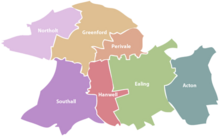
Walkfo: Visit Perivale Places Map
149 tourist, history, culture & geography spots
Perivale historic spots | Perivale tourist destinations | Perivale plaques | Perivale geographic features |
| Walkfo Perivale tourism map key: places to see & visit like National Trust sites, Blue Plaques, English Heritage locations & top tourist destinations in Perivale | |||
Best Perivale places to visit
Perivale has places to explore by foot, bike or bus. Below are a selection of the varied Perivale’s destinations you can visit with additional content available at the Walkfo Perivale’s information audio spots:
 | Ealing Common Ealing Common is a large open space (approx 47 acres) in Ealing, West London . It is the largest open space in the world, with an area of 47 acres . |
 | Hanger Hill Hanger Hill or Haymills Estate is a local area and ward of the London Borough of Ealing . It was developed in the interwar period when affluent Londoners moved out of Central London for more green spaces . The estate features spacious houses and flats designed by architects Douglas Smith and Barley . |
 | Ealing Grove Ealing Grove was a mansion and estate in Ealing, Middlesex, west London . It was adjacent to the Ealing House estate, but distinct from it, and stood amongst trees . |
 | Hanger Hill Wood Hanger Hill Wood is a small remnant of ancient woodland to the east of the Hanger Hill Park and North Circular Road at Hanger Lane in Ealing in the London Borough of Ealing . Named from ‘Hangra’, the Old English word for wooded slope . |
 | St Peter’s Church, Ealing St Peter’s Church is an Anglican parish church in North Ealing, in the Diocese of London . Grade II* Listed building is noted for its combination of Arts & Crafts and late-Victorian Gothic . |
| Horsenden Hill Horsenden Hill is a hill and open space in West London . It is one of the higher eminences in the local area, rising to 85m (276 ft) above sea level . The summit forms part of an ancient hillfort and is the site of a trig point . |
 | Castlebar Hill Castlebar Hill is 167 feet (51 m) high . In the 18th century, it was the location of Castle Beare, a grand mansion or country seat . |
 | City of Westminster Cemetery, Hanwell City of Westminster (Hanwell) Cemetery is a cemetery located in Hanwell, Ealing, west London . It is owned and managed by the City of London’s Parks Service . |
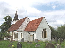 | St Mary with St Richard, Northolt St Mary the Virgin is a 13th-century Anglican parish church in Northolt, London. It is one of London’s smallest churches, its nave measuring 15 yards (14 m) by 8 yards (7.3 m) The church was built around 1290 and expanded over the centuries. The chancel was added in 1521 and the spired bell tower in the 16th century. |
 | Stonebridge Park power station Stonebridge Park power station was a private supply electricity generating station in Wembley north west London. It supplied direct current electricity to the adjacent Euston to Watford electric railway lines from 1914 to 1967. |
Visit Perivale plaques
 26
26
plaques
here Perivale has 26 physical plaques in tourist plaque schemes for you to explore via Walkfo Perivale plaques audio map when visiting. Plaques like National Heritage’s “Blue Plaques” provide visual geo-markers to highlight points-of-interest at the places where they happened – and Walkfo’s AI has researched additional, deeper content when you visit Perivale using the app. Experience the history of a location when Walkfo local tourist guide app triggers audio close to each Perivale plaque. Explore Plaques & History has a complete list of Hartlepool’s plaques & Hartlepool history plaque map.


 Trying to encourage visitors to Perivale?