Welcome to Visit Penwyllt Places
The Walkfo guide to things to do & explore in Penwyllt
 Visit Penwyllt places using Walkfo for free guided tours of the best Penwyllt places to visit. A unique way to experience Penwyllt’s places, Walkfo allows you to explore Penwyllt as you would a museum or art gallery with audio guides.
Visiting Penwyllt Walkfo Preview
Penwyllt (Welsh: “Wild Headland”) is located in the upper Swansea Valley in Powys, Wales. It is a former quarrying village, quicklime and silica brick production centre. Beneath it is the extensive limestone cave system of Ogof Ffynnon Ddu, part of the first designated underground national nature reserve. When you visit Penwyllt, Walkfo brings Penwyllt places to life as you travel by foot, bike, bus or car with a mobile phone & headphones.
Penwyllt Places Overview: History, Culture & Facts about Penwyllt
Visit Penwyllt – Walkfo’s stats for the places to visit
With 15 audio plaques & Penwyllt places for you to explore in the Penwyllt area, Walkfo is the world’s largest heritage & history digital plaque provider. The AI continually learns & refines facts about the best Penwyllt places to visit from travel & tourism authorities (like Wikipedia), converting history into an interactive audio experience.
Penwyllt history
Industrialisation
Penwyllt developed as a result of the need for quicklime in the industrial processes in the lower Swansea Valley. The company took limestone from the quarries and turned it into quicklime for lime kilns. Subsequently it also supported a company which quarried silica sand at Pwll Byfre to make refractory bricks.
Christie 1819-1822
In 1819 Fforest Fawr was enclosed or divided up into fields, and large parts of it became the property of John Christie, a Scottish businessman based in London. Christie developed a limestone quarry at Penwyllt and developed the Brecon Forest Tramroad. Christie was declared bankrupt in 1827 and most of his assets, including the tramroad, eventually passed to his principal creditor.
Claypon 1827-1850
Claypon took over Christie’s assets and concentrated on expanding the lime kilns at or around Penwyllt. They came to the conclusion that shipping lime, coal, iron ore and quicklime south to the larger industrial premises in the southern Swansea Valley was more productive than trying to serve a small rural population of the Usk valley.
Second half of the 19th century
Neath and Brecon Railway was built by Isambard Kingdom Brunel in 1862. It was the Dulais Valley Mineral Railway to transport goods to the docks at Briton Ferry, Neath built by Brunel. In 1863 the railway reached Crynant, coal mining quickly expanded.
Decline 1870
By 1870 the seven blast furnace ironworks of Ynyscedwyn had only one working furnace. Penwyllt declined with reducing economic stocks of coal, iron ore and limestone.
20th century
The Penwyllt Inn, or ‘Stump’ as it was often known, closed in 1948. In October 1962 all passenger services were withdrawn by British Rail from Neath and Brecon Railway line. By the end of the 1960s the population had fallen to 20 people. The railway line remained open south to Neath until 1977 to serve the quarry.
21st Century
The former Craig-y-nos/Penwyllt station survives in good repair as a private holiday cottage. Patti Row, a block of back-to-back houses dating from the days of the Brecon Forest Tramroad, survives in a derelict state. The former pub survives as private accommodation for cavers.
Penwyllt geography / climate
Penwyllt is a hamlet located in the upper Swansea Valley in Powys, Wales. It is located within the Brecon Beacons National Park.
Why visit Penwyllt with Walkfo Travel Guide App?
 You can visit Penwyllt places with Walkfo Penwyllt to hear history at Penwyllt’s places whilst walking around using the free digital tour app. Walkfo Penwyllt has 15 places to visit in our interactive Penwyllt map, with amazing history, culture & travel facts you can explore the same way you would at a museum or art gallery with information audio headset. With Walkfo, you can travel by foot, bike or bus throughout Penwyllt, being in the moment, without digital distraction or limits to a specific walking route. Our historic audio walks, National Trust interactive audio experiences, digital tour guides for English Heritage locations are available at Penwyllt places, with a AI tour guide to help you get the best from a visit to Penwyllt & the surrounding areas.
“Curated content for millions of locations across the UK, with 15 audio facts unique to Penwyllt places in an interactive Penwyllt map you can explore.”
Walkfo: Visit Penwyllt Places Map
15 tourist, history, culture & geography spots
Penwyllt historic spots | Penwyllt tourist destinations | Penwyllt plaques | Penwyllt geographic features |
| Walkfo Penwyllt tourism map key: places to see & visit like National Trust sites, Blue Plaques, English Heritage locations & top tourist destinations in Penwyllt | |||
Best Penwyllt places to visit
Penwyllt has places to explore by foot, bike or bus. Below are a selection of the varied Penwyllt’s destinations you can visit with additional content available at the Walkfo Penwyllt’s information audio spots:
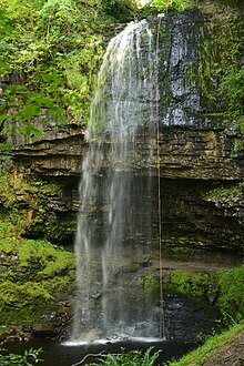 | Henrhyd Falls Henrhyd Falls is the tallest waterfall in southern Wales with a drop of 90 feet (27 m) It lies on National Trust land, in the county of Powys. The nearest settlement to it is Coelbren, on the road between Glynneath and Abercraf. |
 | Cribarth Cribarth, sometimes referred to as the Sleeping Giant, is a hill in the Brecon Beacons National Park in Powys (formerly Brecknockshire) in southern Wales. The summit lies on the broken ridge at an elevation of 428 m (1,404 ft) at OS grid reference SN 831143. |
 | Craig-y-Nos Castle Craig-y-nos Castle is a Victorian-Gothic country house in Powys, Wales. Built on parkland beside the River Tawe in the upper Swansea Valley, it is located on the southeastern edge of the Black Mountain. |
 | Dan yr Ogof Dan yr Ogof is a 17-kilometre (11 mi) long cave system in south Wales. It is the main feature of a show cave complex, which is claimed to be the largest in the UK. The bones of some 42 humans, as well as numerous animal bones, have been found in one of the nearby chambers. |
 | Ogof Ffynnon Ddu Ogof Ffynnon Ddu (Welsh for cave of the black spring) is a cave under a hillside in the area surrounding Penwyllt in the Upper Swansea Valley in South Wales. It is the second longest cave in Wales and the deepest in the United Kingdom. |
 | Carreg Cadno Carreg Cadno lies five miles northeast of Abercraf in the county of Powys, south Wales. It lies within the Brecon Beacons National Park and Fforest Fawr Geopark. Its summit at OS grid ref SN 874161 reaches a height of 538m / 1763 ft above sea level. |
Visit Penwyllt plaques
 0
0
plaques
here Penwyllt has 0 physical plaques in tourist plaque schemes for you to explore via Walkfo Penwyllt plaques audio map when visiting. Plaques like National Heritage’s “Blue Plaques” provide visual geo-markers to highlight points-of-interest at the places where they happened – and Walkfo’s AI has researched additional, deeper content when you visit Penwyllt using the app. Experience the history of a location when Walkfo local tourist guide app triggers audio close to each Penwyllt plaque. Currently No Physical Plaques.


 Trying to encourage visitors to Penwyllt?