Welcome to Visit Pembrokeshire Places
The Walkfo guide to things to do & explore in Pembrokeshire
 Visit Pembrokeshire places using Walkfo for free guided tours of the best Pembrokeshire places to visit. A unique way to experience Pembrokeshire’s places, Walkfo allows you to explore Pembrokeshire as you would a museum or art gallery with audio guides.
Visiting Pembrokeshire Walkfo Preview
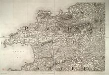
Pembrokeshire is a principal area in the preserved county of Dyfed, and an historic county of Wales . It is bordered by Carmarthenshire to the east, Ceredigion to the northeast, and the rest by sea . The county is 99 per cent white and its population was 122,439 at the 2011 census, an increase of 7.2 per cent . When you visit Pembrokeshire, Walkfo brings Pembrokeshire places to life as you travel by foot, bike, bus or car with a mobile phone & headphones.
Pembrokeshire Places Overview: History, Culture & Facts about Pembrokeshire
Visit Pembrokeshire – Walkfo’s stats for the places to visit
With 9 audio plaques & Pembrokeshire places for you to explore in the Pembrokeshire area, Walkfo is the world’s largest heritage & history digital plaque provider. The AI continually learns & refines facts about the best Pembrokeshire places to visit from travel & tourism authorities (like Wikipedia), converting history into an interactive audio experience.
Pembrokeshire history

Human habitation of the region that is now Pembrokeshire extends back to between 125,000 and 70,000 years. There are numerous prehistoric sites such as Pentre Ifan, and neolithic remains (12,000 to 6,500 years ago)
Roman period

Ptolemy’s Geography, written c. 150, mentioned some coastal places, two of which have been identified as the River Teifi and what is now St Davids Head, but most Roman writers did not mention the area . Part of a possible Roman road is noted by CADW near Llanddewi Velfrey and another near Wiston . Wiston is also the location of the first Roman fort discovered in Pembrokeshire in 2013 .
Sub-Roman period

Between 350 and 400, an Irish tribe settled in the region known to the Romans as Demetae . The Déisi merged with the local Welsh, with the regional name evolving into Dyfed . In 904, Hywel Dda married Elen (died 943), daughter of the king of Dyfed Llywarch ap Hyfaidd .
Norman period
Norman/Flemish influence never fully recovered in West Wales . The region became known as Pembroke after the Norman castle built in the cantref of Penfro . In 1136, Prince Owain Gwynedd at Crug Mawr near Cardigan met and destroyed a 3,000-strong Norman army .
Middle ages
The Statute of Rhuddlan established the rule of law in Wales in 1284 . The Laws in Wales Act 1535 effectively abolished the powers of the Marcher Lords and divided the county into seven hundreds . During the First English Civil War (1642–1646) the county gave strong support to the Roundheads (Parliamentarians), in contrast to the rest of Wales, which was staunchly Royalist .
18th and 19th centuries
In 1720, Pembrokeshire was described as having five market towns, 45 parishes and 4,329 houses . In 1791 a petition was presented to the House of Commons concerning the poor state of many of the county’s roads . After the Battle of Fishguard, the failed French invasion of 1797, 500 French prisoners were held at .
20th century

There was considerable military activity in Pembrokeshire and offshore in the 20th century . There was a naval base at Milford Haven because German U-boats were active off the coast in World War I . In World War II, 5,000 soldiers from the United States Army’s 110th Infantry Regiment were based in the county, preparing for D-Day .
Pembrokeshire culture & places
Flag
The flag of Pembrokeshire is a yellow cross on a blue field . In the centre of the cross is a green pentagon bearing a red and white Tudor rose .
Physical heritage

Pembrokeshire has more than 1,600 listed buildings under the auspices of Cadw and the County Council . The National Monuments Record of Wales identifies nearly 6,000 sites in the county as worthy of study .
The arts and media
Music festivals in Pembrokeshire include those at St Davids, Fishguard (folk, jazz and the International Music Festival) and Tenby (Blues Festival) There are museums and art galleries in several locations in the county, including Scolton Manor, Narberth, Tenby, Milford Haven and Fishguard .
Sport
Ironman Wales has been held in Pembrokeshire since 2011, contributing £3.7 million to the local economy . Haverfordwest RFC, founded in 1875, is a feeder club for Llanelli Scarlets . There are numerous football clubs in the county, playing in five leagues .
Notable people

Rhys ap Gruffydd (c. 1132-1197), ruler of the kingdom of Deheubarth, was buried in St Davids Cathedral . Henry Tudor (later Henry VII) was born in 1457 at Pembroke Castle . Jemima Nicholas, heroine of the so-called “last invasion of Britain” in 1797, was from Fishguard .
Pembrokeshire economy & business
Agriculture
Until the 12th century, a great extent of Pembrokeshire was virgin woodland . Clearance in the lowland south began under Anglo-Flemish colonisation and under mediaeval tenancies in other areas . Little is known about mediaeval farming methods, but much arable land was continuously cropped .
Fishing

Pembrokeshire Fish Week is a biennial event which in 2014 attracted 31,000 visitors and generated £3 million for the local economy . At its peak, Milford was landing over 40,000 tons of fish a year .
Mining
Slate quarrying was a significant industry in the 19th and early 20th centuries . Over 50 coal workings in the Pembrokeshire Coalfield were in existence between the 14th and 20th century . The last coal mine, at Kilgetty, closed in 1950 .
Oil, gas and renewable energy

There are two oil refineries, two liquified natural gas (LNG) terminals and the 2,000 MW gas-fired Pembroke Power Station at Milford Haven . The first solar energy farm in Wales was installed at Rhosygilwen, Rhoshill in 2011 .
Tourism
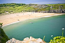
In 2015 4.3 million tourists visited the county, staying for an average of 5.24 days, spending £585 million . Pembrokeshire received the most coast awards in Wales, with 56 Blue Flag, Green Coast or Seaside Awards . In the 2019 Wales Coast Awards, 39 beaches were recognised, including 11 awarded Blue Flag status . In 2019 Consumers’ Association placed Tenby and St Davids in top three best value beach destinations in Britain .
Pembrokeshire geography / climate
Climate
There are three weather stations in Pembrokeshire: at Tenby, Milford Haven and Penycwm . The county has on average the highest coastal winter temperatures in Wales . Inland, average temperatures tend to fall 0.5 °C for each 100 metres increase in height .
Geology
The rocks in the county were formed between 600 and 290 million years ago . The landscape was subject to considerable change as a result of ice ages . Pembrokeshire is not usually a seismically active area, but in August 1892 there was a series of pronounced activities .
Coastline and landscape

The Pembrokeshire Coast National Park is the only park in the UK established primarily because of its coastline . The National Trust owns 60 miles (97 km) of the county’s coast . Nowhere in the county is more than 10 miles (16 km) from tidal water . The county has six lifeboat stations, the earliest of which was established in 1822 . The highest point is Foel Cwmcerwyn at 1,759 feet (536 m), which is also the highest point in the country .
Wildlife
Pembrokeshire’s wildlife is diverse, with marine, estuary, ancient woodland, moorland and farmland habitats . The county has a number of seasonal seabird breeding sites, including for razorbill, guillemot, puffin and Manx shearwater . The rare Southern damselfly, Coenagrion mercuriale, is found at several locations in the county .
Why visit Pembrokeshire with Walkfo Travel Guide App?
 You can visit Pembrokeshire places with Walkfo Pembrokeshire to hear history at Pembrokeshire’s places whilst walking around using the free digital tour app. Walkfo Pembrokeshire has 9 places to visit in our interactive Pembrokeshire map, with amazing history, culture & travel facts you can explore the same way you would at a museum or art gallery with information audio headset. With Walkfo, you can travel by foot, bike or bus throughout Pembrokeshire, being in the moment, without digital distraction or limits to a specific walking route. Our historic audio walks, National Trust interactive audio experiences, digital tour guides for English Heritage locations are available at Pembrokeshire places, with a AI tour guide to help you get the best from a visit to Pembrokeshire & the surrounding areas.
“Curated content for millions of locations across the UK, with 9 audio facts unique to Pembrokeshire places in an interactive Pembrokeshire map you can explore.”
Walkfo: Visit Pembrokeshire Places Map
9 tourist, history, culture & geography spots
Pembrokeshire historic spots | Pembrokeshire tourist destinations | Pembrokeshire plaques | Pembrokeshire geographic features |
| Walkfo Pembrokeshire tourism map key: places to see & visit like National Trust sites, Blue Plaques, English Heritage locations & top tourist destinations in Pembrokeshire | |||
Best Pembrokeshire places to visit
Pembrokeshire has places to explore by foot, bike or bus. Below are a selection of the varied Pembrokeshire’s destinations you can visit with additional content available at the Walkfo Pembrokeshire’s information audio spots:
![]()
Clarbeston Road railway station
Clarbeston Road railway station was opened by the South Wales Railway on 2 January 1854. The station, originally named ClarBeston, is located in Pembrokeshire, Wales. It was originally opened in 1854 and is now located in Wiston, Walton East and Crundale.
Visit Pembrokeshire plaques
 0
0
plaques
here Pembrokeshire has 0 physical plaques in tourist plaque schemes for you to explore via Walkfo Pembrokeshire plaques audio map when visiting. Plaques like National Heritage’s “Blue Plaques” provide visual geo-markers to highlight points-of-interest at the places where they happened – and Walkfo’s AI has researched additional, deeper content when you visit Pembrokeshire using the app. Experience the history of a location when Walkfo local tourist guide app triggers audio close to each Pembrokeshire plaque. Currently No Physical Plaques.


 Trying to encourage visitors to Pembrokeshire?