Welcome to Visit Peaslake Places
The Walkfo guide to things to do & explore in Peaslake
 Visit Peaslake places using Walkfo for free guided tours of the best Peaslake places to visit. A unique way to experience Peaslake’s places, Walkfo allows you to explore Peaslake as you would a museum or art gallery with audio guides.
Visiting Peaslake Walkfo Preview
Peaslake, Hoe, and Colman’s Hill are in the centre of the Surrey Hills AONB and mid-west of the Greensand Ridge about 5 miles (8.0 km) ESE of Guildford. The area referred to by the 2011 census covers 302 hectares (750 acres) Friends of the Hurtwood maintains and coppices 3,000 acres (1,200 ha) of surrounding forest. When you visit Peaslake, Walkfo brings Peaslake places to life as you travel by foot, bike, bus or car with a mobile phone & headphones.
Peaslake Places Overview: History, Culture & Facts about Peaslake
Visit Peaslake – Walkfo’s stats for the places to visit
With 21 audio plaques & Peaslake places for you to explore in the Peaslake area, Walkfo is the world’s largest heritage & history digital plaque provider. The AI continually learns & refines facts about the best Peaslake places to visit from travel & tourism authorities (like Wikipedia), converting history into an interactive audio experience.
Peaslake history
The earliest mention of Peaslake was in 1784, when Francis Haybitle left (to the vestry) a rentcharge of 15s. a year on a cottage in Shere to provide bread for the poor. A Working Men’s Institute that no longer exists was built in 1891 by the Misses Spottiswoode of Drydown. Most of the oldest extant houses were built in the brief Edwardian period (1901–1911)
Peaslake geography / climate
Peaslake is set in rolling meadows and forests in terms of topography, soil type and land use. Access to the village by car can only be gained by using roads which are at some point single track. All three adjoining small settlements are in the centre of the Surrey Hills and about 5 miles (8.0 km) from Guildford.
Hurtwood

In total, with 3,000 acres (1,200 ha) of surrounding forest, the Hurtwood comprises: Holmbury Hill, Pitch Hill, Winterfold, Shere Heath, Farley Heath and part of Blackheath Common. Three of the nine car parks within Hurtwood are closest to Peaslake.
Why visit Peaslake with Walkfo Travel Guide App?
 You can visit Peaslake places with Walkfo Peaslake to hear history at Peaslake’s places whilst walking around using the free digital tour app. Walkfo Peaslake has 21 places to visit in our interactive Peaslake map, with amazing history, culture & travel facts you can explore the same way you would at a museum or art gallery with information audio headset. With Walkfo, you can travel by foot, bike or bus throughout Peaslake, being in the moment, without digital distraction or limits to a specific walking route. Our historic audio walks, National Trust interactive audio experiences, digital tour guides for English Heritage locations are available at Peaslake places, with a AI tour guide to help you get the best from a visit to Peaslake & the surrounding areas.
“Curated content for millions of locations across the UK, with 21 audio facts unique to Peaslake places in an interactive Peaslake map you can explore.”
Walkfo: Visit Peaslake Places Map
21 tourist, history, culture & geography spots
Peaslake historic spots | Peaslake tourist destinations | Peaslake plaques | Peaslake geographic features |
| Walkfo Peaslake tourism map key: places to see & visit like National Trust sites, Blue Plaques, English Heritage locations & top tourist destinations in Peaslake | |||
Best Peaslake places to visit
Peaslake has places to explore by foot, bike or bus. Below are a selection of the varied Peaslake’s destinations you can visit with additional content available at the Walkfo Peaslake’s information audio spots:

Hurtwood House
Hurtwood House is a 15–19 mixed boarding school and sixth form near Dorking, Surrey, England. It is an independent boarding school with a sixth form and 15-19 students.

St James’s Church, Abinger Common
St James’s Church stands on Abinger Lane in Abinger Common, a small village within the civil parish of Abinger in Surrey. The church was built in the early 12th century and then rebuilt around 1220, and is today a grade II* listed building.
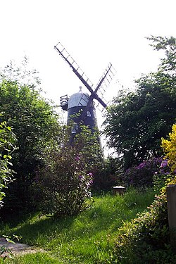
Hurt Wood Mill, Ewhurst
Hurt Wood Mill is a grade II* listed tower mill at Ewhurst, Surrey, England. It has been converted to residential use.
Visit Peaslake plaques
 0
0
plaques
here Peaslake has 0 physical plaques in tourist plaque schemes for you to explore via Walkfo Peaslake plaques audio map when visiting. Plaques like National Heritage’s “Blue Plaques” provide visual geo-markers to highlight points-of-interest at the places where they happened – and Walkfo’s AI has researched additional, deeper content when you visit Peaslake using the app. Experience the history of a location when Walkfo local tourist guide app triggers audio close to each Peaslake plaque. Currently No Physical Plaques.


 Trying to encourage visitors to Peaslake?