Welcome to Visit Osbaldwick Places
The Walkfo guide to things to do & explore in Osbaldwick
 Visit Osbaldwick places using Walkfo for free guided tours of the best Osbaldwick places to visit. A unique way to experience Osbaldwick’s places, Walkfo allows you to explore Osbaldwick as you would a museum or art gallery with audio guides.
Visiting Osbaldwick Walkfo Preview
Osbaldwick is a village and civil parish in the unitary authority of the City of York in North Yorkshire. The population of the civil parish as taken at the Census 2011 was 2,902. It is the burial place of the nun Mary Ward. When you visit Osbaldwick, Walkfo brings Osbaldwick places to life as you travel by foot, bike, bus or car with a mobile phone & headphones.
Osbaldwick Places Overview: History, Culture & Facts about Osbaldwick
Visit Osbaldwick – Walkfo’s stats for the places to visit
With 245 audio plaques & Osbaldwick places for you to explore in the Osbaldwick area, Walkfo is the world’s largest heritage & history digital plaque provider. The AI continually learns & refines facts about the best Osbaldwick places to visit from travel & tourism authorities (like Wikipedia), converting history into an interactive audio experience.
Osbaldwick history
Osbaldwick is mentioned three times in the Domesday Book as Osboldewic. It is named after an earl in the kingdom of Northumbria. It was the first Norman Archbishop of York that created the office of Prebend. The office was de facto lord of the manor of the village.
Osbaldwick landmarks
The village is home to Osbaldwick Hall, a Grade II Listed Building, and to the 12th century St. Thomas’s church. Eliza Raine was the first partner to the celebrated English landowner and diarist Anne Lister.
Osbaldwick geography / climate

Osbaldwick is now effectively a suburb of York, about 2 miles (3.2 km) east of the city. The village proper lies mostly along one street. Newer housing surrounds this and the village is bounded on three sides by the A1079 to the south, the A64 to the east and green-belt land to the north.
Demography
The 1881 UK Census recorded the population as 340. According to the 2001 UK Census the parish had a population of 2,726. There were 1,200 dwellings of which 364 were detached.
Why visit Osbaldwick with Walkfo Travel Guide App?
 You can visit Osbaldwick places with Walkfo Osbaldwick to hear history at Osbaldwick’s places whilst walking around using the free digital tour app. Walkfo Osbaldwick has 245 places to visit in our interactive Osbaldwick map, with amazing history, culture & travel facts you can explore the same way you would at a museum or art gallery with information audio headset. With Walkfo, you can travel by foot, bike or bus throughout Osbaldwick, being in the moment, without digital distraction or limits to a specific walking route. Our historic audio walks, National Trust interactive audio experiences, digital tour guides for English Heritage locations are available at Osbaldwick places, with a AI tour guide to help you get the best from a visit to Osbaldwick & the surrounding areas.
“Curated content for millions of locations across the UK, with 245 audio facts unique to Osbaldwick places in an interactive Osbaldwick map you can explore.”
Walkfo: Visit Osbaldwick Places Map
245 tourist, history, culture & geography spots
Osbaldwick historic spots | Osbaldwick tourist destinations | Osbaldwick plaques | Osbaldwick geographic features |
| Walkfo Osbaldwick tourism map key: places to see & visit like National Trust sites, Blue Plaques, English Heritage locations & top tourist destinations in Osbaldwick | |||
Best Osbaldwick places to visit
Osbaldwick has places to explore by foot, bike or bus. Below are a selection of the varied Osbaldwick’s destinations you can visit with additional content available at the Walkfo Osbaldwick’s information audio spots:
 | Clarence Street Clarence Street is a former rugby stadium in York, England. From 1885 until 1989 it was the home of York F.C. (later York R.L.F.C.) The site is now housing. |
 | York St John University York St John University (originally established as York Diocesan College), often abbreviated to YSJ, is a public university located on a large urban campus in York, England. It achieved university status in 2006 and in 2015 the University was given research degree awarding powers for PhD and doctoral programmes. |
| Wandesford House Wandesford House is one of twelve still-functioning almshouses in York, England. Built in 1739 and opened in 1743, the house is an important example of the classical style in the city. The almshouse is listed by Historic England as a Grade II* building. |
 | Gillygate Gillygate is a street in York, in England, immediately north of the city centre. It is located north of York’s city centre and is located in the centre of the town. The name of the street is “Gillygate” and “Gillgate” |
 | Ogleforth Ogleforth is a street in the city centre of York, in England. It is one of the streets in the centre of the city and is located in the north of York. |
 | Duncombe Place Duncombe Place is a street in the city centre of York, in England. Duncombe Street is one of the streets in the centre of the city. |
 | Monkgate Monkgate is a street in York, North Yorkshire running north-east from the city centre. It is one of the main streets in the North Yorkshire city of York. |
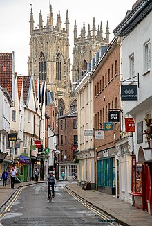 | Petergate Petergate is a street in the city centre of York, in England. It is divided into High Petergate and Low Petergate. The well-known view of the Minster is described by the City of York Council as “excellent” |
 | Museum Street (York) Museum Street is a road in the city centre of York, in England. It is one of the main roads in York and is located in the centre of the city. |
 | Goodramgate Goodramgate is a street in the city centre of York, in England. It is one of several streets in the centre of the city and is located in York. |
Visit Osbaldwick plaques
 154
154
plaques
here Osbaldwick has 154 physical plaques in tourist plaque schemes for you to explore via Walkfo Osbaldwick plaques audio map when visiting. Plaques like National Heritage’s “Blue Plaques” provide visual geo-markers to highlight points-of-interest at the places where they happened – and Walkfo’s AI has researched additional, deeper content when you visit Osbaldwick using the app. Experience the history of a location when Walkfo local tourist guide app triggers audio close to each Osbaldwick plaque. Explore Plaques & History has a complete list of Hartlepool’s plaques & Hartlepool history plaque map.


 Trying to encourage visitors to Osbaldwick?