Welcome to Visit Orford, Suffolk Places
The Walkfo guide to things to do & explore in Orford, Suffolk
 Visit Orford, Suffolk places using Walkfo for free guided tours of the best Orford, Suffolk places to visit. A unique way to experience Orford, Suffolk’s places, Walkfo allows you to explore Orford, Suffolk as you would a museum or art gallery with audio guides.
Visiting Orford, Suffolk Walkfo Preview
Orford is a village with historic town status in Suffolk, England, within the Suffolk Coast and Heaths AONB. It is located 9 miles (14 km) east of Woodbridge. When you visit Orford, Suffolk, Walkfo brings Orford, Suffolk places to life as you travel by foot, bike, bus or car with a mobile phone & headphones.
Orford, Suffolk Places Overview: History, Culture & Facts about Orford, Suffolk
Visit Orford, Suffolk – Walkfo’s stats for the places to visit
With 19 audio plaques & Orford, Suffolk places for you to explore in the Orford, Suffolk area, Walkfo is the world’s largest heritage & history digital plaque provider. The AI continually learns & refines facts about the best Orford, Suffolk places to visit from travel & tourism authorities (like Wikipedia), converting history into an interactive audio experience.
Orford, Suffolk history

Orford was of some importance as a port and fishing village in the Middle Ages. It has a mediaeval castle, built to dominate the River Ore and Grade I listed parish church. The castle was built as a royal castle built by Henry II in the period 1165-1173.
Why visit Orford, Suffolk with Walkfo Travel Guide App?
 You can visit Orford, Suffolk places with Walkfo Orford, Suffolk to hear history at Orford, Suffolk’s places whilst walking around using the free digital tour app. Walkfo Orford, Suffolk has 19 places to visit in our interactive Orford, Suffolk map, with amazing history, culture & travel facts you can explore the same way you would at a museum or art gallery with information audio headset. With Walkfo, you can travel by foot, bike or bus throughout Orford, Suffolk, being in the moment, without digital distraction or limits to a specific walking route. Our historic audio walks, National Trust interactive audio experiences, digital tour guides for English Heritage locations are available at Orford, Suffolk places, with a AI tour guide to help you get the best from a visit to Orford, Suffolk & the surrounding areas.
“Curated content for millions of locations across the UK, with 19 audio facts unique to Orford, Suffolk places in an interactive Orford, Suffolk map you can explore.”
Walkfo: Visit Orford, Suffolk Places Map
19 tourist, history, culture & geography spots
Orford, Suffolk historic spots | Orford, Suffolk tourist destinations | Orford, Suffolk plaques | Orford, Suffolk geographic features |
| Walkfo Orford, Suffolk tourism map key: places to see & visit like National Trust sites, Blue Plaques, English Heritage locations & top tourist destinations in Orford, Suffolk | |||
Best Orford, Suffolk places to visit
Orford, Suffolk has places to explore by foot, bike or bus. Below are a selection of the varied Orford, Suffolk’s destinations you can visit with additional content available at the Walkfo Orford, Suffolk’s information audio spots:
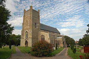 | St Bartholomew’s Church, Orford The Church of St Bartholomew is the parish church of Orford, England. It is a medieval medieval church dating from the fourteenth century. The church is notable as the location for the first performances of four of the works of the composer Benjamin Britten. |
 | Cobra Mist Cobra Mist was part of a small number of “Cobra” long-range surveillance radars operated by the U.S. It was originally intended to be mounted in Turkey and offer coverage of most of European Soviet airspace. When Turkey objected to the site it was moved to the UK and sited to offer a view of Eastern Europe. The main building and 12 towers remain; five are 340 feet high. |
 | Havergate Island Havergate Island is 2 miles (3.2 km) long and 1/2 mile (0.80 km) across at its widest point. It is a marshy nature reserve run by the Royal Society for the Protection of Birds (RSPB) The island lies in the Alder and Ore estuary and is protected from the North Sea by the shingle spit of Orford Ness. |
Visit Orford, Suffolk plaques
 1
1
plaques
here Orford, Suffolk has 1 physical plaques in tourist plaque schemes for you to explore via Walkfo Orford, Suffolk plaques audio map when visiting. Plaques like National Heritage’s “Blue Plaques” provide visual geo-markers to highlight points-of-interest at the places where they happened – and Walkfo’s AI has researched additional, deeper content when you visit Orford, Suffolk using the app. Experience the history of a location when Walkfo local tourist guide app triggers audio close to each Orford, Suffolk plaque. Explore Plaques & History has a complete list of Hartlepool’s plaques & Hartlepool history plaque map.


 Trying to encourage visitors to Orford, Suffolk?