Welcome to Visit Oldham Places
The Walkfo guide to things to do & explore in Oldham
 Visit Oldham places using Walkfo for free guided tours of the best Oldham places to visit. A unique way to experience Oldham’s places, Walkfo allows you to explore Oldham as you would a museum or art gallery with audio guides.
Visiting Oldham Walkfo Preview
Oldham rose to prominence in the 19th century as an international centre of textile manufacture . At its zenith, it was the most productive cotton spinning mill town in the world, producing more cotton than France and Germany combined . The demise of textile processing in Oldham depressed and heavily affected the local economy . Today Oldham is predominantly a commuter town . When you visit Oldham, Walkfo brings Oldham places to life as you travel by foot, bike, bus or car with a mobile phone & headphones.
Oldham Places Overview: History, Culture & Facts about Oldham
Visit Oldham – Walkfo’s stats for the places to visit
With 114 audio plaques & Oldham places for you to explore in the Oldham area, Walkfo is the world’s largest heritage & history digital plaque provider. The AI continually learns & refines facts about the best Oldham places to visit from travel & tourism authorities (like Wikipedia), converting history into an interactive audio experience.
Oldham history
Toponymy
The toponymy of Oldham seems to imply “old village or place” from Eald (Saxon) signifying oldness or antiquity . Oldham is known to be a derivative of Aldehulme, undoubtedly an Old Norse name . It is understood to date from 865, during the period of the Danelaw .
Early history
The earliest known evidence of a human presence in what is now Oldham is attested by the discovery of Neolithic flint arrow-heads and workings found at Werneth and Besom Hill . Placenames of Celtic origin are still to be found in Oldham . Oldham as a permanent, named place of dwelling is believed to date from 865 .
Industrial Revolution and cotton
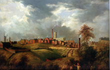
Much of Oldham’s history is concerned with textile manufacture during the Industrial Revolution; it has been said that “if ever the Industrial Revolution placed a town firmly and squarely on the map of the world, that town is Oldham.” Oldham’s soils were too thin and poor to sustain crop growing, and so for decades prior to industrialisation the area was used for grazing sheep, which provided the raw material for a local woollen weaving trade. By 1756, Oldham had emerged as centre of the hatting industry in England. The rough felt used in the production process is the origin of the term “Owdham Roughyed” a nickname for people from Oldham. It was not until the last quarter of the 18th century that Oldham changed from being a cottage industry township producing woollen garments via domestic manual labour, to a sprawling industrial metropolis of textile factories. The climate, geology, and topography of Oldham were unrelenting constraints upon the social and economic activities of the human inhabitants. At 700 feet (200 m) above sea level and with no major river or visible natural resources, Oldham had poor geographic attributes compared with other settlements for investors and their engineers. As a result, Oldham played no part in the initial period of the Industrial Revolution, although it did later become seen as obvious territory to industrialise because of its convenient position between the labour forces of Manchester and southwest Yorkshire. Cotton spinning and milling were introduced to Oldham when its first mill, Lees Hall, was built by William Clegg in about 1778, the beginning of a spiralling process of urbanisation and socioeconomic transformation. Within a year, 11 other mills had been constructed, and by 1818 there were 19 – not a large number in comparison with other local settlements. Oldham’s small local population was greatly increased by the mass migration of workers from outlying villages, resulting in a population increase from just over 12,000 in 1801 to 137,000 in 1901. The speed of this urban growth meant that Oldham, with little pre-industrial history to speak of, was effectively born as a factory town. Oldham became the world’s manufacturing centre for cotton spinning in the second half of the 19th century. In 1851, over 30% of Oldham’s population was employed within the textile sector, compared to 5% across Great Britain. It overtook the major urban centres of Manchester and Bolton as the result of a mill building boom in the 1860s and 1870s, a period during which Oldham became the most productive cotton-spinning town in the world. In 1871, Oldham had more spindles than any country in the world except the United States, and in 1909, was spinning more cotton than France and Germany combined. By 1911 there were 16.4 million spindles in Oldham, compared with a total of 58 million in the United Kingdom and 143.5 million in the world; in 1928, with the construction of the UK’s largest textile factory Oldham reached its manufacturing zenith. At its peak, there were more than 360 mills, operating night and day; Oldham’s townscape was dominated by distinctive rectangular brick-built mills. Oldham was hit hard by the Lancashire Cotton Famine of 1861–1865, when supplies of raw cotton from the United States were cut off. Wholly reliant upon the textile industry, the cotton famine created chronic unemployment in the town. By 1863 a committee had been formed, and with aid from central government, land was purchased with the intention of employing local cotton workers to construct Alexandra Park, which opened on 28 August 1865. Said to have over-relied upon the textile sector, as the importation of cheaper foreign yarns grew during the 20th century, Oldham’s economy declined into a depression, although it was not until 1964 that Oldham ceased to be the largest centre of cotton spinning. In spite of efforts to increase the efficiency and competitiveness of its production, the last cotton spun in the town was in 1998. Facilitated by its flourishing textile industry, Oldham developed extensive structural and mechanical engineering sectors during the 18th and 19th centuries. The manufacture of spinning and weaving machinery in Oldham belongs to the last decade of the 19th century, when it became a leading centre in the field of engineering. The Platt Brothers, originated in nearby Dobcross village, but moved to Oldham. They were pioneers of cotton-spinning machinery, developing innovative products that enabled the mass-production of cotton yarn. Platt Brothers became the largest textile machine makers in the world, employing over 15,000 people in the 1890s, twice the number of their nearest rivals Dobson & Barlow in Bolton and Asa Lees on Greenacres Moor. They were keen investors in the local area and at one time, were supporting 42% of the population. The centre of the company lay at the New Hartford Works in Werneth, a massive complex of buildings and internal railways on a site overlooking Manchester. The railway station which served this site later formed the basis of Oldham Werneth railway station. The main building exists to this day. Platts gained prestigious awards from around the world, and were heavily involved with local politics and civic pride in Oldham. John and James Platt were the largest subscribers for promoting Oldham from a township to a Borough, pledging £100 (more than double the next largest sum) in advance towards any expenses which may have been incurred by the Royal Charter. In 1854 John Platt was made the (fourth) Mayor of Oldham, an office he was to hold twice more in 1855–56 and 1861–62. John Platt was elected in 1865 to become a Member of Parliament (MP) for Oldham, and was re-elected in 1868; he remained in office until his death in 1872. A bronze statue of Platt existed in the town centre for years, though was moved to Alexandra Park. There have been recommendations for it to be returned to the town centre. Abraham Henthorn Stott, the son of a stonemason, was born in nearby Shaw & Crompton in 1822. He served a seven-year apprenticeship with Sir Charles Barry, before starting a structural engineering practice in Oldham in 1847 that went on to become the pre-eminent mill architect firm in Lancashire. Philip Sydney Stott, third son of Abraham and later titled as Sir Philip Stott, 1st Baronet, was the most prominent and famous of the Stott mill architects. He established his own practice in 1883 and designed over a hundred mills in several countries. His factories, which improved upon his father’s fireproof mills, accounted for a 40% increase in Oldham’s spindles between 1887 and 1914. Although textile-related engineering declined with the processing industry, leading to the demise of both Stotts and Platts, other engineering firms existed, notably electrical and later electronic engineers Ferranti in 1896. Ferranti went into receivership in 1993, but some of its former works continue in other hands. Part of the original Hollinwood site was operated by Siemens Metering and Semiconductor divisions. The remainder of the site is occupied by Mirror Colour Print Ltd; the printing division of Reach, which prints and distributes thirty-six major newspapers, and employs five hundred staff. On the back of the Industrial Revolution, Oldham developed an extensive coal mining sector, correlated to supporting the local cotton industry and the town’s inhabitants, though there is evidence of small scale coal mining in the area as early as the 16th century. The Oldham Coalfield stretched from Royton in the north to Bardsley in the south and in addition to Oldham, included the towns of Middleton and Chadderton to the west. The Oldham Coalfield was the site of over 150 collieries during its recorded history. Although some contemporary sources suggest there was coal mining in Oldham at a commercial scale by 1738, older sources attribute the commercial expansion of coal mining with the arrival in the town of two Welsh labourers, John Evans and William Jones, around 1770. Foreseeing the growth in demand for coal as a source of motive and steam power, they acquired colliery rights for Oldham, which by 1771 had 14 colliers. The mines were largely to the southwest of the town around Hollinwood and Werneth and provided enough coal to accelerate Oldham’s rapid development at the centre of the cotton boom. At its height in the mid-19th century, when it was dominated by the Lees and Jones families, Oldham coal was mainly sourced from many small collieries whose lives varied from a few years to many decades, although two of the four largest collieries survived to nationalisation. In 1851, collieries employed more than 2,000 men in Oldham, although the amount of coal in the town was somewhat overestimated however, and production began to decline even before that of the local spinning industry. Today, the only visible remnants of the mines are disused shafts and boreholes.
Social history
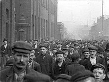
Oldham’s social history is marked by politicised civil disturbances, as well as events related to the Luddite, Suffragette and other Labour movements from the working classes . On 16 August 1819, Oldham sent a contingent estimated at well above 10,000 to hear speakers in St Peter’s Fields at Manchester discuss political reform; it was the largest contingent sent to Manchester . The Riot Act was read in 1852 on election day following a mass public brawl over the Reform Act, and irregularities with parliamentary candidate nominations . The 2001 riots prompted governmental and independent inquiries, which collectively agreed on community relations improvements and considerable regeneration schemes for the town .
Oldham culture & places

Oldham once had a peak of six “fine” theatres in 1908. Charlie Chaplin and Stan Laurel performed there in the early 20th century. The Lyceum is a Grade II listed building opened in 1856 at a cost of £6,500 as a “mutual improvement” centre.
Carnival
The annual Oldham Carnival started around 1900 . The parade was always held in mid-to-late summer with the primary aim of raising money for charities . The carnival fell out of favour in the late 1990s but was resurrected by community volunteers in 2006 and rebranded the Peoples’ Carnival .
Oldham landmarks
Town Hall
Grade II listed Georgian neo-classical town hall was built in 1841, eight years before Oldham received its borough status . Winston Churchill made his inaugural acceptance speech from the steps of the hall when he was first elected as a Conservative MP in 1900 . The structure stood empty for many years from the mid-1980s and was regularly earmarked for redevelopment as part of regeneration project proposals .
War memorial
Oldham’s war memorial consists of a granite base surmounted by a bronze sculpture depicting five soldiers making their way along the trenches in order to go into battle . The main standing figure, having climbed out of the trenches, is shown calling on his comrades to advance . The monument was intended to symbolise the spirit of 1914–1918 .
Civic Centre
The Civic Centre tower is the Metropolitan Borough of Oldham’s centre of local governance . The 15-storey white-brick building has housed the vast majority of the local government’s offices since its completion in 1977 . It was designed by Cecil Howitt & Partners, and the topping out ceremony was held on 18 June 1976 .
Parish Church
The Oldham Parish Church of St. Mary with St. Peter dates from 1830 . It was designed in the Gothic Revival Style by Richard Lane, a Manchester-based architect . It has been designated by English Heritage as a Grade II* listed building . A church building had existed on the site since 1280 .
Oldham geography / climate

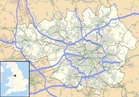
Oldham stands 700 feet (213 m) above sea level, 6.9 miles (11.1 km) northeast of Manchester city centre. It has an area of 6.91 square miles (17.90 km) Oldham’s topography is characterised by its rugged, elevated Pennine terrain. The town has no listed buildings with a Grade I rating.
Divisions and suburbs

Many of Oldham’s present divisions and suburbs have origins as pre-industrial hamlets, manorial commons and ancient chapelries . Oldham was surrounded by large swathes of moorland, reflected in placenames of Moorside, Greenacres moor, Littlemoor, Northmoor among others . A large portion of the residences are “low value” Victorian era red-brick terraced houses in a row formation, built for the most part from 1870 to 1920, to house the town’s cotton mill workers .
Why visit Oldham with Walkfo Travel Guide App?
 You can visit Oldham places with Walkfo Oldham to hear history at Oldham’s places whilst walking around using the free digital tour app. Walkfo Oldham has 114 places to visit in our interactive Oldham map, with amazing history, culture & travel facts you can explore the same way you would at a museum or art gallery with information audio headset. With Walkfo, you can travel by foot, bike or bus throughout Oldham, being in the moment, without digital distraction or limits to a specific walking route. Our historic audio walks, National Trust interactive audio experiences, digital tour guides for English Heritage locations are available at Oldham places, with a AI tour guide to help you get the best from a visit to Oldham & the surrounding areas.
“Curated content for millions of locations across the UK, with 114 audio facts unique to Oldham places in an interactive Oldham map you can explore.”
Walkfo: Visit Oldham Places Map
114 tourist, history, culture & geography spots
Oldham historic spots | Oldham tourist destinations | Oldham plaques | Oldham geographic features |
| Walkfo Oldham tourism map key: places to see & visit like National Trust sites, Blue Plaques, English Heritage locations & top tourist destinations in Oldham | |||
Best Oldham places to visit
Oldham has places to explore by foot, bike or bus. Below are a selection of the varied Oldham’s destinations you can visit with additional content available at the Walkfo Oldham’s information audio spots:
![]()
Chadderton F.C.
Chadderton Football Club is a football club in Oldham, Greater Manchester. They are currently members of the North West Counties League Division One North and play at Andrew Street.

Chadderton Hall Park
Chadderton Hall Park is a park in the Metropolitan Borough of Oldham, Greater Manchester. It contains a large field area with a small football pitch, a playground area, several flower gardens and a small café situated next to the Park’s bowling green.

Textile Mill, Chadderton
Half of the building was destroyed by fire on 11 July 1950. The remaining section continued to be used for cotton waste sorting by W. H. Holt and Son until 1988.

Cowhill, Greater Manchester
Cowhill (archaically Cow Hill) is a locality of Chadderton, in the Metropolitan Borough of Oldham, Greater Manchester. It is located 0.5 miles (0.80 km) southeast of the town centre close to its eastern boundary with Oldham. An ancient hamlet which grew into an industrial village, Cowhill is now a residential area and includes a large housing development, Crossley Estate.

Hartford Mill
Hartford Mill was a Grade II-listed building located off Block Lane, in the Freehold area of Oldham, UK. The mill was located in the Oldham area of Freehold and is Grade II listed above Block Lane.

Manor Mill, Chadderton
Manor Mill, Chadderton is an early twentieth century, five storey cotton spinning mill. It was taken over by the Lancashire Cotton Corporation in the 1930s and passed to Courtaulds in 1964. Production finished in 1990.
Werneth Park
Werneth Park is a public park in Oldham, Greater Manchester. It includes a Grade II* listed Community Centre, Music Rooms, Dame Sarah Lees Memorial, Gardens and sports facilities.

Werneth Hall
Werneth Hall is a Grade II* listed privately owned Jacobean manor house in Oldham, Greater Manchester. It was built in 17th century and is now owned by a private family.

Royd Mill, Oldham
Royd Mill, Oldham was built in 1907 and extended in 1912 and 1924. It was taken over by the Lancashire Cotton Corporation in the 1930s and passed to Courtaulds in 1964. The mill was demolished in 2015 to make way for a housing scheme.

Orme Mill, Waterhead
Orme Mill, Waterhead is a cotton spinning mill in Waterhead, Oldham, Greater Manchester. It was built in 1908 and was taken over by Lancashire Cotton Corporation in the 1930s. Production finished in 1960 and the mill was passed on to Ferranti in 1964.
Visit Oldham plaques
 10
10
plaques
here Oldham has 10 physical plaques in tourist plaque schemes for you to explore via Walkfo Oldham plaques audio map when visiting. Plaques like National Heritage’s “Blue Plaques” provide visual geo-markers to highlight points-of-interest at the places where they happened – and Walkfo’s AI has researched additional, deeper content when you visit Oldham using the app. Experience the history of a location when Walkfo local tourist guide app triggers audio close to each Oldham plaque. Explore Plaques & History has a complete list of Hartlepool’s plaques & Hartlepool history plaque map.


 Trying to encourage visitors to Oldham?