Welcome to Visit Nutfield, Surrey Places
The Walkfo guide to things to do & explore in Nutfield, Surrey
 Visit Nutfield, Surrey places using Walkfo for free guided tours of the best Nutfield, Surrey places to visit. A unique way to experience Nutfield, Surrey’s places, Walkfo allows you to explore Nutfield, Surrey as you would a museum or art gallery with audio guides.
Visiting Nutfield, Surrey Walkfo Preview
Nutfield is a village and civil parish in the Tandridge District of Surrey. It lies in the Weald immediately south of the Greensand Ridge and has a railway station at South Nutfield which is one stop from Redhill. When you visit Nutfield, Surrey, Walkfo brings Nutfield, Surrey places to life as you travel by foot, bike, bus or car with a mobile phone & headphones.
Nutfield, Surrey Places Overview: History, Culture & Facts about Nutfield, Surrey
Visit Nutfield, Surrey – Walkfo’s stats for the places to visit
With 28 audio plaques & Nutfield, Surrey places for you to explore in the Nutfield, Surrey area, Walkfo is the world’s largest heritage & history digital plaque provider. The AI continually learns & refines facts about the best Nutfield, Surrey places to visit from travel & tourism authorities (like Wikipedia), converting history into an interactive audio experience.
Nutfield, Surrey history
Nutfield appears in Domesday Book of 1086 as Notfelle. It was held by Countess Ida of Boulogne (2nd wife of Count Eustace) Its domesday assets were: 3 hides; 1 church, 16 ploughs, 1 mill worth 2s, 10 acres (40,000 m) of meadow, herbage worth 12 hogs. Grade II* listed St Peter and St Paul’s church was built in 13th century.
Why visit Nutfield, Surrey with Walkfo Travel Guide App?
 You can visit Nutfield, Surrey places with Walkfo Nutfield, Surrey to hear history at Nutfield, Surrey’s places whilst walking around using the free digital tour app. Walkfo Nutfield, Surrey has 28 places to visit in our interactive Nutfield, Surrey map, with amazing history, culture & travel facts you can explore the same way you would at a museum or art gallery with information audio headset. With Walkfo, you can travel by foot, bike or bus throughout Nutfield, Surrey, being in the moment, without digital distraction or limits to a specific walking route. Our historic audio walks, National Trust interactive audio experiences, digital tour guides for English Heritage locations are available at Nutfield, Surrey places, with a AI tour guide to help you get the best from a visit to Nutfield, Surrey & the surrounding areas.
“Curated content for millions of locations across the UK, with 28 audio facts unique to Nutfield, Surrey places in an interactive Nutfield, Surrey map you can explore.”
Walkfo: Visit Nutfield, Surrey Places Map
28 tourist, history, culture & geography spots
Nutfield, Surrey historic spots | Nutfield, Surrey tourist destinations | Nutfield, Surrey plaques | Nutfield, Surrey geographic features |
| Walkfo Nutfield, Surrey tourism map key: places to see & visit like National Trust sites, Blue Plaques, English Heritage locations & top tourist destinations in Nutfield, Surrey | |||
Best Nutfield, Surrey places to visit
Nutfield, Surrey has places to explore by foot, bike or bus. Below are a selection of the varied Nutfield, Surrey’s destinations you can visit with additional content available at the Walkfo Nutfield, Surrey’s information audio spots:
| SES Water SES Water is the UK water supply company to its designated area of east Surrey, West Sussex, west Kent and south London. An area of 322 square miles (830 km) extends from Morden and South Croydon in the north to Gatwick Airport in the south, and from Cobham and Dorking in the west to Edenbridge and Bough Beech in the east. |
 | Wray Common Mill, Reigate Wray Common Mill is a grade II* listed tower mill at Reigate, Surrey, England. It has been converted to residential use. |
 | St John’s, Redhill St John’s is in its wider definition one of the three ecclesiastical parishes that make up Redhill, Surrey. The small elevated residential community occupies a conservation area circled by Earlswood and wooded Redhill Common. |
| Earlswood railway station (Surrey) Earlswood is on the Brighton Main Line, 21 miles 50 chains (34.8 km) down the line from London Bridge via Redhill and south of the junction between the Redhill line and Quarry line. Train services are provided by Thameslink and Southern. |
 | Royal Earlswood Hospital The Royal Earlswood Hospital was the first establishment to cater specifically for people with developmental disabilities. Previously they had been housed either in asylums for the mentally ill or in workhouses. |
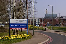 | East Surrey Hospital East Surrey Hospital is a National Health Service hospital in the Whitebushes area to the south of Redhill, in Surrey, England. It is managed by the Surrey and Sussex Healthcare NHS Trust. |
 | Redhill F.C. Redhill F.C. are currently members of the Combined Counties League Premier Division South and play at Kiln Brow. The club is affiliated to the Surrey County Football Association. |
Visit Nutfield, Surrey plaques
 0
0
plaques
here Nutfield, Surrey has 0 physical plaques in tourist plaque schemes for you to explore via Walkfo Nutfield, Surrey plaques audio map when visiting. Plaques like National Heritage’s “Blue Plaques” provide visual geo-markers to highlight points-of-interest at the places where they happened – and Walkfo’s AI has researched additional, deeper content when you visit Nutfield, Surrey using the app. Experience the history of a location when Walkfo local tourist guide app triggers audio close to each Nutfield, Surrey plaque. Currently No Physical Plaques.


 Trying to encourage visitors to Nutfield, Surrey?