Welcome to Visit Nidderdale AONB Places
The Walkfo guide to things to do & explore in Nidderdale AONB
 Visit Nidderdale AONB places using Walkfo for free guided tours of the best Nidderdale AONB places to visit. A unique way to experience Nidderdale AONB’s places, Walkfo allows you to explore Nidderdale AONB as you would a museum or art gallery with audio guides.
Visiting Nidderdale AONB Walkfo Preview
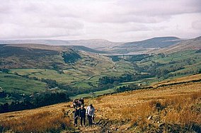
The Nidderdale AONB is an Area of Outstanding Natural Beauty in North Yorkshire, England. It is said to contain “remains from over 6,000 years of human activity”; there is evidence of “almost continuous settlement over this time with the exception of the Roman period for which evidence is scanty” It covers a total area of 233 square miles (600 km) The highest point is Great Whernside, 704 metres above sea level. When you visit Nidderdale AONB, Walkfo brings Nidderdale AONB places to life as you travel by foot, bike, bus or car with a mobile phone & headphones.
Nidderdale AONB Places Overview: History, Culture & Facts about Nidderdale AONB
Visit Nidderdale AONB – Walkfo’s stats for the places to visit
 With 11 audio plaques & Nidderdale AONB places for you to explore in the Nidderdale AONB area, Walkfo is the world’s largest heritage & history digital plaque provider. The AI continually learns & refines facts about the best Nidderdale AONB places to visit from travel & tourism authorities (like Wikipedia), converting history into an interactive audio experience.
Nidderdale AONB history
Nidderdale was not included in the Yorkshire Dales National Park when it was designated in 1954. In 1963 the then West Riding County Council proposed that Nidderdal should be added to the National Park, but the proposal met with opposition from the district councils. The West Riding National Park Committee did not entirely abandon the idea until 1988, when the alternative AONB designation was proposed.
Nidderdale AONB geography / climate
Nidderdale

The AONB includes all of Nidderdale except a small area in the lower dale around Hampsthwaite. Lower dale attractions include Brimham Rocks and the Coldstones Cut. In the less populated upper dale there are a series of reservoirs.
Lower Wharfedale and the Washburn Valley

The southern part of the AONB includes the reservoirs of the Washburn Valley, Lindley Wood, Swinsty, Fewston and Fewston.
Lower Wensleydale and side valleys
Fountains Abbey and Jervaulx Abbey both lie within the AONB. Hackfall Wood is on the south bank of the River Ure.
Why visit Nidderdale AONB with Walkfo Travel Guide App?
 You can visit Nidderdale AONB places with Walkfo Nidderdale AONB to hear history at Nidderdale AONB’s places whilst walking around using the free digital tour app. Walkfo Nidderdale AONB has 11 places to visit in our interactive Nidderdale AONB map, with amazing history, culture & travel facts you can explore the same way you would at a museum or art gallery with information audio headset. With Walkfo, you can travel by foot, bike or bus throughout Nidderdale AONB, being in the moment, without digital distraction or limits to a specific walking route. Our historic audio walks, National Trust interactive audio experiences, digital tour guides for English Heritage locations are available at Nidderdale AONB places, with a AI tour guide to help you get the best from a visit to Nidderdale AONB & the surrounding areas.
“Curated content for millions of locations across the UK, with 11 audio facts unique to Nidderdale AONB places in an interactive Nidderdale AONB map you can explore.”
Walkfo: Visit Nidderdale AONB Places Map
11 tourist, history, culture & geography spots
Nidderdale AONB historic spots | Nidderdale AONB tourist destinations | Nidderdale AONB plaques | Nidderdale AONB geographic features |
| Walkfo Nidderdale AONB tourism map key: places to see & visit like National Trust sites, Blue Plaques, English Heritage locations & top tourist destinations in Nidderdale AONB | |||
Best Nidderdale AONB places to visit
Nidderdale AONB has places to explore by foot, bike or bus. Below are a selection of the varied Nidderdale AONB’s destinations you can visit with additional content available at the Walkfo Nidderdale AONB’s information audio spots:
Nidderdale AONB
The Nidderdale AONB is an Area of Outstanding Natural Beauty in North Yorkshire, England. It is said to contain “remains from over 6,000 years of human activity”; there is evidence of “almost continuous settlement over this time with the exception of the Roman period for which evidence is scanty” It covers a total area of 233 square miles (600 km) The highest point is Great Whernside, 704 metres above sea level.
Visit Nidderdale AONB plaques
 12
12
plaques
here Nidderdale AONB has 12 physical plaques in tourist plaque schemes for you to explore via Walkfo Nidderdale AONB plaques audio map when visiting. Plaques like National Heritage’s “Blue Plaques” provide visual geo-markers to highlight points-of-interest at the places where they happened – and Walkfo’s AI has researched additional, deeper content when you visit Nidderdale AONB using the app. Experience the history of a location when Walkfo local tourist guide app triggers audio close to each Nidderdale AONB plaque. Explore Plaques & History has a complete list of Hartlepool’s plaques & Hartlepool history plaque map.


 Trying to encourage visitors to Nidderdale AONB?