Welcome to Visit Mumbai Places
The Walkfo guide to things to do & explore in Mumbai
 Visit Mumbai places using Walkfo for free guided tours of the best Mumbai places to visit. A unique way to experience Mumbai’s places, Walkfo allows you to explore Mumbai as you would a museum or art gallery with audio guides.
Visiting Mumbai Walkfo Preview
Mumbai is the capital city of the Indian state of Maharashtra. As of 2018, it is the second-most populous city in the country after Delhi. Mumbai lies on the Konkan coast on the west coast of India and has a deep natural harbour. Mumbai is home to three UNESCO World Heritage Sites: the Elephanta Caves, Chhatrapati Shivaji Maharaj Terminus, and the city’s distinctive ensemble of Victorian and Art Deco buildings. When you visit Mumbai, Walkfo brings Mumbai places to life as you travel by foot, bike, bus or car with a mobile phone & headphones.
Mumbai Places Overview: History, Culture & Facts about Mumbai
Visit Mumbai – Walkfo’s stats for the places to visit
With 24 audio plaques & Mumbai places for you to explore in the Mumbai area, Walkfo is the world’s largest heritage & history digital plaque provider. The AI continually learns & refines facts about the best Mumbai places to visit from travel & tourism authorities (like Wikipedia), converting history into an interactive audio experience.
Mumbai history
Early history
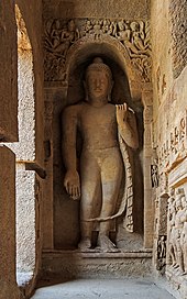
Mumbai is built on what was once an archipelago of seven islands: Isle of Bombay, Parel, Mazagaon, Mahim, Colaba, Worli, and Old Woman’s Island. Pleistocene sediments found along the coastal areas around Kandivali in northern Mumbai suggest that the islands were inhabited since the South Asian Stone Age. The islands formed part of the Maurya Empire, during its expansion in the south, ruled by the Buddhist emperor Ashoka of Magadha.
Portuguese and British rule

The Mughal Empire, founded in 1526, was the dominant power in the Indian subcontinent during the mid-16th century. Growing apprehensive of the power of the Mughal emperor Humayun, Sultan Bahadur Shah of Gujarat was obliged to sign the Treaty of Bassein with the Portuguese Empire on 23 December 1534. According to the treaty, the Seven Islands of Bombay, the nearby strategic town of Bassein and its dependencies were offered to the Portuguese. The territories were later surrendered on 25 October 1535. The Portuguese were actively involved in the foundation and growth of their Roman Catholic religious orders in Bombay. They called the islands by various names, which finally took the written form Bombaim. The islands were leased to several Portuguese officers during their regime. The Portuguese Franciscans and Jesuits built several churches in the city, prominent being the St. Michael’s Church at Mahim (1534), St. John the Baptist Church at Andheri (1579), St. Andrew’s Church at Bandra (1580), and Gloria Church at Byculla (1632). The Portuguese also built several fortifications around the city like the Bombay Castle, Castella de Aguada (Castelo da Aguada or Bandra Fort), and Madh Fort. The English were in constant struggle with the Portuguese vying for hegemony over Bombay, as they recognised its strategic natural harbour and its natural isolation from land attacks. By the middle of the 17th century the growing power of the Dutch Empire forced the English to acquire a station in western India. On 11 May 1661, the marriage treaty of Charles II of England and Catherine of Braganza, daughter of King John IV of Portugal, placed the islands in possession of the English Empire, as part of Catherine’s dowry to Charles. However, Salsette, Bassein, Mazagaon, Parel, Worli, Sion, Dharavi, and Wadala still remained under Portuguese possession. From 1665 to 1666, the English managed to acquire Mahim, Sion, Dharavi, and Wadala. In accordance with the Royal Charter of 27 March 1668, England leased these islands to the English East India Company in 1668 for a sum of £10 per annum. The population quickly rose from 10,000 in 1661, to 60,000 in 1675. The islands were subsequently attacked by Yakut Khan, the Muslim Koli admiral of the Mughal Empire, in October 1672, Rickloffe van Goen, the Governor-General of Dutch India on 20 February 1673, and Siddi admiral Sambal on 10 October 1673. In 1687, the English East India Company transferred its headquarters from Surat to Bombay. The city eventually became the headquarters of the Bombay Presidency. Following the transfer, Bombay was placed at the head of all the company’s establishments in India. Towards the end of the 17th century, the islands again suffered incursions from Yakut Khan in 1689–90. The Portuguese presence ended in Bombay when the Marathas under Peshwa Baji Rao I captured Salsette in 1737, and Bassein in 1739. By the middle of the 18th century, Bombay began to grow into a major trading town, and received a huge influx of migrants from across India. Later, the British occupied Salsette on 28 December 1774. With the Treaty of Surat (1775), the British formally gained control of Salsette and Bassein, resulting in the First Anglo-Maratha War. The British were able to secure Salsette from the Marathas without violence through the Treaty of Purandar (1776), and later through the Treaty of Salbai (1782), signed to settle the outcome of the First Anglo-Maratha War. From 1782 onwards, the city was reshaped with large-scale civil engineering projects aimed at merging all the seven islands of Bombay into a single amalgamated mass by way of a causeway called the Hornby Vellard, which was completed by 1784. In 1817, the British East India Company under Mountstuart Elphinstone defeated Baji Rao II, the last of the Maratha Peshwa in the Battle of Khadki. Following his defeat, almost the whole of the Deccan Plateau came under British suzerainty, and was incorporated into the Bombay Presidency. The success of the British campaign in the Deccan marked the end of all attacks by native powers. By 1845, the seven islands coalesced into a single landmass by the Hornby Vellard project via large scale land reclamation. On 16 April 1853, India’s first passenger railway line was established, connecting Bombay to the neighbouring town of Thana (now Thane). During the American Civil War (1861–1865), the city became the world’s chief cotton-trading market, resulting in a boom in the economy that subsequently enhanced the city’s stature. The opening of the Suez Canal in 1869 transformed Bombay into one of the largest seaports on the Arabian Sea. In September 1896, Bombay was hit by a bubonic plague epidemic where the death toll was estimated at 1,900 people per week. About 850,000 people fled Bombay and the textile industry was adversely affected. While the city was the capital of the Bombay Presidency, the Indian independence movement fostered the Quit India Movement in 1942 and the Royal Indian Navy mutiny in 1946.
Independent India

After India’s independence in 1947, the territory of the Bombay Presidency retained by India was restructured into Bombay State. The Samyukta Maharashtra movement to create a separate Maharashtra state including Bombay was at its height in the 1950s. Following protests during the movement in which 105 people lost their lives in clashes with the police, Bombay State was reorganised on linguistic lines on 1 May 1960. Gujarati-speaking areas of Bombay State were partitioned into the state of Gujarat.
Mumbai culture & places

Mumbai’s culture is a blend of traditional festivals, food, music, and theatres. The city’s history as a major trading centre has led to a diverse range of cultures, religions, and cuisines coexisting in the city. Mumbai is the birthplace of Indian cinema, with Dadasaheb Phalke laying the foundations with silent movies.
Mumbai etymology
The name Mumbai is derived from Mumbā or Mahā-Ambā—the name of the patron goddess (kuladevata) Mumbadevi of the native Koli community— and ā’ī meaning “mother” in the Marathi language. The oldest known names for the city are Kakamuchee and Galajunkja; these are sometimes still used. In 1508, Portuguese writer Gaspar Correia used the name “Bombaim” in his Lendas da Índia (“Legends of India”) The Government of India officially changed the English name to Mumbai in November 1995.
People from Mumbai
A resident of Mumbai is called Mumbaikar in Marathi, in which the suffix kar means a resident of. The term had been in use for quite some time but it gained popularity after the official name change to Mumbai. Older terms such as Bombayite are also in use.
Mumbai geography / climate
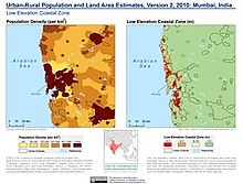
Mumbai consists of two distinct regions: Mumbai City district and Mumbai Suburban district, which form two separate revenue districts of Maharashtra. Mumbai lies at the mouth of the Ulhas River on the western coast of India, in the coastal region known as the Konkan. It sits on Salsette Island (Sashti Island), which it partially shares with the Thane district. Mumbai sits on a seismically active zone owing to the presence of 23 fault lines in the vicinity.
Climate
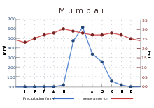
Mumbai has a tropical climate, specifically a tropical wet and dry climate (Aw) under the Köppen climate classification. It varies between a dry period extending from October to May and a wet period peaking in June. The maximum annual rainfall ever recorded was 3,452 mm (136 in) for 1954. Highest rainfall recorded in a single day was 944 mm (37 in) on 26 July 2005. The average annual temperature is 27 °C (81 °F) and average annual precipitation is 2,167 mm (85 in)
Why visit Mumbai with Walkfo Travel Guide App?
 You can visit Mumbai places with Walkfo Mumbai to hear history at Mumbai’s places whilst walking around using the free digital tour app. Walkfo Mumbai has 24 places to visit in our interactive Mumbai map, with amazing history, culture & travel facts you can explore the same way you would at a museum or art gallery with information audio headset. With Walkfo, you can travel by foot, bike or bus throughout Mumbai, being in the moment, without digital distraction or limits to a specific walking route. Our historic audio walks, National Trust interactive audio experiences, digital tour guides for English Heritage locations are available at Mumbai places, with a AI tour guide to help you get the best from a visit to Mumbai & the surrounding areas.
“Curated content for millions of locations across the UK, with 24 audio facts unique to Mumbai places in an interactive Mumbai map you can explore.”
Walkfo: Visit Mumbai Places Map
24 tourist, history, culture & geography spots
Mumbai historic spots | Mumbai tourist destinations | Mumbai plaques | Mumbai geographic features |
| Walkfo Mumbai tourism map key: places to see & visit like National Trust sites, Blue Plaques, English Heritage locations & top tourist destinations in Mumbai | |||
Best Mumbai places to visit
Mumbai has places to explore by foot, bike or bus. Below are a selection of the varied Mumbai’s destinations you can visit with additional content available at the Walkfo Mumbai’s information audio spots:
 | Don Bosco Institute of Technology, Mumbai Don Bosco Institute of Technology is a private engineering college situated at Kurla (West), Mumbai affiliated with the University of Mumbai. It has been granted a “Religious Minority” status (Roman Catholics) The institute was awarded ‘B++’grade in 2019 by NAAC. |
 | Amchi Shala Amchi Shala is a Marathi medium school. It was founded by Shri. J. K. Karmalkar in Tilak Nagar, Chembur, Mumbai, in 1961. |
Visit Mumbai plaques
 0
0
plaques
here Mumbai has 0 physical plaques in tourist plaque schemes for you to explore via Walkfo Mumbai plaques audio map when visiting. Plaques like National Heritage’s “Blue Plaques” provide visual geo-markers to highlight points-of-interest at the places where they happened – and Walkfo’s AI has researched additional, deeper content when you visit Mumbai using the app. Experience the history of a location when Walkfo local tourist guide app triggers audio close to each Mumbai plaque. Currently No Physical Plaques.


 Trying to encourage visitors to Mumbai?