Welcome to Visit Mottingham Places
The Walkfo guide to things to do & explore in Mottingham
 Visit Mottingham places using Walkfo for free guided tours of the best Mottingham places to visit. A unique way to experience Mottingham’s places, Walkfo allows you to explore Mottingham as you would a museum or art gallery with audio guides.
Visiting Mottingham Walkfo Preview
When you visit Mottingham, Walkfo brings Mottingham places to life as you travel by foot, bike, bus or car with a mobile phone & headphones.
Mottingham Places Overview: History, Culture & Facts about Mottingham
Visit Mottingham – Walkfo’s stats for the places to visit
With 87 audio plaques & Mottingham places for you to explore in the Mottingham area, Walkfo is the world’s largest heritage & history digital plaque provider. The AI continually learns & refines facts about the best Mottingham places to visit from travel & tourism authorities (like Wikipedia), converting history into an interactive audio experience.
Mottingham history
Toponymy
The earliest records of Mottingham are from 862 AD when it was recorded as Modingahema, which means the land of Moda’s people . In King Edward the Confessor’s confirmation of the gift of Elthruda, King Alfred’s niece, of the manor of Lewisham and its appendages, to the abbey of St. Peter’s, at Ghent, in Flanders, in 1044 . The bounds and extent of the hamlet of Modyngham are described in an ancient MS. remaining among registers of the bishop of Rochester .
Landmarks

The first church in Mottingham was St Andrew’s Church on Court Road, which was established in 1884 . The church helped establish the town as separate from Eltham .
Education

Mottingham geography / climate

Mottingham borders Eltham to the north, Chislehurst to the south, Elmstead to the. west, Lewisham and Lee to the west. Since 2010, the town has fallen within the Motting and Chislehurts North polling and policing districts.
Quaggy
A tributary of the River Quaggy flows through Mottingham, a small river known as the Little Quagggy . It flows through The Tarn and emerges alongside the Sidcup bypass to join the Quaggy . The Little Quagy flows to Mottingam playing fields (colloquially known as Foxes)
Mottingham Estate
London County Council bought the Court Farm estate in the early 1930s and planned a 2000 home cottage estate . The first houses were to the west of Mottingham Road and completed in 1935 . The community facilities included a shopping centre and several schools .
Coldharbour Estate
Woolwich Council built the Coldharbour Estate to the east of Mottingham Road in 1946 . It was built to provide accommodation for local people made homeless by the Blitz .
Why visit Mottingham with Walkfo Travel Guide App?
 You can visit Mottingham places with Walkfo Mottingham to hear history at Mottingham’s places whilst walking around using the free digital tour app. Walkfo Mottingham has 87 places to visit in our interactive Mottingham map, with amazing history, culture & travel facts you can explore the same way you would at a museum or art gallery with information audio headset. With Walkfo, you can travel by foot, bike or bus throughout Mottingham, being in the moment, without digital distraction or limits to a specific walking route. Our historic audio walks, National Trust interactive audio experiences, digital tour guides for English Heritage locations are available at Mottingham places, with a AI tour guide to help you get the best from a visit to Mottingham & the surrounding areas.
“Curated content for millions of locations across the UK, with 87 audio facts unique to Mottingham places in an interactive Mottingham map you can explore.”
Walkfo: Visit Mottingham Places Map
87 tourist, history, culture & geography spots
Mottingham historic spots | Mottingham tourist destinations | Mottingham plaques | Mottingham geographic features |
| Walkfo Mottingham tourism map key: places to see & visit like National Trust sites, Blue Plaques, English Heritage locations & top tourist destinations in Mottingham | |||
Best Mottingham places to visit
Mottingham has places to explore by foot, bike or bus. Below are a selection of the varied Mottingham’s destinations you can visit with additional content available at the Walkfo Mottingham’s information audio spots:
 | Downham Fields Downham Fields is a 20-acre park located in Downham, South East London . It was left as parkland during the construction of the interwar Downham Estate . It is sometimes referred to in documents by the name Durham Hill, but this is not in common usage . |
 | Boone’s Chapel Boone’s Chapel is a single-storey building attributed to Sir Christopher Wren and built in 1683 . The chapel is listed Grade I on the National Heritage List for England . |
 | Kemnal Park Cemetery & Memorial Gardens Kemnal Park Cemetery & Memorial Gardens was opened in October 2013 by the Mayor of Bromley, Cllr Ernest Noad . It comprises 55 acres in total and has 30,000 burial plots . The cemetery is also listed as a ‘site of special interest’ due to its ancient woodland and diverse bird life . |
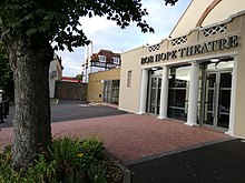 | The Bob Hope Theatre The Bob Hope Theatre is a community theatre in Eltham in Greenwich, England. The theatre is owned and run by the members of Elthetham Little Theatre Company. Members present approximately 11 shows each year. |
Visit Mottingham plaques
 24
24
plaques
here Mottingham has 24 physical plaques in tourist plaque schemes for you to explore via Walkfo Mottingham plaques audio map when visiting. Plaques like National Heritage’s “Blue Plaques” provide visual geo-markers to highlight points-of-interest at the places where they happened – and Walkfo’s AI has researched additional, deeper content when you visit Mottingham using the app. Experience the history of a location when Walkfo local tourist guide app triggers audio close to each Mottingham plaque. Explore Plaques & History has a complete list of Hartlepool’s plaques & Hartlepool history plaque map.


 Trying to encourage visitors to Mottingham?