Welcome to Visit Morvah Places
The Walkfo guide to things to do & explore in Morvah
 Visit Morvah places using Walkfo for free guided tours of the best Morvah places to visit. A unique way to experience Morvah’s places, Walkfo allows you to explore Morvah as you would a museum or art gallery with audio guides.
Visiting Morvah Walkfo Preview
Morvah is a civil parish and village on the Penwith peninsula in west Cornwall, England, United Kingdom. The village is located on the peninsula of Penwith Peninsula, west Cornwall. When you visit Morvah, Walkfo brings Morvah places to life as you travel by foot, bike, bus or car with a mobile phone & headphones.
Morvah Places Overview: History, Culture & Facts about Morvah
Visit Morvah – Walkfo’s stats for the places to visit
With 39 audio plaques & Morvah places for you to explore in the Morvah area, Walkfo is the world’s largest heritage & history digital plaque provider. The AI continually learns & refines facts about the best Morvah places to visit from travel & tourism authorities (like Wikipedia), converting history into an interactive audio experience.
Morvah history
Antiquities
Evidence of a settlement at Morvah in the early Middle Ages is in the form of an inscribed stone known as the Mên Scryfa. It is a memorial to one ‘Rialobranus son of Cunovalus’, located in a field on a moor about three kilometres from the village.
Morvah Gold Hoard
In 1884, a hoard of gold ornaments was found dating from the late Bronze Age in Cornwall. The hoard of six large bracelets were almost certainly either made in Ireland or made from Irish gold. They made their way, probably through trade in exchange for tin, to Cornwall. They now reside in the British Museum but are a vivid reminder of how relatively well-off Cornwall was in prehistoric times.
Mining
Morvah Consols was probably first opened in the 1820s and in 1851 was reported in the Cornish Telegraph newspaper as a new copper mine. In 1875 the Stanneries Court closed the mine after it only produced 5 tons 18 cwt of tin concentrate and wages had not been paid. A second engine was bought from the Balleswidden Mine for pumping and stamping and was put up for auction in February 1884.
Morvah geography / climate
Morvah is located eight miles (13 km) west-southwest of St Ives and 5+1/2 miles (8.9 km) north-west of Penzance. The parish consists of 1,270 acres (5 km) of land, 1-acre (0.40 ha) of water and 14 acres of foreshore. The South West Coast Path, which follows the coast of south west England from Somerset to Dorset, passes by on the cliffs.
Why visit Morvah with Walkfo Travel Guide App?
 You can visit Morvah places with Walkfo Morvah to hear history at Morvah’s places whilst walking around using the free digital tour app. Walkfo Morvah has 39 places to visit in our interactive Morvah map, with amazing history, culture & travel facts you can explore the same way you would at a museum or art gallery with information audio headset. With Walkfo, you can travel by foot, bike or bus throughout Morvah, being in the moment, without digital distraction or limits to a specific walking route. Our historic audio walks, National Trust interactive audio experiences, digital tour guides for English Heritage locations are available at Morvah places, with a AI tour guide to help you get the best from a visit to Morvah & the surrounding areas.
“Curated content for millions of locations across the UK, with 39 audio facts unique to Morvah places in an interactive Morvah map you can explore.”
Walkfo: Visit Morvah Places Map
39 tourist, history, culture & geography spots
Morvah historic spots | Morvah tourist destinations | Morvah plaques | Morvah geographic features |
| Walkfo Morvah tourism map key: places to see & visit like National Trust sites, Blue Plaques, English Heritage locations & top tourist destinations in Morvah | |||
Best Morvah places to visit
Morvah has places to explore by foot, bike or bus. Below are a selection of the varied Morvah’s destinations you can visit with additional content available at the Walkfo Morvah’s information audio spots:
 | Tregeseal East stone circle Tregeseal East (Cornish: Meyn an Dons, meaning “Stones of the Dance”; grid reference SW386323) is a heavily restored prehistoric stone circle. It is one surviving circle of three that once stood aligned along an east–west axis on the hillside to the south of Carn Kenidjack. |
 | Trewellard Trewellard (from Cornish: Trewylard, meaning “Gwylard’s settlement”; grid reference SW376337) is a small village on the north coast road between St Just and St Ives in Cornwall. Almost a third of Cornwall has AONB designation, with the same status and protection as a National Park. |
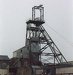 | Geevor Tin Mine Geevor Tin Mine is a tin mine in the far west of Cornwall. It was operational between 1911 and 1990 during which time it produced about 50,000 tons of black tin. It is now a museum and heritage centre left as a living history of a working tin mine. |
 | Boscaswell Boscaswell (Cornish: Boscaswal) is a village in the extreme west of Cornwall. It lies towards the cliffs from Pendeen, looking west across fields to the Atlantic Ocean. The village consists mainly of terraced cottages and a council house estate. |
 | Lanyon Quoit Lanyon Quoit is a dolmen in Cornwall, England, United Kingdom, 2 miles southeast of Morvah. It collapsed in a storm in 1815 and was re-erected nine years later. |
 | Ding Dong mines The Ding Dong mines lie in an old and extensive mining area situated in the parish of Madron, in Penwith, Cornwall. They are about two miles north east of the St Just to Penzance road. The site has been a UNESCO World Heritage Site since 2006. |
 | St Bridget’s Church, Morvah St Bridget’s Church, Morvah is a parish church in the Church of England Diocese of Truro. It was licensed for divine service by the Bishop of Exeter on 22 September 1400. The tower is the only remaining medieval part of the church. The nave and chancel were rebuilt in 1828. |
 | Aire Point to Carrick Du SSSI Aire Point to Carrick Du SSSI is a Site of Special Scientific Interest on the Penwith Peninsula, Cornwall. It is 5.98 square kilometres in extent, stretching from grid reference SW360279 to SW513410. The whole of the site is included in the Cornwall Area of Outstanding Natural Beauty. |
 | Boskednan stone circle Boskednan stone circle (grid reference SW434351) is a partially restored prehistoric stone circle. It is located 4 miles (6 kilometres) northwest of Penzance in Cornwall. The original structure may have contained as many as 22 upright stones around its 69-metre perimeter. |
 | West Lanyon Quoit West Lanyon Quoit is the remains of a prehistoric dolmen situated in the parish of Madron in Cornwall. It was excavated in the late 18th century and much of the structure has since been destroyed. |
Visit Morvah plaques
 0
0
plaques
here Morvah has 0 physical plaques in tourist plaque schemes for you to explore via Walkfo Morvah plaques audio map when visiting. Plaques like National Heritage’s “Blue Plaques” provide visual geo-markers to highlight points-of-interest at the places where they happened – and Walkfo’s AI has researched additional, deeper content when you visit Morvah using the app. Experience the history of a location when Walkfo local tourist guide app triggers audio close to each Morvah plaque. Currently No Physical Plaques.


 Trying to encourage visitors to Morvah?