Welcome to Visit Montpelier, Brighton Places
The Walkfo guide to things to do & explore in Montpelier, Brighton
 Visit Montpelier, Brighton places using Walkfo for free guided tours of the best Montpelier, Brighton places to visit. A unique way to experience Montpelier, Brighton’s places, Walkfo allows you to explore Montpelier, Brighton as you would a museum or art gallery with audio guides.
Visiting Montpelier, Brighton Walkfo Preview
Montpelier is an inner suburban area of Brighton, part of the English city and seaside resort of Brighton and Hove. Developed together with the adjacent Clifton Hill area in the mid-19th century, it forms a high-class, architecturally cohesive residential district. Stucco-clad terraced housing and villas predominate, but two of the city’s most significant Victorian churches and landmark hospital building are also in the area. When you visit Montpelier, Brighton, Walkfo brings Montpelier, Brighton places to life as you travel by foot, bike, bus or car with a mobile phone & headphones.
Montpelier, Brighton Places Overview: History, Culture & Facts about Montpelier, Brighton
Visit Montpelier, Brighton – Walkfo’s stats for the places to visit
With 218 audio plaques & Montpelier, Brighton places for you to explore in the Montpelier, Brighton area, Walkfo is the world’s largest heritage & history digital plaque provider. The AI continually learns & refines facts about the best Montpelier, Brighton places to visit from travel & tourism authorities (like Wikipedia), converting history into an interactive audio experience.
Montpelier, Brighton history

The South Downs, a range of chalk hills, surrounded the ancient fishing and farming village of Brighton (formerly Brighthelmston). The downland pasture sloped down to the English Channel coast and was farmed in one of two ways: some parts were divided into strips according to a local system of “laines”, furlongs” and “paul-pieces”, and other areas were left for the grazing of sheep. The area now covered by Montpelier was an example of the latter. The five laines around Brighton were based on land with a relatively gentle slope; when the gradient or height made the land too difficult to work, no more strips were marked out and the rest of the land was given over to grazing. A map of Brighton from the 1740s shows that a large section in the northwest of the parish—north of West Laine, west of North Laine and bisected by the road to Steyning—was marked as “sheep down”. It had no official name at the time, but by 1792 it had become known as Church Hill in reference to St Nicholas Church, the parish church of Brighton which stood on a hillock near the road. The part west of the road was sometimes described as “Church Hill – West Side”; the corresponding “East Side” later became known as West Hill during Brighton’s 19th-century growth. The road became a turnpike in 1777, increasing its importance, and became known as Dyke Road. Vine’s Mill, one of several windmills built on the Downs around Brighton, was erected in 1810. The sheep down was not common land: its ownership has been traced back to the 11th century (to Canute, Earl Godwin and his son King Harold), and by the late 18th century it was held by two influential local landowners. Thomas Kemp held about 41 acres (17 ha), and John Sackville, 3rd Duke of Dorset owned over 5 acres (2.0 ha). When Kemp died in 1811, his landholding transferred to his son Thomas Read Kemp. The Kemp family first acquired the land in 1770, when it was sold to them by the Friend family—whose history of large-scale land acquisition around Brighton goes back to the late 16th century and the purchase of the former St Bartholomew’s Priory and its grounds. Thomas Read Kemp had moved out of Brighton in 1807, but decided to return in 1819. By this time he was enjoying “a rich social life” and his considerable inherited wealth. As he owned so much land around Brighton, there were many sites he could choose for his new home; he selected a remote site near the track (running from the seafront to the Ditchling Road) which later became Montpelier Road. At the time there were only three people living on the farmland of “Church Hill – West Side”, including an eccentric former marine corporal who occupied a cave in a former chalk pit. He had been invalided out of the Navy after fighting in the Battle of Copenhagen in 1801, but retained his military interest: he made chalk models to sell, and rigged up four pistols to form a miniature battery which he would fire to celebrate military anniversaries. Read Kemp’s house, probably designed by Amon Wilds or his son Amon Henry Wilds, was called The Temple (and was popularly nicknamed “Kemp’s Folly” or “the Brighton Mansion”). He may have chosen the secluded site because it was close to the chalybeate spring at St Ann’s Well in the neighbouring parish of Hove, popularised by Dr Richard Russell in the 1750s but known to generations of shepherds before that for the health-giving effect it had on their sheep. The iron-rich water was used in “a primitive little spa” for about 100 years, and the associated Pump Room and gardens were popular with visitors long after that. The increasing popularity of Brighton as a resort resulted in an “exponential growth in housing”. In 1783, just after the first expansion outside the ancient four-street village, there were 600 houses; in 1801 there were 1,282, by 1811 another 1,096 had been completed, and in 1821 there were 4,299. The land of Church Hill was ideal for development—land ownership was not complex, unlike in many of the laines, and the sheltered southwest-facing slopes were close to both St Ann’s Well and the centre of Brighton’s fashionable social scene around Old Steine. The area developed rapidly as a residential district from the 1820s, and was one of the earliest of Brighton’s many 19th-century suburbs. From 1823, Read Kemp became heavily involved in his speculative Kemp Town estate on the edge of Brighton, and he moved to a house there in 1827 (after which The Temple became a boys’ school). He began selling plots of land throughout the area, and streets and areas of housing took shape. Montpelier Road was one of the first to develop, on the site of the long track which had given Read Kemp access to the seafront from his house; it is not named before 1820, but it appears on a map of 1822. Houses such as numbers 53–56, by Amon Henry Wilds, and the semi-detached villas of numbers 91–96, date from about 1830. Hampton Place, a sloping terrace of “especially pretty houses”, was an 1820s development by speculator William Hallett, who occupied one of the houses himself. Around the same time, Amon Henry Wilds and Charles Busby built several houses on a former track which became Clifton Road, and work started at Montpelier Terrace with the construction of a pair of villas in 1823. Montpelier Lodge (c. 1830) on Montpelier Terrace stood out from the surrounding stuccoed buildings due to its red-brick walls; it also had an elaborate entrance with Doric columns and a delicately patterned fanlight. Development accelerated after Thomas Read Kemp was declared bankrupt in 1837, forcing him to sell all his land and move to France. Parcels of land were rapidly developed with terraced streets (especially to the south, leading up from Western Road) and set-piece squares and crescents. The Temple was still isolated until 1834–35, when the firm of George Cheesman & Son built a new vicarage for the Vicar of Brighton Henry Michell Wagner. The “austere Neo-Tudor” house stood back from the nearest road. In about 1840, Wagner’s sister moved to the newly built Belvedere House nearby, and encouraged development of the adjacent road which became Montpelier Place. (The four-storey houses of Belvedere Terrace were built on her behalf in the grounds of Belvedere House in about 1852.) Brighton was connected to the railway network in 1840 when a line to Shoreham-by-Sea opened, followed in 1841 by the completion of the link to London. This stimulated growth even further, and the 1840s were a boom period for Montpelier. (Brighton as a whole grew rapidly in the 1840s—between 1841 and 1851, 2,806 new houses were built compared to 437 for the preceding decade—but the effect was greater in Montpelier because the station was close by at the foot of West Hill.) During the 1840s, Montpelier Villas and Montpelier Crescent were laid out, several houses were built in Clifton Road, Montpelier Road and Montpelier Terrace were fully built up, Upper North Street became an important route lined with “modest yet grandly treated” houses, the “very attractive composition” of Clifton Terrace was built (it was finished in 1847), Victoria Street was laid out with bay-fronted terraced houses, and Windlesham House was constructed near The Temple. This became the New Sussex Hospital in 1921 after alterations by the Clayton & Black architecture firm, but is now flats called Temple Heights. Developments in the 1850s included Powis Square, Villas and Road, Norfolk Terrace and Vernon Terrace. The Powis area took its name from property developer John Yearsley, who was from Welshpool in Powys. Yearsley bought several acres of land on a leasehold basis from the Kemp family in 1846; he acquired the freehold soon after. (Thomas Read Kemp died in France in 1844, seven years after leaving Brighton to escape his debts.) Land was also acquired and developed by the prominent Hallett, Wisden, Baring and Faithfull families. (The Baring baronets were related to Thomas Read Kemp by marriage; Henry Faithfull, who worked with Yearsley to develop the Powis area, was the brother of MP George Faithfull; and Thomas and John Wisden were prolific builders.) Denmark Terrace, a continuation of Vernon Terrace, was erected in the 1860s; at its south end it met Temple Gardens, the road on which The Temple stood. Also of the 1860s were parts of Norfolk Road (where development had started 30 years before), St Michael’s Place (1868–69) with terraced houses “impressive in their length and height”, and some infill development in Montpelier Terrace, Clifton Place, Powis Road and Vernon Terrace. Montpelier’s residential development was nearly complete by the 1870s, as suggested by an Ordnance Survey map of that time which shows undeveloped fields only in the area beyond Vernon Terrace. In 1870 or 1871, Brighton Children’s Hospital—established three years earlier in Western Road—moved to a new building on the site of the former Church Road School in West Hill. In 1880–81, Thomas Lainson built the new Royal Alexandra Hospital for Sick Children nearby at the junction of Dyke Road and Clifton Hill. It was extended and altered in 1904, 1906 and 1927–28. Some more houses were built in the Edwardian era, mostly in the characteristic Edwardian style with bright red brick “standing out amongst the stucco”. Examples include some in Temple Gardens and Vernon Gardens in the 1890s, a row on one side of Denmark Terrace, Windlesham Road (where numbers 14 and 16, built in 1903, are especially elaborate) and 18–25 Clifton Road (1903–04, with ornate gables and turreted corners). In 1902, the London & Brighton Express Electric Railway Company sought permission to build a new surface railway line from Westminster to a terminus near the junction of Montpelier Road and Western Road, passing Clifton Hill. Hove Council supported the parliamentary Bill, but nothing came of it; when the promoters proposed it again in 1903, the council were no longer interested. Additions and alterations to the streetscape have been minimal since the early 20th century. Windlesham House became the New Sussex Hospital for Women in 1921 following alterations by Clayton & Black, who similarly rebuilt a 19th-century house on Montpelier Road as a chapel for Brighton’s Christian Scientist community in the same year. The hospital was extended to the rear in the 1930s (but new flats called York Mansions were built on the site in 2001), and the Royal Alexandra Hospital absorbed a neighbouring villa. Additions to the Brighton & Hove High School, which had taken over The Temple, included a “drab” set of classrooms in the 1960s, a later administration block and a glazed sports hall in 2001–02 (the last two were designed by architects Morgan Carn Partnership). Demolitions included the former Emanuel Reformed Episcopal Church on Norfolk Terrace (replaced by a Baptist church) in 1965, The Dials Congregational Church in 1972 (built in 1871; replaced by sheltered accommodation) and Belvedere House (replaced in the 1970s by the Park Royal flats). Other blocks of flats were built in that decade on spare land on Montpelier Terrace and Clifton Terrace.
Why visit Montpelier, Brighton with Walkfo Travel Guide App?
 You can visit Montpelier, Brighton places with Walkfo Montpelier, Brighton to hear history at Montpelier, Brighton’s places whilst walking around using the free digital tour app. Walkfo Montpelier, Brighton has 218 places to visit in our interactive Montpelier, Brighton map, with amazing history, culture & travel facts you can explore the same way you would at a museum or art gallery with information audio headset. With Walkfo, you can travel by foot, bike or bus throughout Montpelier, Brighton, being in the moment, without digital distraction or limits to a specific walking route. Our historic audio walks, National Trust interactive audio experiences, digital tour guides for English Heritage locations are available at Montpelier, Brighton places, with a AI tour guide to help you get the best from a visit to Montpelier, Brighton & the surrounding areas.
“Curated content for millions of locations across the UK, with 218 audio facts unique to Montpelier, Brighton places in an interactive Montpelier, Brighton map you can explore.”
Walkfo: Visit Montpelier, Brighton Places Map
218 tourist, history, culture & geography spots
Montpelier, Brighton historic spots | Montpelier, Brighton tourist destinations | Montpelier, Brighton plaques | Montpelier, Brighton geographic features |
| Walkfo Montpelier, Brighton tourism map key: places to see & visit like National Trust sites, Blue Plaques, English Heritage locations & top tourist destinations in Montpelier, Brighton | |||
Best Montpelier, Brighton places to visit
Montpelier, Brighton has places to explore by foot, bike or bus. Below are a selection of the varied Montpelier, Brighton’s destinations you can visit with additional content available at the Walkfo Montpelier, Brighton’s information audio spots:
 | St Luke’s Church, Queen’s Park, Brighton St Luke’s Church is an Anglican church in the Queen’s Park area of Brighton. It was designed in the 1880s by Sir Arthur Blomfield in the Early English style. It has been given listed building status because of its architectural importance. |
 | Greek Orthodox Church of the Holy Trinity, Brighton The Church of the Holy Trinity is a Greek Orthodox church in Brighton. Built in 1838 in one of Brighton’s most notorious slum districts, Carlton Hill. It was an Anglican church for most of its life until it was declared redundant in 1980. It has been listed at Grade II since 1971. |
 | St Mary the Virgin, Brighton St Mary’s Church is an Anglican church in the Kemptown area of Brighton. The present building dates from the late 1870s and replaced a church of the same name which collapsed while being renovated. The Gothic-style red-brick building is now a Grade II* listed building. |
 | Church of the Annunciation, Brighton The Church of the Annunciation was built in the 1860s on behalf of Rev. Arthur Wagner. It served a new area of poor housing in what is now the Hanover district. The church is a Grade II listed building. |
 | Royal Crescent, Brighton Royal Crescent is a crescent-shaped terrace of houses on the seafront in Brighton, part of the English city of Brighton and Hove. Built in the late 18th and early 19th century as a speculative development on the open cliffs east of Brighton by a wealthy merchant. English Heritage has listed the crescent at Grade II* for its architectural and historical importance. |
 | Waste House Waste House is a building on the University of Brighton campus in the centre of Brighton on the south coast of England. It was built between 2012 and 2014 as a project involving hundreds of students and apprentices. The materials consist of a wide range of construction industry and household waste. It is the first public building in Europe to be built primarily of such products. |
 | St Wilfrid’s Church, Brighton St Wilfrid’s Church is a former Anglican church in the Elm Grove area of Brighton, part of the English city of Brighton and Hove. It was declared redundant after less than 50 years as a place of worship, and was converted into sheltered housing with minimal alteration to the exterior. |
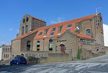
 | Dorset Gardens Methodist Church Dorset Gardens Methodist Church is the third Methodist place of worship on the site. It replaced an older, larger church which was in turn a rebuilding of Brighton’s first Methodist church. Between them, the churches have played an important part in the history of Methodism in Brighton. |
 | The Blind Tiger Club, Brighton The Blind Tiger Club was a mixed music, arts and community venue in Brighton, England, which opened in 2010. Time Out described the venue as “semi-legendary”, in its round-up of Brighton’s live music scene that year. Gigwise included the club in their list of the UK’s Greatest Lost Venues. |
 | St Joseph’s Church, Brighton St Joseph’s Church is a Roman Catholic church in the Elm Grove area of Brighton, part of the English city of Brighton and Hove. It is one of eleven Roman Catholic churches in the city. The church was built in several stages, and outstanding debts meant that its official dedication took place in 1979. |
Visit Montpelier, Brighton plaques
 154
154
plaques
here Montpelier, Brighton has 154 physical plaques in tourist plaque schemes for you to explore via Walkfo Montpelier, Brighton plaques audio map when visiting. Plaques like National Heritage’s “Blue Plaques” provide visual geo-markers to highlight points-of-interest at the places where they happened – and Walkfo’s AI has researched additional, deeper content when you visit Montpelier, Brighton using the app. Experience the history of a location when Walkfo local tourist guide app triggers audio close to each Montpelier, Brighton plaque. Explore Plaques & History has a complete list of Hartlepool’s plaques & Hartlepool history plaque map.


 Trying to encourage visitors to Montpelier, Brighton?