Welcome to Visit Mochrum Places
The Walkfo guide to things to do & explore in Mochrum
 Visit Mochrum places using Walkfo for free guided tours of the best Mochrum places to visit. A unique way to experience Mochrum’s places, Walkfo allows you to explore Mochrum as you would a museum or art gallery with audio guides.
Visiting Mochrum Walkfo Preview
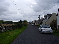
Mochrum is situated to the east of Luce Bay on the Machars peninsula and 8 miles (13 km) southwest of Wigtown. It covers 22,000 acres (8,900 ha) and is approximately 10 miles (16 km) in length and 5 miles (8.0 km) wide. The parish contains the eponymous village, as well as Port William and the clachan of Elrig. When you visit Mochrum, Walkfo brings Mochrum places to life as you travel by foot, bike, bus or car with a mobile phone & headphones.
Mochrum Places Overview: History, Culture & Facts about Mochrum
Visit Mochrum – Walkfo’s stats for the places to visit
With 3 audio plaques & Mochrum places for you to explore in the Mochrum area, Walkfo is the world’s largest heritage & history digital plaque provider. The AI continually learns & refines facts about the best Mochrum places to visit from travel & tourism authorities (like Wikipedia), converting history into an interactive audio experience.
Mochrum history
Sir John Dunbar of Mochrum was killed at the Battle of Flodden in 1513. His third son Gavin Dunbar became Archbishop of Glasgow in 1524. A fortified mediaeval manor house is located at Castle Island, also called Drumwalt.
Mochrum etymology
Mochrum is a Cumbric name formed of the elements moch ‘pigs, swine’ and drum ‘ridge’ It is possible, but unlikely, that the name is Gaelic.
Why visit Mochrum with Walkfo Travel Guide App?
 You can visit Mochrum places with Walkfo Mochrum to hear history at Mochrum’s places whilst walking around using the free digital tour app. Walkfo Mochrum has 3 places to visit in our interactive Mochrum map, with amazing history, culture & travel facts you can explore the same way you would at a museum or art gallery with information audio headset. With Walkfo, you can travel by foot, bike or bus throughout Mochrum, being in the moment, without digital distraction or limits to a specific walking route. Our historic audio walks, National Trust interactive audio experiences, digital tour guides for English Heritage locations are available at Mochrum places, with a AI tour guide to help you get the best from a visit to Mochrum & the surrounding areas.
“Curated content for millions of locations across the UK, with 3 audio facts unique to Mochrum places in an interactive Mochrum map you can explore.”
Walkfo: Visit Mochrum Places Map
3 tourist, history, culture & geography spots
Mochrum historic spots | Mochrum tourist destinations | Mochrum plaques | Mochrum geographic features |
| Walkfo Mochrum tourism map key: places to see & visit like National Trust sites, Blue Plaques, English Heritage locations & top tourist destinations in Mochrum | |||
Best Mochrum places to visit
Mochrum has places to explore by foot, bike or bus. Below are a selection of the varied Mochrum’s destinations you can visit with additional content available at the Walkfo Mochrum’s information audio spots:
 | Elrig Elrig (Scottish Gaelic: An Eileirg, meaning “the deer run”) is a clachan or hamlet in the historical county of Wigtownshire in Dumfries and Galloway, Scotland. Located in the Machars peninsula, it is about 3 miles (5 km) north of Port William. Elrig is the birthplace of author and naturalist Gavin Maxwell. The house was built in 1912 for his parents Aymer and Lady Mary Maxwell by the architects John Stewart & George Paterson. |
 | Machars The Machars (Scottish Gaelic: Machair (Ghallghaidhealaibh); lit. “the Plains (of Galloway)”) is a peninsula in the historical county of Wigtownshire in Galloway. The word is derived from the Gaelic word Machair meaning low-lying or level land, known as “links” on the east coast of Scotland. |
Visit Mochrum plaques
 0
0
plaques
here Mochrum has 0 physical plaques in tourist plaque schemes for you to explore via Walkfo Mochrum plaques audio map when visiting. Plaques like National Heritage’s “Blue Plaques” provide visual geo-markers to highlight points-of-interest at the places where they happened – and Walkfo’s AI has researched additional, deeper content when you visit Mochrum using the app. Experience the history of a location when Walkfo local tourist guide app triggers audio close to each Mochrum plaque. Currently No Physical Plaques.


 Trying to encourage visitors to Mochrum?