Welcome to Visit Milnrow Places
The Walkfo guide to things to do & explore in Milnrow
 Visit Milnrow places using Walkfo for free guided tours of the best Milnrow places to visit. A unique way to experience Milnrow’s places, Walkfo allows you to explore Milnrow as you would a museum or art gallery with audio guides.
Visiting Milnrow Walkfo Preview
Milnrow lies 1.9 miles (3.1 km) east of Rochdale town centre, 10.4 miles (16.7 km) north-northeast of Manchester. It lies on the River Beal at the foothills of the South Pennines. The settlement was named by the Anglo-Saxons, but the Norman conquest of England resulted in its ownership by minor Norman families, such as the Schofields and Cleggs. The Industrial Revolution supplanted domestic woollen industries and converted the area into a mill town, with cotton spinning as the principal industry. When you visit Milnrow, Walkfo brings Milnrow places to life as you travel by foot, bike, bus or car with a mobile phone & headphones.
Milnrow Places Overview: History, Culture & Facts about Milnrow
Visit Milnrow – Walkfo’s stats for the places to visit
With 90 audio plaques & Milnrow places for you to explore in the Milnrow area, Walkfo is the world’s largest heritage & history digital plaque provider. The AI continually learns & refines facts about the best Milnrow places to visit from travel & tourism authorities (like Wikipedia), converting history into an interactive audio experience.
Milnrow history
The earliest evidence of human activity comes from the Mesolithic peoples, who left thousands of flint tools on the moorland surrounding Milnrow. A hunter-gatherer site was excavated by the Piethorne Brook in 1982, revealing a Mesolithic camp from which deer were hunted. Neolithic activity is evidenced with a flint axe found at Newhey and a black stone axe found by Hollingworth Lake. Excavations at Piethorne Reservoir in the mid-19th century combined with surveys during the 1990s revealed a spear-head (with a 5-inch (130 mm) blade) and ceramics respectively dated to Bronze Age Britain. A Bronze-Age tumulus, funerary urn, and stone hammer or battle axe were discovered at Low Hill in 1879. They imply the presence of Celtic Britons. During the British Iron Age, this part of Britain was occupied by the Brigantes, but, despite ancient kilns used for dry ironstone smelting found at Tunshill, it is unlikely that the tribe was attracted to the natural resources and landscape of the Milnrow area on a lasting basis. Remains of a silver statue of the Roman goddess Victoria and Roman coins were discovered at Tunshill Farm in 1793, and it is surmised that Romans traversed this area in communication with the Castleshaw Roman Fort. Construction in the Victorian era is likely to have destroyed any other artifacts from the Stone Age, Bronze Age or Roman Britain. The land was delineated during the Anglo-Saxon settlement of Britain. It is theorised that this portion of the Manor of Rochdale was a seasonal enclosure for livestock farming and butter production, giving rise to the name Butterworth. The Old English name is interpreted as meaning an “enclosed pastureland that provides good butter”, using the suffix -worth typically applied to upland pastures in the South Pennines. Butterworth was applied to a broad area, within which was Milnrow, which also has English toponymy implying Anglo-Saxon habitation. The meaning of the name Milnrow may mean a “mill with a row of houses”, combining the Old English elements myne and raw, or myln and rāw, or it may be a corruption of an old pronunciation of “Millner Howe”, a water-driven corn mill at a place called Mill Hill on the River Beal that was mentioned in deeds dating from 1568. Another explanation is that it is derived from a family with the name Milne, who owned a row of houses; a map from 1292 shows “Milnehouses” at Milnrow, other spellings have included “Mylnerowe” (1545) and “Milneraw” (1577). Physical evidence of Anglo-Saxons or Norsemen comes from monastic inscribed stones—one of which has Latin text—discovered in 1986 at Lowhouse Farm. The stones were dated to the Viking Age in the 9th-century. Seasonal farming practiced in Butterworth during the Early Middle Ages gave way to permanent settlements after the Norman conquest of England in 1066; the Norman families of “de Butterworths”, “de Turnaghs”, “de Schofields”, “de Birchinleghs”, “de Wylds” and “Cleggs” were the new keepers of Butterworth, in the hamlets of Belfield, Bleaked-gate-cum-Roughbank, Butterworth Hall, Clegg, Haughs, Lowhouse, Milnrow, Newhey, Ogden, Tunshill, and Wildhouse. Records relating to these hamlets in the High Middle Ages are vague or incomplete, but show land was owned variously by the families, the Elland family, the Holland family, the Byron family, or the Knights Hospitaller. The Byron family were endowed land in Milnrow during Norman times, and their descendants include the Barons Byron in the peerage of England. In 1253, King Henry III granted rights to the Knights Hospitaller to conduct the trials of suspected thieves, regulate the production and sale of food using the Assize of Bread and Ale, and erect a gallows for public executions. Butterworth had no church, it was part of the parish of Rochdale with ties to St Chad’s Church in Rochdale. The scattered community in and around Butterworth was primarily agricultural, and centered on hill farming. An oratory was licensed by the Bishop of Lichfield in 1400 for use as a chantry by the Byron family, and a chapel of ease for the wider community followed in 1496. A document dated 20 March 1496 from the reign of Henry VII, proclaims that open land by the River Beal at Milnrow would be the site of the new chapel, distinguishing it as a chapelry, and prompting its development as the principal settlement. Milnrow Chapel struggled to be viable, and depended on donations. Interference from donors led to accusations of corruption and its confiscation by the Crown at the Dissolution of the Monasteries. Shallow coal mining was recorded at Milnrow in 1610, while legal documents dated 1624 state that there were six cottages at Milnrow; with a further nine at Butterworth Hall, and three at Ogden. Millstone Grit was the main building material of the time, used for dry stone farmhouses and field boundaries. Milnrow stayed this way throughout the Late Middle Ages— its chapel appearing intermittently in records— until woollen weaving was introduced. Beginning as a subsidiary occupation, the carding, spinning, and handloom weaving of woollen cloth in the domestic system became the staple industry of Milnrow in the 17th century. This was supported by the development of medieval trans-Pennine packhorse tracks, such as Rapes Highway routed from Milnrow to Marsden, allowing access to woollen markets in Yorkshire and enabling commercial prosperity and expansion. Fulling and textile bleaching was introduced, and Milnrow became “especially known for fellmongering”, and “distinguished for its manufacture of flannels”. Demand for Milnrow flannel began to outstrip its supply of wool, resulting in imports from Ireland and the English Midlands. An estimated 40,000–50,000 sheep hides were ordered every week, and Milnrow’s William Clegg Company established what was said to be the largest fellmongering yard in England. Trade tokens were struck in Milnrow by local metalworkers to supplement a shortage of coins. Sandstone was quarried in the late-17th century, providing Milnrow with the material to extend the fully reinstated Milnrow Chapel in 1715, as well as new three-storey “fine stone domestic workshops” or weavers’ cottages during the 18th century. These had dwelling quarters on the lower floors and loom-shops on the top floor. Milnrow became a village of working class traders who used Rochdale as a central marketing and finishing hub; the curate of Milnrow remarked that the gentry and yeomen classes had all left the area by 1800. Road links to other markets were enhanced during the late-18th century, culminating in an Act of Parliament passed in 1805 to create a turnpike from Newhey to Huddersfield. Middleton-born Radical writer Samuel Bamford wrote that at the beginning of the 19th century “such a thing as a cotton or woollen factory was not in existence” in Milnrow. By 1815, three commercial manufacturers had established woollen mills in Milnrow. while topographer James Butterworth wrote that Newhey consisted of “several ranges of cottages and two public houses” in 1828. The Industrial Revolution introduced the factory system which was adopted by the local inhabitants; the River Beal was the main power source for new woollen weaving mills and technologies. Construction of large mechanised cotton mills in nearby Oldham was admired by business owners in Milnrow, prompting them to build similar factories; the principal occupation remained as wool weaving, but cotton spinning and chainmaking was introduced. Unusually for the period and region, women in particular were employed as chainmakers by Milnrow’s blacksmiths during the 19th century. Nationally, the factory system and the Corn Laws combined to reduce wages and increase food prices in the early-1840s, leading to protests and disorder at Milnrow in August 1842; the Riot Act was read and the 11th Hussars were deployed to restore order and protect burgeoning mills and their owners from harm. The Corn Laws were repealed in 1846, and Ordnance Survey maps show Milnrow to have had three woollen mills, and one cotton mill by 1848. The Oldham Corporation obtained compulsory purchase rights in 1858 to acquire and dam the Piethorne Brook, completing the Piethorne Reservoir in 1863. The construction of rectangular multi-storey brick cotton mills followed, and The British Trade Journal noted that cottages in Milnrow and Newhey were “in great demand”. Terraced houses with slate roofs and facades of stone or red brick were built in rows to house an influx of workers and families. Streets and roads were cobbled, and transport was horse-drawn or by the Rochdale Canal. The Lancashire and Yorkshire Railway opened the Oldham Loop railway line in 1863, with stations at Milnrow and Newhey—the latter gave rise to the “industrial village” of Newhey, with mills and housing built concentrically outwards from the railway line. Butterworth Hall Colliery opened in 1865. However, public street lighting was not widely available until after a dispute was heard by the House of Lords in April 1869. Providers of gas lighting in the neighbouring Municipal Borough of Rochdale originally overlooked Milnrow because they had “not thought it worth their while extending their mains into a thinly populated district”, but later conceded “there had been a great increase of population” and it was “thriving”. In the 1870s, wool was supplanted by cotton “with success”. Ring spinning companies – some of the earliest in the UK – were formed by local influential businessmen, giving rise to Milnrow’s reputation as a company town—the Heap business family exercised significant deferential and political influence upon the newly-formed Milnrow Local Board of Health from their Cliffe House home in Newhey. Inspired by the Rochdale Society of Equitable Pioneers, and using the Rochdale Principles, consumers’ co-operative groups were established at Milnrow, Newhey, Ogden and Firgrove throughout the second half of the 19th century. In 1885, municipal buildings were developed for the Milnrow Local Board, while an Act of Parliament empowered the Oldham Corporation to make further purchases in the Piethorne Valley so as to create additional reservoirs. An elected urban district council was established for the “thriving town” of Milnrow and its hinterland in 1894, followed by the introduction of new amenities: a golf course at Tunshill in 1901, and a Carnegie library at Milnrow in 1907. A steam-powered tram system connected to Rochdale was authorised for Milnrow in 1904, but was resisted—and later abandoned—by the district’s “influential folk” who felt that “drawing the two communities closer” would result in “hastening the annexation” of Milnrow in to Rochdale. Milnrow Council approved terms with Rochdale Corporation Tramways in 1909 for an electric-powered street-level passenger tramway running from Firgrove in the west to Newhey in the south. Cotton spinning was the principal industry in Milnrow in the 1910s—Newhey alone had ten cotton mills employing over 2,000 people at 1911, while Butterworth Hall Colliery was the largest colliery in the Rochdale region, employing around 300 men in 1912. These workers were able to travel Milnrow’s completed tramway from 1912, which passed by Dale Street, Milnrow’s central thoroughfare lined with banks, butchers, confectioners, chemists and drapers. Ten years after it was first proposed, in 1913, a new Anglican parish church of St Ann was consecrated at Belfield at its boundary with Firgrove so as to serve the swell in population across the Rochdale-Milnrow boundary and ease pressure at Milnrow’s Anglican parish church. An outbreak of smallpox occurred in 1914; an investigation by the Royal Society of Medicine to link the infection with imported cotton bales from Brazil, Mexico, Peru or the United States was inconclusive. The “most disastrous fire on record” in the Milnrow area resulted in the “spectacular” destruction of Newhey’s Ellenroad Mill in 1916, at a cost of £150,000 (£10,245,000 in 2021), but with no loss of life. Tank Week, a national touring campaign to help fund the British heavy tanks of World War I, came to Milnrow resulting in a collective donation of £180,578 (£8,861,000 in 2021) from the people of the district. Upon conclusion of the war, the National Savings Movement praised the people of Milnrow for their donation, and in May 1919 presented the district with a 23-ton female Mark IV tank for permanent public display in Milnrow. Butterworth Hall Colliery closed in 1928, and poor maintenance forebode the closure of Milnrow’s tramway in 1932. In 1934, Milnrow Council agreed that its publicly displayed World War I tank had become “an eyesore” and “a potential source of danger to children”, and consequently sold and removed it for scrap. In the same year, Milnrow Council was gifted land in Firgrove to be used as a public sports pitch. Social housing estates of semi-detached properties with gardens were constructed in both Milnrow and Newhey during the 1930s, while roads in Newhey were laid by German prisoners of war during World War II. Over 500 municipal homes were built between 1930 and 1950, which Chris Davies MP described in Parliament as “good, solid, middle-of-the-road housing […] typical examples of some of the best council housing built in Britain”. Cliffe House at Newhey, formerly occupied by the prominent Heap manufacturing family, was demolished and in 1952 its grounds were opened as the recreational and publicly owned Milnrow Memorial Park. Following the Great Depression, the region’s textile sector experienced a decline until its eventual demise in the mid-20th century. Milnrow’s last standing cotton mill was Butterworth Hall Mill, demolished in the late 1990s. Milnrow experienced population growth and suburbanisation in the second half of the 20th century, spurred by the construction of the M62 motorway through the area, making Greater Manchester and West Yorkshire commutable. The Pennine Drive housing estate was constructed in the mid-1980s. A restoration project to reopen the dilapidated Rochdale Canal resulted in Firgrove Bridge, at Milnrow’s boundary with Rochdale, being rebuilt in October 2001; a Bellway-constructed housing estate was built next to the canal between 2005 and 2007. Milnrow tram stop opened as part of Greater Manchester’s light-rail Metrolink network on 28 February 2013. Although its route through Milnrow was carefully planned to mitigate against bad weather conditions, the local section of the M62 was made impassable by the “Beast from the East” cold weather wave in March 2018. Stranded motorists were invited in to homes and offered food and shelter by “kindhearted” volunteers in Milnrow and Newhey while the British Army cleared the motorway.
Milnrow landmarks

Milnrow’s historic architecture is chiefly marked by its 18th-century sandstone weavers’ cottages. A conservation area was created in Ogden in 1974 to protect a range of stables, farm houses and former schoolhouse. The Church of St James, the Anglican parish church, was built in 1869 and is dedicated to James the Apostle.
Milnrow geography / climate

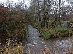
At 53°36′36″N 2°6′40″W / 53.61000°N 2.11111°W / 53.61000; -2.11111 (53.6101°, −2.1111°), and 168 miles (270 km) north-northwest of central London, the centre of Milnrow stands roughly 492 feet (150 m) above sea level, on the western slopes of the South Pennines, 10.4 miles (16.7 km) north-northeast of Manchester city centre. Blackstone Edge and Saddleworth are to the east; Rochdale and Shaw and Crompton are to the west and south respectively. Considered as the area covered by the former Milnrow Urban District, Milnrow extends over 8.1 square miles (21 km), stretching from the Rochdale Canal in the west through to Windy Hill in the east, taking in the valley of the River Beal. The Beal, a tributary of the River Roch, runs centrally through Milnrow from the south through Newhey. The smaller Butterworth Hall Brook, which flows in to the Beal, runs east-to-west, while Stanney Brook rises at High Crompton and runs along the southern edge of Milnrow and in to the Roch at Newbold in Rochdale. The 2001 Merriam-Webster’s Geographical Dictionary recounts Milnrow as both a town and a southeasterly suburb of Rochdale. The Office for National Statistics designates Milnrow as part of the Greater Manchester Built-up Area, the United Kingdom’s second largest conurbation. Milnrow is situated in “the transitional zone” between the moorland of the South Pennines and the more densely populated areas of Rochdale and Manchester. Most development has been built concentrically outwards from two centres by the River Beal in Milnrow and Newhey, but land use transitions as the height of the ground rises towards the Pennines – from commercial and industrial, to housing and suburban development, to enclosed farms and pastures, and finally unenclosed moorland at the highest points. Ancient woodland is sparse; 1 acre (0.0016 sq mi) of woodland and plantation was recorded across Milnrow in 1911. Housing includes 18th-century cottages and farmhouses, late-19th century terraced houses, inter-war social housing, and modern detached and semi-detached private family homes. Farmland typically consists of undulating pastures used for stock rearing and rough grazing, interspersed by isolated farmhouses and the Kitcliffe, Ogden and Tunshill hamlets. Moorland forms the highest and most easterly part of Milnrow—the highest point is Bleakedgate Moor at 1,310 feet (399 m), which forms a boundary with the Metropolitan Borough of Oldham by Denshaw. Windy Hill is another high-point amongst these moors. Milnrow’s soil is typically light gravel and clay, with subsoil of rough gravel, and the underlying geology is mostly lower coal measures from the Carboniferous period, punctuated with a band of sandstone. Milnrow experiences a temperate maritime climate, like much of the British Isles, with relatively cool summers and mild winters. There is regular but generally light precipitation throughout the year. In 1855, the poet Edwin Waugh said of Milnrow:Milnrow lies on the ground not unlike a tall tree laid lengthwise, in a valley, by a riverside. At the bridge, its roots spread themselves in clots and fibrous shoots, in all directions; while the almost branchless trunk runs up, with a little bend, above half a mile towards Oldham, where it again spreads itself out in an umbrageous way.— Edwin Waugh, Sketches of Lancashire life and localities (1855) The urban part of Milnrow broadly consists of development which has absorbed former hamlets including Butterworth Hall, Firgrove, Gallows, and Moorhouse. These now form neighbourhoods of Milnrow, but others form distinct settlements. For instance, Newhey, at the south of Milnrow, emerged as a village in its own right, with its own distinct amenities such as shops, parish church and Metrolink station. Kitcliffe, Ogden and Tunshill, to the east of central Milnrow, are hamlets that occupy the upper, mid and lower Piethorne Valley respectively. The Gallows area is signified by The Gallows public house—it is a former hamlet which now forms a neighbourhood. This area occupies an ancient execution site, established by the Knights Hospitaller in 1253. All continue to form a composite Milnrow area within the borough of Rochdale.
Why visit Milnrow with Walkfo Travel Guide App?
 You can visit Milnrow places with Walkfo Milnrow to hear history at Milnrow’s places whilst walking around using the free digital tour app. Walkfo Milnrow has 90 places to visit in our interactive Milnrow map, with amazing history, culture & travel facts you can explore the same way you would at a museum or art gallery with information audio headset. With Walkfo, you can travel by foot, bike or bus throughout Milnrow, being in the moment, without digital distraction or limits to a specific walking route. Our historic audio walks, National Trust interactive audio experiences, digital tour guides for English Heritage locations are available at Milnrow places, with a AI tour guide to help you get the best from a visit to Milnrow & the surrounding areas.
“Curated content for millions of locations across the UK, with 90 audio facts unique to Milnrow places in an interactive Milnrow map you can explore.”
Walkfo: Visit Milnrow Places Map
90 tourist, history, culture & geography spots
Milnrow historic spots | Milnrow tourist destinations | Milnrow plaques | Milnrow geographic features |
| Walkfo Milnrow tourism map key: places to see & visit like National Trust sites, Blue Plaques, English Heritage locations & top tourist destinations in Milnrow | |||
Best Milnrow places to visit
Milnrow has places to explore by foot, bike or bus. Below are a selection of the varied Milnrow’s destinations you can visit with additional content available at the Walkfo Milnrow’s information audio spots:

Crompton Hall
Crompton Hall was an historic house situated at Crompton Fold in the township of Crompton, Lancashire, and within the historic parish of Prestwich-cum-Oldham .

Stanney Brook
Stanney Brook originates in the Burnedge area of Shaw and Crompton. It flows through Milnrow into Rochdale before joining the River Roch at Newbold Brow. Its name derives from the Lancashire dialect word “stanner”
Hey Brook
Hey Brook is a watercourse in Rochdale, Greater Manchester. It originates at the confluence of Buckley Brook and Syke Brook. It flows through Wardleworth to the River Roch.

St John the Baptist Church, Rochdale
St John the Baptist Church is a Roman Catholic Parish church in Rochdale, Greater Manchester. It was founded in 1830, and built in 1927. It is situated on the corner of Maclure Road and Dowling Street.

Rochdale (ancient parish)
Rochdale was an ecclesiastical parish of early-medieval origin in northern England. At its zenith, it occupied 58,620 acres (237 km) of land amongst the South Pennines. It straddled the historic county boundary between Lancashire and the West Riding of Yorkshire.
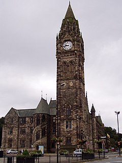
Rochdale Town Hall
Victorian-era municipal building in Rochdale, Greater Manchester, was built in 1871. Built in Gothic Revival style at a cost of £160,000 (£15 million in 2021) It is recorded in the National Heritage List for England as a Grade I listed building. It functions as the ceremonial headquarters of the Metropolitan Borough Council and houses local government departments.

Rochdale Pioneers Museum
The Rochdale Pioneers Museum is housed in the building where the Equitable Pioneers Society started trading on 21 December 1844. The museum includes a recreation of the original shop, containing its rudimentary furniture, scales, items that were sold at the store, etc.

Spodden Valley asbestos controversy
72 acres (290,000 m) of land in Spodden Valley in Rochdale, England, formerly used by Turner Brothers Asbestos Company. Site of world’s largest asbestos textile factory was sold to MMC Estates, a property developer. MMC submitted a planning application to build an “urban village” consisting of 650 homes, a children’s daycare centre and a business park on the site. However, asbestos containing materials were abundantly visible on the ground, and local residents claimed that there were numerous asbestos dumping sites across the area.

Touchstones Rochdale
Touchstones Rochdale is an art gallery, museum, local studies centre, visitor information centre and café. The first part of the building was opened as a library in 1884 with the museum and gallery being added in 1903 and extended in 1913. It became an art and heritage centre in 2003.

Rochdale Infirmary
Rochdale Infirmary is an acute general hospital in Greater Manchester. It is managed by the Pennine Acute Hospitals NHS Trust.
Visit Milnrow plaques
 28
28
plaques
here Milnrow has 28 physical plaques in tourist plaque schemes for you to explore via Walkfo Milnrow plaques audio map when visiting. Plaques like National Heritage’s “Blue Plaques” provide visual geo-markers to highlight points-of-interest at the places where they happened – and Walkfo’s AI has researched additional, deeper content when you visit Milnrow using the app. Experience the history of a location when Walkfo local tourist guide app triggers audio close to each Milnrow plaque. Explore Plaques & History has a complete list of Hartlepool’s plaques & Hartlepool history plaque map.


 Trying to encourage visitors to Milnrow?