Welcome to Visit Milburn, Cumbria Places
The Walkfo guide to things to do & explore in Milburn, Cumbria
 Visit Milburn, Cumbria places using Walkfo for free guided tours of the best Milburn, Cumbria places to visit. A unique way to experience Milburn, Cumbria’s places, Walkfo allows you to explore Milburn, Cumbria as you would a museum or art gallery with audio guides.
Visiting Milburn, Cumbria Walkfo Preview
Milburn is a small village and civil parish in the Eden district of Cumbria, England. It is located on the northern side of the Eden Valley, about 9 miles (14.5 km) east of Penrith. The parish includes the outlying hamlets of Gullom Holme and Milburn Grange, respectively 0.5 miles (0.8 km) and 1.25 miles (2.0 km) from the village centre. When you visit Milburn, Cumbria, Walkfo brings Milburn, Cumbria places to life as you travel by foot, bike, bus or car with a mobile phone & headphones.
Milburn, Cumbria Places Overview: History, Culture & Facts about Milburn, Cumbria
Visit Milburn, Cumbria – Walkfo’s stats for the places to visit
With 8 audio plaques & Milburn, Cumbria places for you to explore in the Milburn, Cumbria area, Walkfo is the world’s largest heritage & history digital plaque provider. The AI continually learns & refines facts about the best Milburn, Cumbria places to visit from travel & tourism authorities (like Wikipedia), converting history into an interactive audio experience.
Milburn, Cumbria history
The most striking feature of Milburn is the consistency of its layout. This appears to imply a high degree of planning, and the history of the village may most usefully be described in this context. The houses round the green present a continuous frontage broken only by narrow lanes giving access to the farmyards, barns and fields which lie behind. Roads and tracks enter at the corners of the green and access is so restricted at some points that it has been suggested that the village has been constructed on defensive lines – possibly against the Border Reivers. Disappointingly, however, no buildings from “Reiving” times (late 13th to the end of the 16th century) survive, at least within the vicinity of the green itself. In fact the earliest structures here date from the mid-18th century, with the majority reflecting a major period of rebuilding in the 19th century. The quality of these buildings, however, is of such interest that Milburn has been selected by Brunskill to provide an exemplar of Lake District architecture. That Milburn had an earlier history on its present site is clearly signalled by the field-system radiating from the existing village. The evidence of a typical medieval layout is plain to see, with long narrow fields separated by hedges where groups of strips from the old open town fields have been brought together. This evidence is further underlined by remnants of ridge and furrow in many of the fields. However, Roberts argues that village development was taking place in most cases before 1200 and in some cases as much as two centuries earlier. In the case of Milburn there is the strong presumption of prehistoric occupation in the general area. Brennand states that cereal pollen dating to 4000BC has been found at Howgill on the outskirts of the village. Goodchild describes evidence of hut circles and other traces of early occupation on the fell side above Milburn at NY69700/30290, NY69230/32120 and NY68720/32700. A bronze celt was found in a field above Lounthwaite to the west of the village. Further afield there are presumed Iron Age “farmsteads” at Kirkland and Dufton. That there was a time during the civilised period when there was no significant occupation at all on the present site is strongly suggested by the fact that the main road from Dufton to Blencarn by-passes the modern village entirely, running to the south between the modern green and the church. This road has unusual features. It is noticeably straight and, between Long Marton and Milburn, it is known as High Street. Then, as it goes past Milburn, it becomes Low Street. Richardson has suggested that it is a very ancient track way (based on alignment considerations). Butterworth postulates that it may be Roman (from naming evidence and its straightness). The main point is that the road appears to be of ancient origin and takes no account of the village The existence of other significant relics of occupation outside the present village area suggests that when significant nucleated settlement did occur it initially happened elsewhere. In particular, the existence of the church to the south of the modern village strongly suggests that the initial focus of settlement (as opposed to isolated farmsteads) was here. The church, together with the churchyard, occupies a neck of land bounded by two becks flowing in steep-sided ravines which contain several natural strong-running springs. One of these at NY 649/292 is so voluminous and reliable that in recent years it has been capped as a farm supply. In a copse at NY 657/292 there is yet another spring. This is known as Keld Well and is believed by Page to have had religious significance as a place of pilgrimage. A second possibility for a site of settlement is the curious wiggle in Low Street at the point where the road from Newbiggin crosses to enter the outskirts of the present village. This might well be the fossil record of some sort of hamlet. It seems possible, therefore, that the unusual coherence of the layout of Milburn on its present site arises from the fact that when settlement finally took place the site was still largely or wholly undeveloped. This further suggests a concerted, motivated development. According to Butterworth, the first documentary reference to “Milburn” dates from 1200/1 when King John (1199–1215) granted the forest of Milburn to William de Stuteville, Lord of the Barony of Cottingham near Hull. The term “forest” in this context refers to an area suitable for hunting rather than forestry in its modern sense. Of course, this in no sense implies that the modern village dates from this period, nor that there was necessarily a “Burn” and a “Mill” here. Goodchild argues that the name is actually derived from Mil Borran, meaning a stone by a Roman road. Curiously on the edge of the road at the entrance to the lonning leading to the church at NY65360/29165 there is an ancient stone which is registered on the Sites and Monuments Record (SMR) as a cross base. Nevertheless, there was evidently a settlement somewhere in the vicinity which projected at least the continuity of its name into modern times. The prospect of planned settlement actually arises rather earlier with an entry in the Anglo-Saxon Chronicle for 1092 which refers to King William (Rufus) travelling north to Carlisle with a large army, restoring the town, raising the castle and driving out Dolfin who earlier had ruled the land there. It goes on to say: “[He] afterwards returned south here and sent very many peasants there with women and with livestock to live there to till that land.” Whatever the precise stimulus and the exact date of the migration of the village to its present site, it must have occurred in time to create the medieval field system. Butterworth argues that the most likely date would have been around 1340 to coincide with the construction of Howgill castle, although he accepts that an earlier date, prompted by raids into England by De Bruys in 1311 would also be possible. He points out that once the Lancasters became Lords of the Manor soon after 1335, they had a direct vested interest in protecting both their tenants and their tenants livestock, so that the laying out of a defensible village and the building of Howgill Castle might have gone hand in hand Assuming, for the sake of romance at least, that the development was indeed planned, Butterworth considers whether the modern arrangement of houses and farms round the central green took shape as a single act of concerted construction or, as would seem more likely, took place in a staged, “organic” fashion. It is his belief that the original village consisted of a single line of cottages (presumably cruck-framed, thatched with turf or heather and with walls of wattle and daub, clay or roughly-piled field stones) along the south-east side of the green and fronting onto the back lane that runs alongside this side of the village. This theory of course reverses the current orientation of the houses on this side, but Butterworth sees no problem here. Under his theory, the green would then have taken the form of an enclosure behind these properties and he suggests that further properties would then have spread around this enclosure. Re-orientation of properties to accord with the current layout would have taken place as houses were gradually improved and replaced and it was found convenient to regard the green as the centre of the village. In support of his view he point out that access to farm buildings on the south east side has always been from the back lane, whereas on the north west side the gaps between houses have always been much larger, so enabling access to the farmyards to be made from the green. There has never been a back lane on the north west side, although there are vestiges of such lanes on the north east and south west. The modern “front gardens” of properties round the green were enclosed gradually over a number of years with the consent of the Lord of the Manor. The subsequent waves of rebuilding which have resulted in the total eradication of the earlier medieval structures are easily explained by the parallel phases of development seen elsewhere in the county. In particular the “Age of Improvement”, roughly from 1750 to 1850 saw rapid gains in agricultural and industrial efficiency. Milburn would have benefited significantly from enhanced crop yields and from the opening of the mines which also occurred at this time (references to the rich Silverband mine on Dun Fell, behind the village, appear from 1709). The scale of the improvement in rural fortunes is demonstrated by the stylish ambition guiding the design of the replacement buildings. Doors are adorned with classical features such as architraves and pediments, and windows are surrounded by elaborate mouldings. It seems likely that medieval structures first began to disappear at this time, the process being consolidated as the improvement in the wealth of the village continued during the 19th century. The flimsy nature of the earlier structures has ensured that nothing from the medieval phase survives, though it is notable that many of the replacement buildings contain timbers which have clearly had an earlier history. It is very common, for example, to find exposed oak beams which now support floors but which contain joints which show they used to be part of a roof. Similarly many beams are drilled to show they once formed part of wattle and daub partitions. Taken together with a very limited number of recent developments dating from the 20th and 21st centuries, this is the village in its present form.
Milburn, Cumbria landmarks
Howgill Castle
Howgill Castle is a fortified manor house 1 km to the east of the main village and at a slightly higher elevation. Butterworth believes that it dates from about 1340. It is defended to the north west by a deep ravine and commands extensive views.
St Cuthbert’s Church
St Cuthbert’s Church lies in an isolated position about 0.5 km across fields to the south west of the village. It is claimed that the body of St.Cuthbert rested here in 876 when monks from Lindisfarne fleeing the Viking invaders toured the county bearing holy relics of their saint with them.
Methodist Chapel
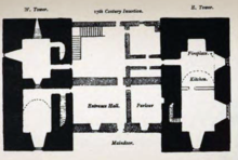
The former Methodist Wesleyan Chapel located at the west end of the Green is now a private residence. It was built in 1834 and accommodated 90 seated. Butterworth estimates that by the 1860s half of the village’s population were probably Methodists.
Maypole
There has been a maypole on this site in Milburn for at least 150 years. The present Maypole was erected in 2014 after it was agreed that the old one was becoming unsafe.
Milburn, Cumbria geography / climate
The village stands on a shelf of Saint Bees sandstone, overlain by thick layer of glacial deposits. Sandstone underlies most of the Eden Valley and runs beneath volcanic deposits of the Lake District to emerge eventually on the Solway coast. The soils also contain many rounded boulders of varying sizes which, because of their hardness provide a valuable building material.
Why visit Milburn, Cumbria with Walkfo Travel Guide App?
 You can visit Milburn, Cumbria places with Walkfo Milburn, Cumbria to hear history at Milburn, Cumbria’s places whilst walking around using the free digital tour app. Walkfo Milburn, Cumbria has 8 places to visit in our interactive Milburn, Cumbria map, with amazing history, culture & travel facts you can explore the same way you would at a museum or art gallery with information audio headset. With Walkfo, you can travel by foot, bike or bus throughout Milburn, Cumbria, being in the moment, without digital distraction or limits to a specific walking route. Our historic audio walks, National Trust interactive audio experiences, digital tour guides for English Heritage locations are available at Milburn, Cumbria places, with a AI tour guide to help you get the best from a visit to Milburn, Cumbria & the surrounding areas.
“Curated content for millions of locations across the UK, with 8 audio facts unique to Milburn, Cumbria places in an interactive Milburn, Cumbria map you can explore.”
Walkfo: Visit Milburn, Cumbria Places Map
8 tourist, history, culture & geography spots
Milburn, Cumbria historic spots | Milburn, Cumbria tourist destinations | Milburn, Cumbria plaques | Milburn, Cumbria geographic features |
| Walkfo Milburn, Cumbria tourism map key: places to see & visit like National Trust sites, Blue Plaques, English Heritage locations & top tourist destinations in Milburn, Cumbria | |||
Best Milburn, Cumbria places to visit
Milburn, Cumbria has places to explore by foot, bike or bus. Below are a selection of the varied Milburn, Cumbria’s destinations you can visit with additional content available at the Walkfo Milburn, Cumbria’s information audio spots:
Visit Milburn, Cumbria plaques
 0
0
plaques
here Milburn, Cumbria has 0 physical plaques in tourist plaque schemes for you to explore via Walkfo Milburn, Cumbria plaques audio map when visiting. Plaques like National Heritage’s “Blue Plaques” provide visual geo-markers to highlight points-of-interest at the places where they happened – and Walkfo’s AI has researched additional, deeper content when you visit Milburn, Cumbria using the app. Experience the history of a location when Walkfo local tourist guide app triggers audio close to each Milburn, Cumbria plaque. Currently No Physical Plaques.


 Trying to encourage visitors to Milburn, Cumbria?